Sell Your Traveller’s Map of The State of Texas Charles M Pressler c 1867 for up to Nearly $20,000 or More at Nate D. Sanders Auctions
FREE ESTIMATE. To buy, auction, sell or consign your Traveller’s Map of the State of Texas Charles M Pressler c 1867 that is for sale, please email your description and photos to [email protected] of Nate D. Sanders Auctions (http://www.NateDSanders.com).
Sell Your Traveller’s Map of the State of Texas Charles M Pressler c 1867
Below is a recent realized price for a Traveller’s Map of the State of Texas Charles M Pressler c 1867 item. We at Nate D. Sanders Auctions can obtain up to these amounts or more for you:
Traveller’s Map of the State of Texas Charles M Pressler c 1867. Sold for nearly $20,000.
Here are some recent items that our auction house, Nate D. Sanders (http://www.NateDSanders.com) has sold:
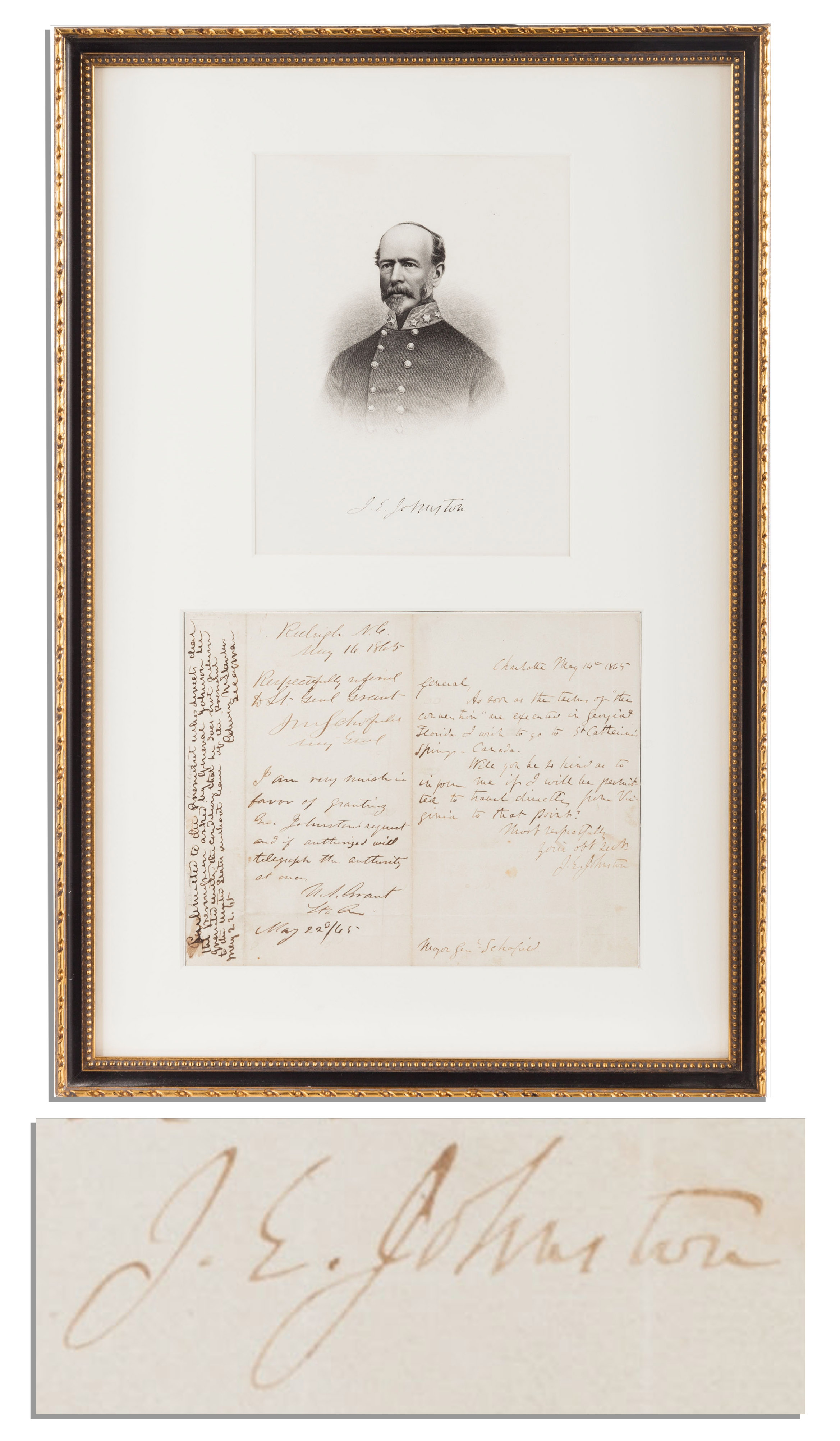
Confederate General Joseph E. Johnston autograph letter signed ”J.E. Johnston”, dated 16 May 1865 from Charlotte, North Carolina, written soon after being released on parole by the Union Army. Also with three endorsements signed by Ulysses S. Grant, Secretary of War Edwin Stanton and General John Schofield. Letter is addressed to General Schofield, just two weeks after Johnston surrendered his Army of Tennessee and still active rebel troops. After both parties agreed to military surrender, Johnston and Schofield negotiated supplementary terms, including his soldiers’ release, and here asks permission to travel to Canada. Reads in part: ”…As soon as the terms of ‘the convention’ are executed in Georgia & Florida, I wish to go to St. Catherine’s Springs, Canada. Will you be so kind as to inform me if I will be permitted to travel directly from Virginia to that point? Most respectfully / Your obt sevt / J.E. Johnston”. General Schofield endorses the letter on 16 May, the same day, ”Respectfully refered [sic] to Lt. Gen. Grant. J M Schofield Maj Genl.” Grant then endorses the letter on 22 May: ”I am very much in favor of granting Gen. Johnston’s request and if authorized will telegraph the authority at once. U. S. Grant Lt. Gen.” Lastly, Secretary of War Edwin M. Stanton seeks approval from President Johnson: ”Submitted to the President who directs that the permission asked by General Johnson [sic] be granted with the condition that he does not return to the United States without leave of the President. Edwin M Stanton Sec of War.” Letter on one page measures 8” x 6.25”, matted with a portrait of Johnston to an overall size of 12.5” x 18.25”. Light toning and folds throughout; very good to near fine. A U.S. Grant autograph is rare dated during the Civil War or directly relates to the Civil War as this one does. Sold for $12,500.
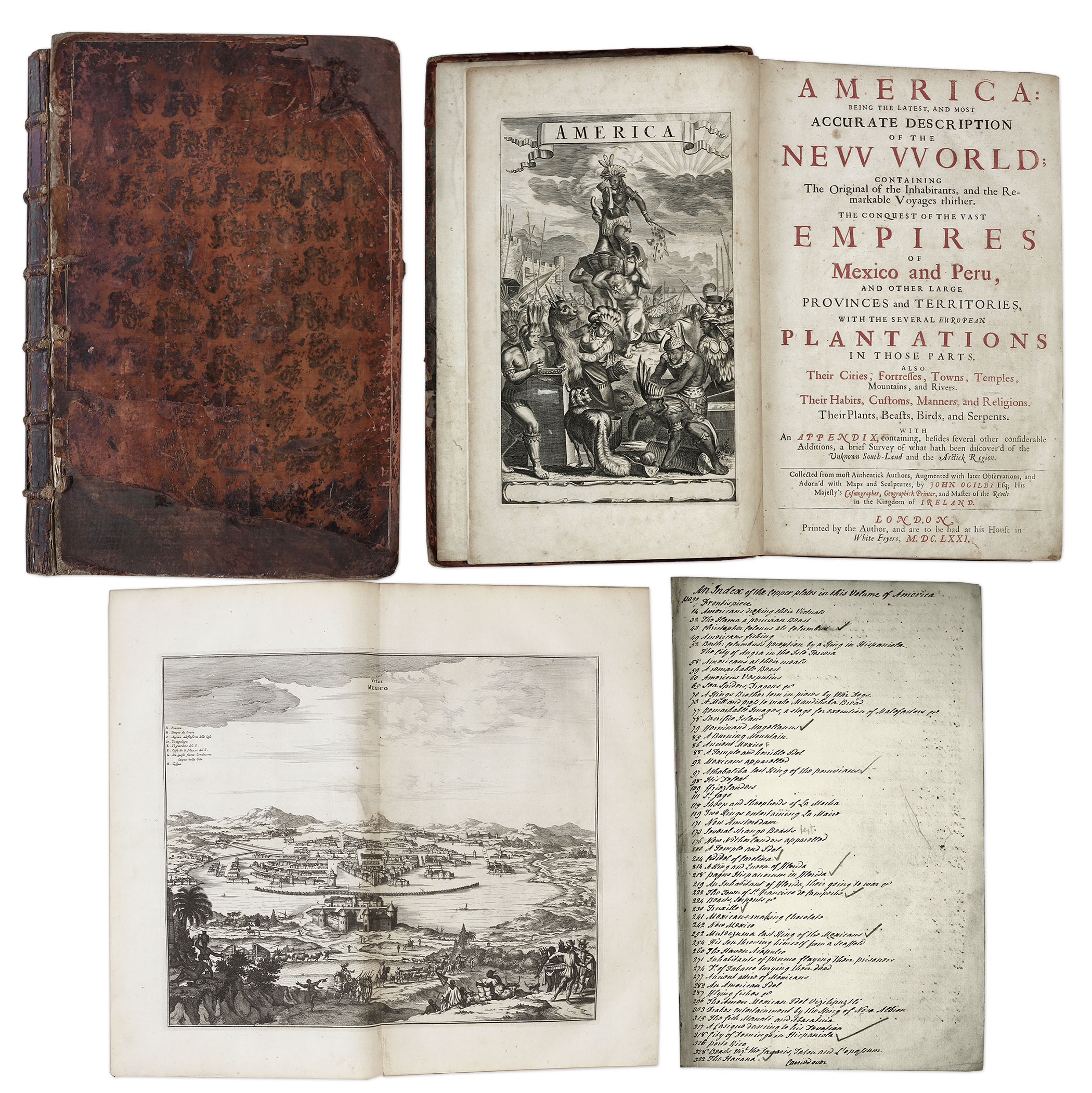
One of the most important books on the history of America (cited by Borba de Moraes, Howes, Sabin and Wing), the 1671 first edition of ”America: Being the Latest and Most Accurate Description of the New World”. Privately printed in London by the author, Arnoldus Montanus, and edited by John Ogilby. In ”America” Montanus goes into great detail of the new continents, with dozens of engravings of Native Americans, species of animals and reptiles, and the landscapes and settlements in the new world, accompanied by text. The book covers speculation regarding the earliest voyages to America, along with later recorded voyages and the settlements of New Netherlands/New York, New England, Hudson’s Bay, Labrador, Canada, Nova Scotia, Maryland, Virginia, (including Captain Smith’s capture and rescue by Pocahontas), Carolinas, Florida and California, plus accounts of Mexico and nearby islands, even including Australia and New Zealand. 674pp. book contains 75 original engravings (64 copper plates within the text and 9 plates throughout), lacking the maps and 28 engravings, which is typical as this edition is almost never found with all plates intact. All text is complete except for missing pages 445-446. Large format book measures 10” x 15”. Bound in original full leather boards, with some loss of leather to covers, cracking along spine and front board detached. Interior text is near fine and very readable. An important and fascinating addition to early knowledge of the American continent. Sold for $9,375.
Revolutionary War Map 1776
Revolutionary War map dated March 1776. “The Theatre of War in North America, With the Roads and a Table of the Distances…” Printed in London for R. Sayer and J. Bennett. Map depicts the area east of the Mississippi River from James Bay to Cape Canaveral, and locates provincial boundaries, towns, forts, roads, Indian villages, New England fishing waters, and the like. An inset is comprised of “Evan’s Polymetric Table of America,” which allows one to calculate the distance between most of the prominent towns. Text below the map reads, “A Compendious Account of the British Colonies in North America,” which devotes a paragraph of description to each of the North American colonies, including Florida, Canada, and the Province of Quebec. Issued separately by Sayer and Bennett, who also published “the American Military Pocket Atlas,” that year for the use of British officers. A notable map of the American Revolution, published the same year as the American Declaration of Independence. 20.75″ x 28.5″; 29.25″ x 37.5″ framed. Excellent condition. Sold for $6,000.

Auction your Traveller’s Map of the State of Texas Charles M Pressler c 1867 at Nate D. Sanders Auctions. Send a description and images of your Traveller’s Map of the State of Texas Charles M Pressler c 1867 to us at [email protected].
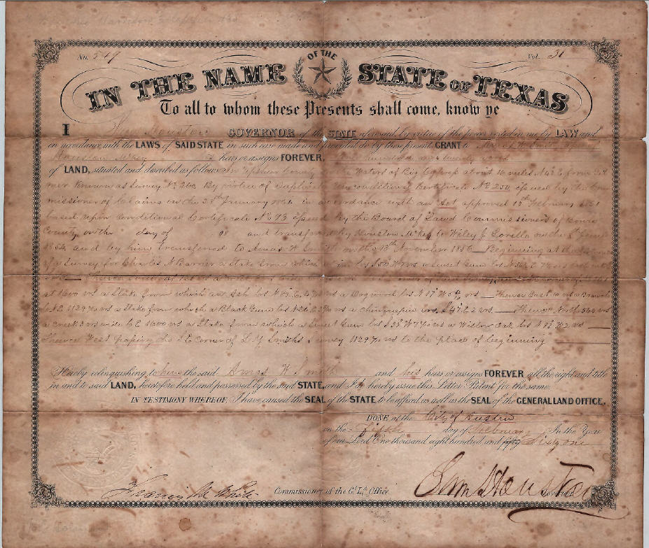
Sam Houston Signed Texas Land Grant
Exceptionally large signature of Sam Houston on Texas land grant, signed as the Governor of Texas. Upshur County land grant is dated 5 February 1861 and measures 12.5″ x 14.75″ with Houston’s signature at bottom right measuring 1″ x 4″. State of Texas blindstamped seal on bottom left. Document folded into eighths, with toning along foldlines. Foxing present along edges. Three small holes along center foldlines and registration docket writing to verso. Document overall in good condition with bold large signature an exceptional plus. Sold for $4,936.
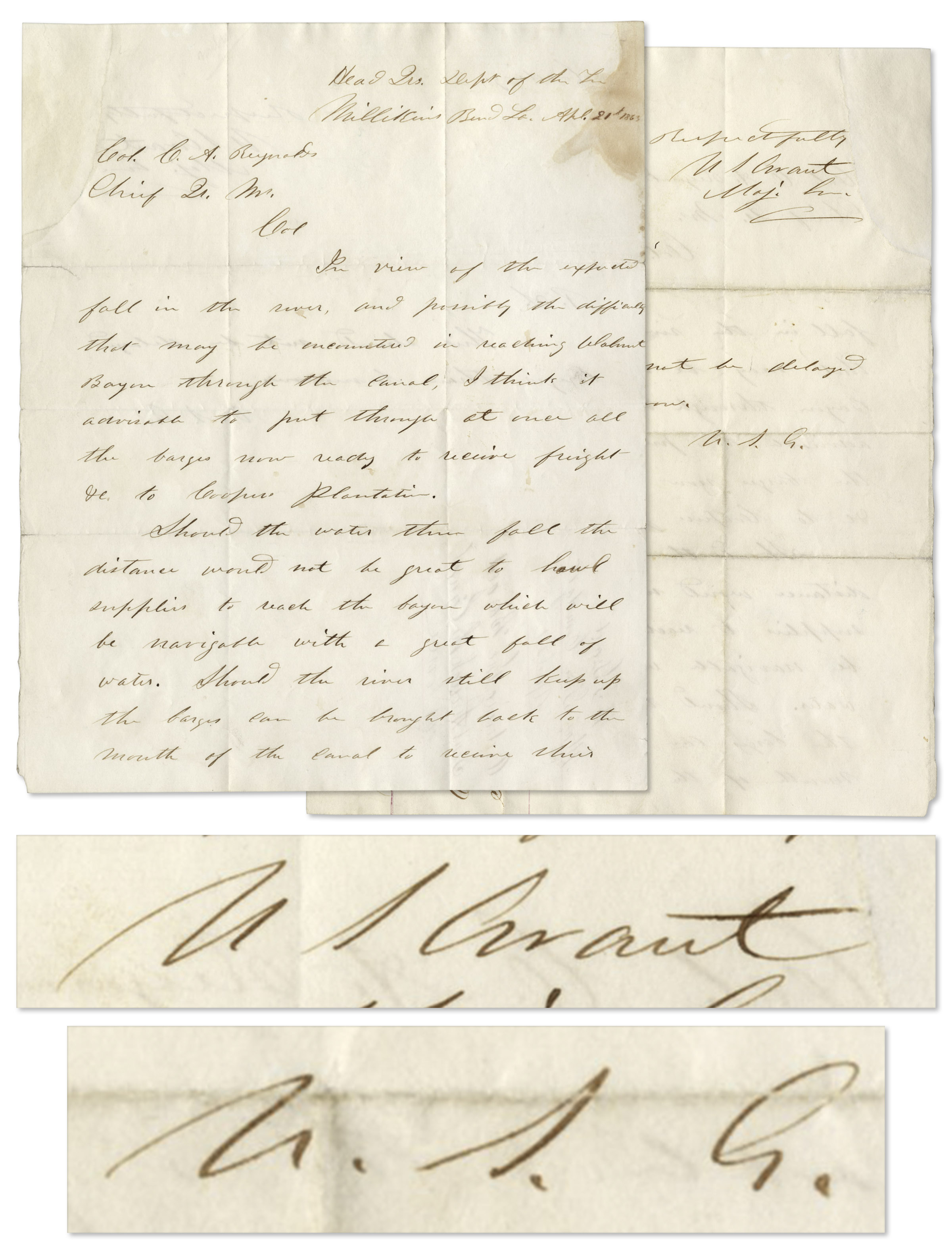
U.S. Grant autograph letter twice-signed, dated 21 April 1863, while Grant served as Major General for Union forces. The 18th U.S. President writes to Colonel C.A. Reynaud in Millikins Bend, Louisiana in full: ”In view of the expected fall in the river, and possibly the difficulties that may be encountered in reaching Walnut Bayou through the Canal, I think it advisable to put through at once all the barges now ready to receive freight &c. to Cooper’s Plantation. Should the water there fall the distance would not be great to haul supplies to reach the bayou which will be navigable with a great fall of water. Should the river still keep up the barges can be brought back to the mouth of the canal to receive their loading. / Respectfully / US Grant / Maj. Gen.” In a postscript Grant adds, ”This should not be delayed longer than to-morrow / U.S.G.” Five days prior, Grant had ordered Union troops under fire in Vicksburg to meet up with his troops at the West side of the Mississippi. This move confused the Confederate Army and led to a victory at the Battle of Champion Hill on 16 May 1863. 2pp. letter is written in ink on one page, front and back. Measures 8” x 10”. Folds, dampstaining to top right corner and archivally repaired tear at left edge. Overall very good condition with bold and legible writing. A U.S. Grant autograph is rare dated during the Civil War. Sold for $3,781.
U.S. Grant Autograph on a CDV Photo – With PSA/DNA COA
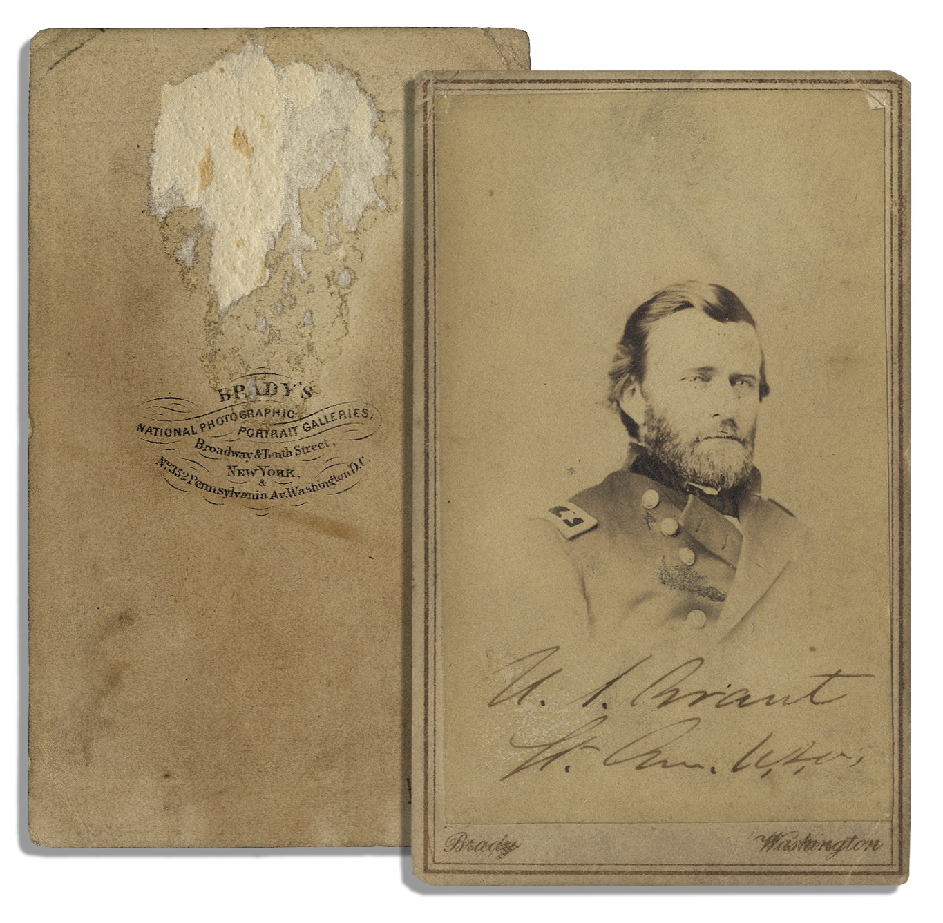
U.S. Grant autograph on a carte de visite photo, ”U.S. Grant / Lt. Gen. U.S.A.” upon the image. CDV by Brady measures 2.5” x 4”. Toning, slight peeling to upper right corner and evidence of prior mounting to verso, else near fine. Accompanied by PSA/DNA COA. A U.S. Grant autograph is pricey when signed on a CDV. Sold for $2,500.
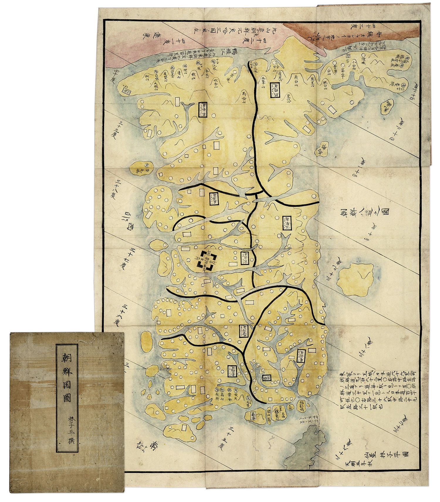
Hand-painted map of Korea by Hayashi Shihei, from Japan, circa 1785. Fold-out map shows the kingdoms outside Japan’s boundaries, but with the Kingdom of Joseon (Korea) being an important trading partner, the map was considered dangerous, and consequently banned by the Shogun in 1792. Has original cover boards and title slip. Measures 20” x 29” when folded out, and 7” x 9.5” when closed. Lightly toned and soiled, overall very good condition. Sold for $1,563.
FREE ESTIMATE. To buy, auction, sell or consign your Traveller’s Map of the State of Texas Charles M Pressler c 1867 that is for sale, please email your description and photos to [email protected] of Nate D. Sanders Auctions (http://www.NateDSanders.com).
We offer the following services for your Traveller’s Map of the State of Texas Charles M Pressler c 1867:
- Appraise Traveller’s Map of the State of Texas Charles M Pressler c 1867.
- Auction Traveller’s Map of the State of Texas Charles M Pressler c 1867.
- Consign Traveller’s Map of the State of Texas Charles M Pressler c 1867
- Estimate Traveller’s Map of the State of Texas Charles M Pressler c 1867.
- Sell Traveller’s Map of the State of Texas Charles M Pressler c 1867.