NateDSanders.com Has the Best Rare Book Auction

FREE APPRAISAL. To auction, buy, consign or sell in our monthly rare book auction, please email [email protected], call (310) 440-2982 or see http://www.NateDSanders.com monthly rare book auction.
Rare Book Auction
Determining if a book is a true first edition is often a truly complicated business — whole books have been written just to explain the rather erudite system of classification.
Take this video, for example, provided by our friends at Abe Books, that lays the general guidelines out:
We here at the Nate D. Sanders Rare Book Auction take pride in our collection of literary letters and first editions auctioned over the years from some of the most famous authors in history — from the letters of Jonathan Swift to Dr. Seuss’ quirky illustrations, we’ve been given a rare glimpse into their creative outlooks, both in their work in in their lives.
Here’s a rundown of some of the most exceptional items sold over the past few years:
In 2010, we obtained a record price for this Dr. Seuss item obtained directly from his secretary:
Dr. Seuss’s Late 1960’s Never-Before Known, Unpublished, Abandoned & Unfinished Very Rough & Beginning Draft of a Children’s Book Manuscript Entitled “All Sorts of Sports” — With Seuss’ Handwritten Rhymes and Doodles Throughout
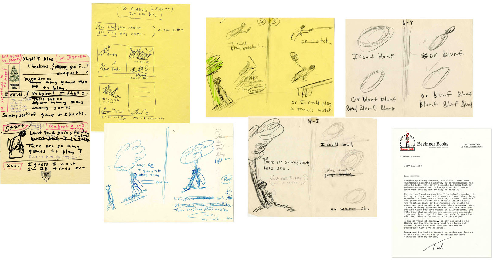
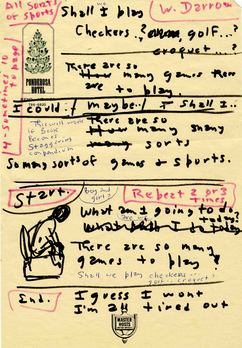
Nineteen handwritten pages, the first seven of which are completely in the hand of Dr. Seuss. The remaining pages are mostly written by an assistant with corrections and doodles by Dr. Seuss, some taped on. This Dr. Seuss children’s book lost for over 40 years reads in part including the scratched out parts, “All Sorts of Sports. Shall I play checkers? golf? croquet? There are so many games there are to play. I could. / maybe.. / shall I.. There are so many many sorts. So many sorts of games + sports. What am I going to do today? There are so many games to play! I guess I won’t. I’m all tired out. 100 GAMES & sports you can play. You can play checkers. You can play chess. Baseball. Football. Volleyball. Basketball. You can ski on snow. You can ski on water. And tiddle-de-winks. What am I going to do today. Well, that’s a simple matter. Oh, that’s easy. We could play. There are so many sports games to play. We could swim. I could play baseball…golf..or catch. Or I could play a tennis match. There are so many sports, let’s see… I could bowl, jump hurdles, or water ski. I could blumf. Or blumf blumf blumf blumf blumf. Or blumf. Or blumf blumf blumf blumf blumf.” This last page, marked page “6-7” by Dr. Seuss seems to be where the assistant takes over, though Seuss adds corrections and doodles, as mentioned before, some taped on. Accompanied by a Dr. Seuss typed letter signed “Ted” regarding this unfinished sports book on Cat in the Hat Beginner Books stationery dated 11 July 1983. Seuss responds to a letter from one of his assistant writers (letter also included, dated 31 May 1983) where the assistant writes, “About 14 years ago, you wanted a sports book for Beginner Books. I worked on one, but what I eventually came up with did not please you…So I set it aside. I have just found it in an old file, and am thinking I might try submitting it to a few places to see what happens. Before I do that, I want to let you have another look at it…” Seuss responds in part, “Re your enclosed manuscript, I do indeed remember it. And my critique now is as same as then. What, in my opinion, is wrong with this story is that…despite the greatness of Pete as a stellar athlete hero…the negative image of him flubbing and unable to catch any ball at all will make him schnook. This is not entirely apparent in the text, but when you picture these negative scenes in illustrations, you will find that negatives are always more memorable than positives. And I think the reader’s reaction will be, ‘What’s the matter with this dope?’ I may be wrong of course…so why not send it to Harper and Row who do very good brat books and several times have made best sellers out of properties that I’ve rejected. ” It seems as if Seuss’ sports manuscript — focusing on “What game shall we play today?” — varied from this writer’s concept of the athlete who couldn’t catch. A miraculous find in excellent condition. Never before seen on the market. Accompanied by letter of authenticity from Seuss’ assistant writer to whom this manuscript was given.
It sold for $40,805. One of the reasons it obtained such a high price is that we garnered a lot of press attention including a story by NPR.
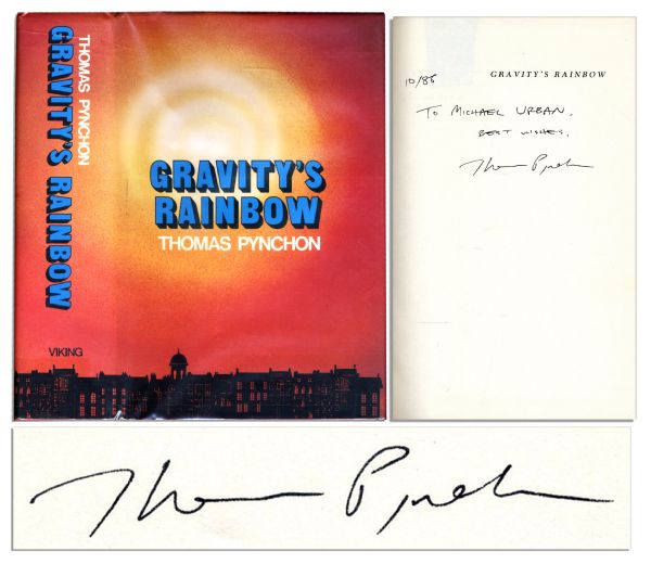
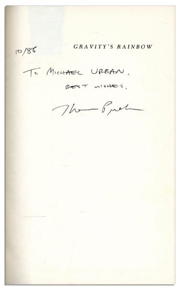
From one of the most hermetic authors in history, Thomas Pynchon, whose tour de force “Gravity’s Rainbow,” arguably one of the most dense and complex stories in contemporary literature —
We sold a first edition, first printing of Thomas Pynchon’s masterpiece, “Gravity’s Rainbow.” It sold for $21,013 in our 2011 rare book auction.
We auctioned an historic collection of rare autograph letters signed by revered author Jonathan Swift. Like this 1736 autograph letter signed by Swift which sold for $19,103. Read about the collection here.

Few authors continue to define the landscape of American literature through timeless themes woven into elegant prose as F. Scott Fitzgerald does. Take, for instance, the powerful ending line of “The Great Gatsby”:
“So we beat on, boats against the current, borne back ceaselessly into the past.”
Critic John Chamberlain once described Fitzgerald’s talents in his “ability to catch the flavor of a period, the fragrance of a night, a snatch of old song, in a phrase.”

via PermanentStyle
We’ve auctioned many high-value F. Scott Fitzgerald items, including:
This incredibly rare F. Scott Fitzgerald typed letter signed, devoted entirely to Fitzgerald’s revealing the people who impacted his writing. It sold at our rare book auction for $13,045.
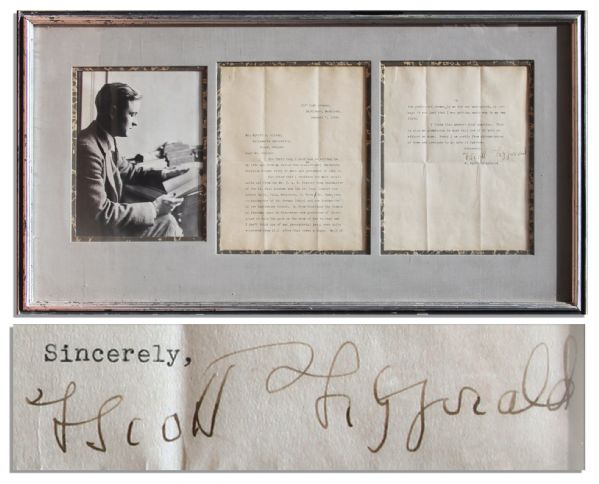
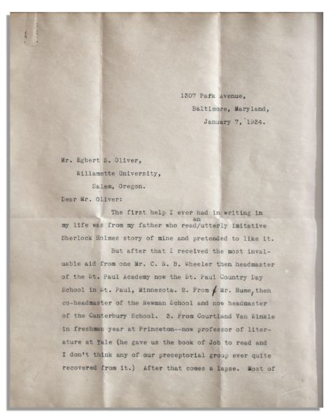
Written toward the end of his life on January 7th 1934, he charmingly writes, “The first help I ever had in writing in my life was from my father who read an utterly imitative Sherlock Holmes story of mine and pretended to like it…”
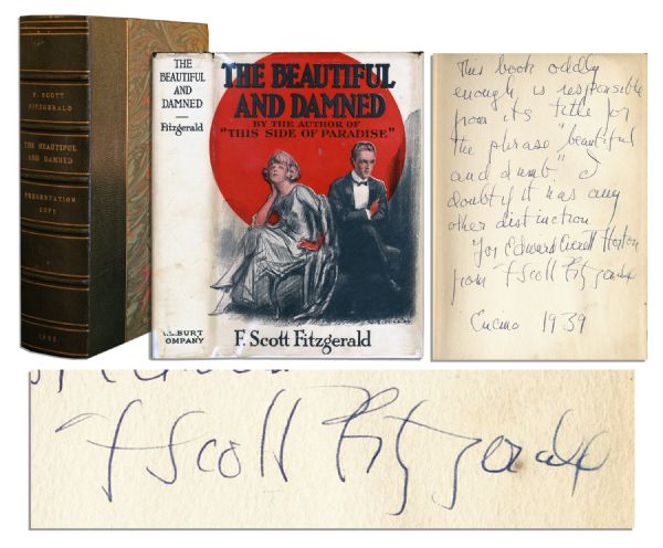
We also sold this signed and inscribed first edition, third printing of F. Scott Fitzgerald’s ”The Beautiful and Damned.” It sold privately for $11,000.
We sold a signed first edition, first printing of ”Tender is the Night” featuring Fitzgerald’s autograph inscription to actress Helen Hayes. It sold for $12,500 privately.
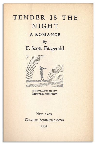
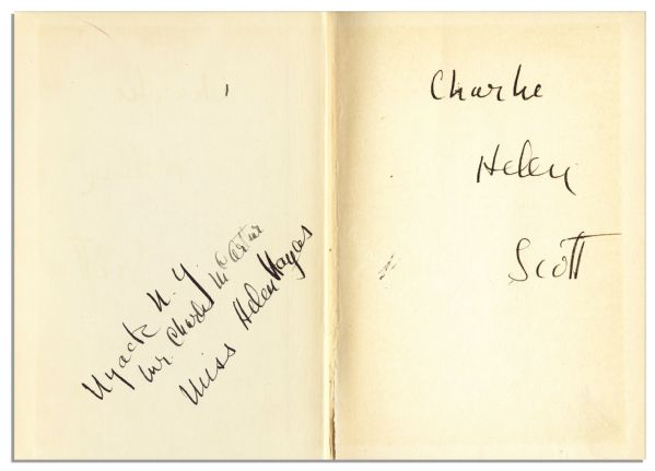
Fitzgerald lists the name of Hayes’ husband ”Charlie”, her name ”Helen”, and signs simply, ”Scott” on the front free endpaper. Opposite he inscribes the front pastedown ”Nyack N.Y. / Mr. Charlie MacArthur / Miss Helen Hayes”.
Again defining the canon of American literature, with a book still read in every classroom in America, Harper Lee is another acclaimed author whose letters and first editions we’ve sold over the years.
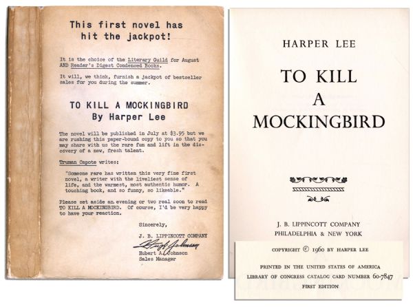
We auctioned this advance reading copy of Harper Lee’s ”To Kill a Mockingbird” with a letter by J.B. Lippincott Co. sales manager printed on the front wrapper. It sold for $8,098 at our rare book auction. It’s exceedingly rare as only 400-500 advance reading copies of ”To Kill a Mockingbird” were printed, and only a handful are known to exist today.
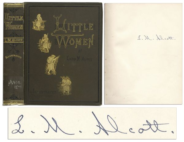
As yet another famous woman author who wrote during a time when women’s literary voices were seldom heard, we auctioned Louisa May Alcott signed ”Little Women,”. This 1880 edition is exceedingly rare as Alcott signs her masterpiece: ”L.M. Alcott” on the fly-leaf. An Alcott signed instance of ”Little Women” had not been sold at auction in over 4 decades. It sold for $8,908.
In the realm of children’s literature, we’ve auctioned the original artwork of “Madeline” creator, Ludwig Bemelmans —
Ludwig Bemelmans large, colorful watercolor signed from his beloved ”Madeline” book series. It sold for $8,908 in a 2012 books auction.
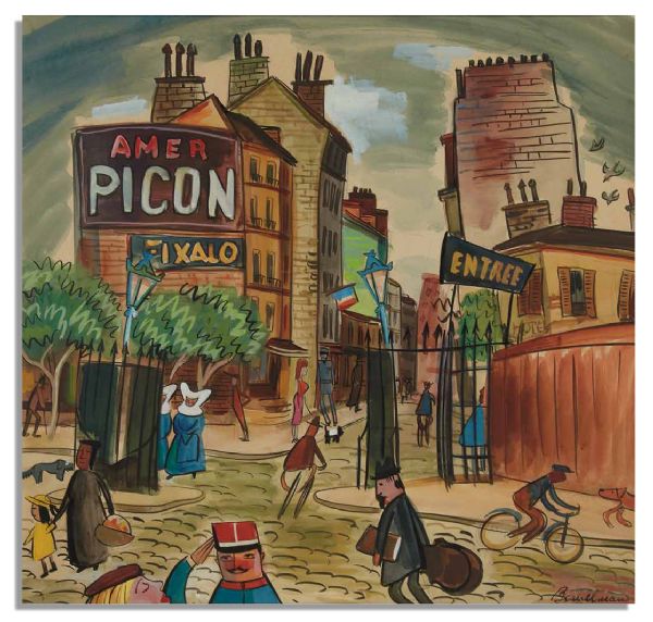
This whimsical piece of art portrays a Parisian street scene containing the Madeline characters, as the setting of the book took place in a Catholic boarding school in Paris.
Salinger has been in the news often this past year, as new biographies, plays, and documentaries exploring the personal life of the most hermetic of authors have all come out the past few months.
Our rare book auction auctioned an exceptionally rare item illuminating Salinger’s private life —
J.D. Salinger typed letter, clearly signed ”J.D. Salinger” in blue ink, dated 14 May 1966 and written while on a trip to Bermuda. It sold for $9,424 in a 2012 rare books auction.
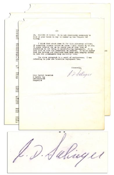
Check out this extensive blog detailing the letter at our rare book auction:
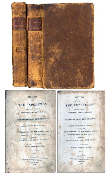
And finally, we auctioned a this first edition, two-volume set of ”History of the Expedition under the Command of Captains Lewis and Clark to the source of the Missouri thence across the Rocky Mountains and down the river Columbia to the Pacific Ocean performed during the years 1804-05-06 by Meriwether Lewis and William Clark”. It sold for $6,544.
Be sure to check out our wide collection of rare first editions and literary letters in our upcoming rare book auction!
FREE APPRAISAL. To auction, buy, consign or sell with our rare book auction, please email [email protected] or call that Nate D. Sanders Auction House (http://www.NateDSanders.com) at (310) 440-2982.
Please let us know if you have items to sell in our rare book auction. Top dollar obtained for your items in our rare book auction.
Nate D. Sanders Auctions offers the following services for our rare book auction:
- Appraise items for rare book auction
- Auction items for rare book auction
- Consign items for rare book auction
- Sell items for rare book auction
- Buy items for rare book auction
- Research items for rare book auction
- Assess items for Rare book auction
- Authenticate items for rare book auction
- Estimate items for rare book auction
- Prices realized rare book auction
- Value items for rare book auction
- Rare book auction appraisal
- Rare book auction consignment
- Rare book auction research
- Rare book auction authentication
- Rare book auction estimate
- Rare book auction value
- Rare book auction estimation
- Rare book auction cost
- Rare book auction valuation
- Rare book auction signed
- Rare book auction appraisement
- Rare book auction first edition
- Rare book auction autographed
- Rare book auction prices realized