Sell or Auction Your Nicolas de Nicolay Le Navigationi et Viaggi Nella Turchia 1580 for Nearly $20,000 or More at Nate D. Sanders Auctions
FREE APPRAISAL. To buy, auction, sell or consign your Nicolas de Nicolay Le Navigationi et Viaggi nella Turchia 1580 that is for sale, please email your description and photos to [email protected] of Nate D. Sanders Auctions (http://www.NateDSanders.com).
Sell Your Nicolas de Nicolay Le Navigationi et Viaggi Nella Turchia 1580
Nicolas de Nicolay, Sieur d’Arfeville & de Belair, (1517–1583) of the Nicolay (family) was a French geographer. In 1547 he sailed to Scotland where his intervention ended the siege of St Andrews Castle. In 1548 he returned to Scotland to take away Mary, Queen of Scots from Dumbarton Castle, sailing around the west coast of Ireland. He travelled around Germany, Denmark, England, Sweden, Italy, Spain, Greece and Turkey and served in the armies of most of these countries. On his return to France, Henry II made him Geographer Ordinary and Valet to the Chamber.
Around this time, he appears to have made a terrestrial globe that provided the model for the Oterschaden globe of c.1600. In 1551, Henry II ordered him to follow Gabriel d’Aramon, envoy and ambassador to the Grand Turk Suleiman the Magnificent. In the course of the voyage, his unofficial mission was to survey the places visited, including Istanbul. It has been suggested that one of his objectives was to spy for the French crown. In 1583, he died in Soissons, where he was Commissioner of artillery, after a stay at the royal castle of Moulins.
Below is a recent realized price for a Nicolas de Nicolay Le Navigationi et Viaggi nella Turchia 1580 item. We at Nate D. Sanders Auctions can obtain up to these amounts or more for you:
Nicolas de Nicolay Le Navigationi et Viaggi Nella Turchia 1580. Sold for nearly $20,000.

Here are some recent items that our auction house, Nate D. Sanders (http://www.NateDSanders.com) has sold:
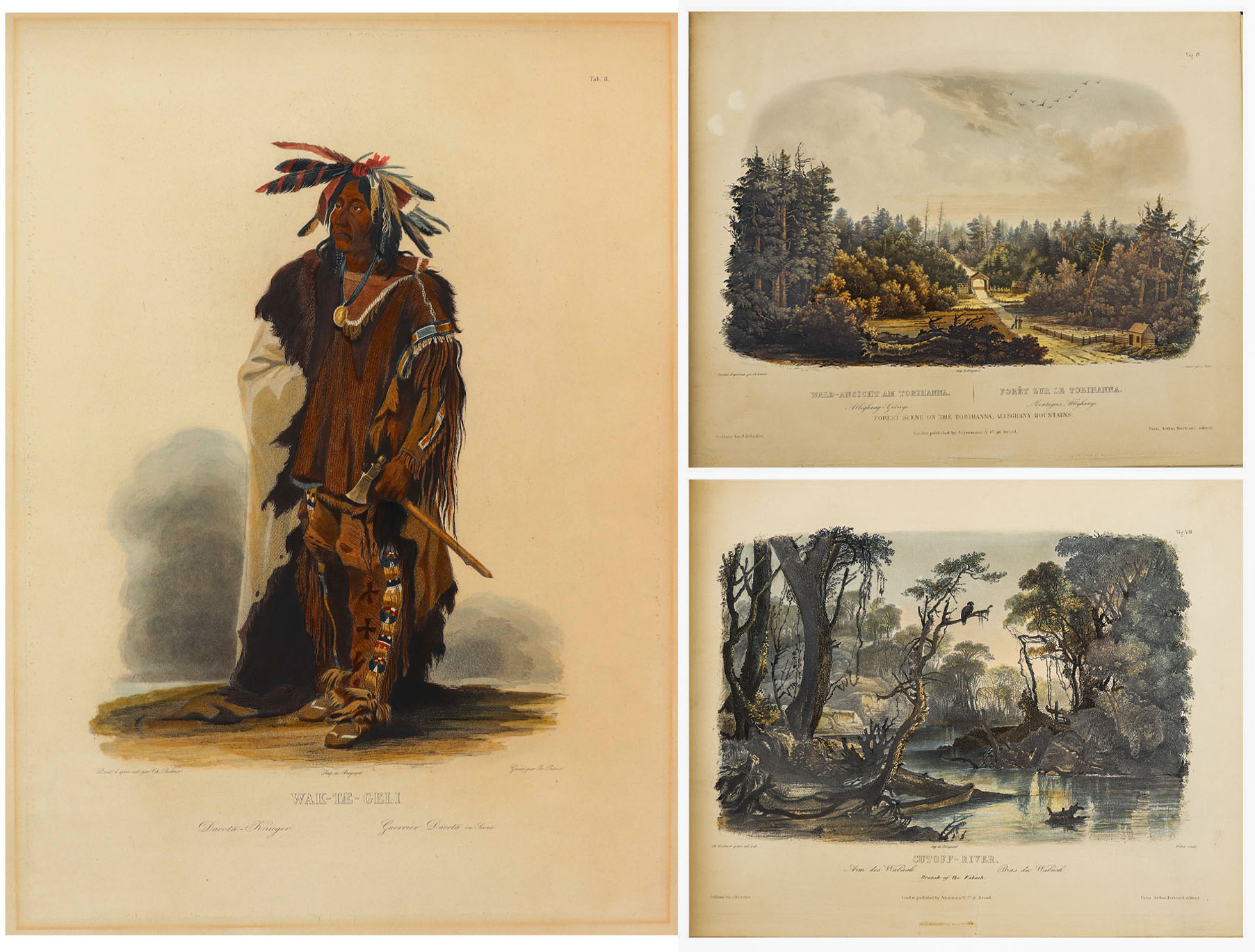
Karl Bodmer Prince of Wied’s Travels in the Interior
Stunningly beautiful collection of 81 hand-colored aquatints by the Swiss artist Karl Bodmer, a complete collection from the illustrated travelogue, “Prince of Wied’s Travels in the Interior of North America”. Bodmer, who journeyed with the German Prince Maximilian of Wied-Neuwied from 1833-34 along the Missouri River, produced what is considered the best depictions of the indigenous peoples and landscapes during the frontier era, an America then still unspoiled by western migration. Of the Native American tribes of the Great Plains that they encountered, Bodmer’s depictions of the Blackfeet and Mandan tribes are especially important as the populations of these tribes were greatly affected by the smallpox epidemic of 1837, thus making Bodmer’s work the last visual testament to their culture.
Prince Max, as he was called, chose Bodmer to accompany him on the expedition along the Missouri River to visually depict the scenes that the Prince would write about. The result is this collection: three volumes of text by the Prince and two volumes of aquatints by Bodmer, in the first Paris edition published by Chez Arthus Bertrand, 1840-43 (“Voyage dans l’interieur de l’Amerique du Nord”). Text volumes in French also include 37 wood-engraved illustrations, only lacking the map in completeness. The two complete volumes of illustrations include the large folio volume with 48 oversized hand-colored aquatints measuring approximately 24.5″ x 18″, and the quarto volume with 33 hand-colored aquatints measuring approximately 12.5″ x 10.25″. The complete set of 81 aquatints is magnificent in their display, a time capsule with their hand-coloring evoking the sense of awe and discovery of the expedition. All volumes are bound in half black morocco and blue paper-covered boards with gilt accenting, and with black morocco labels to illustrated volumes. Minor handling wear to volumes, with a few small repaired tears to plates, some plates supplied with variance to margins, minute toning and foxing, a few plates beginning to separate from binding. Overall a very good plus set with excellent display quality. Sold for $175,000.


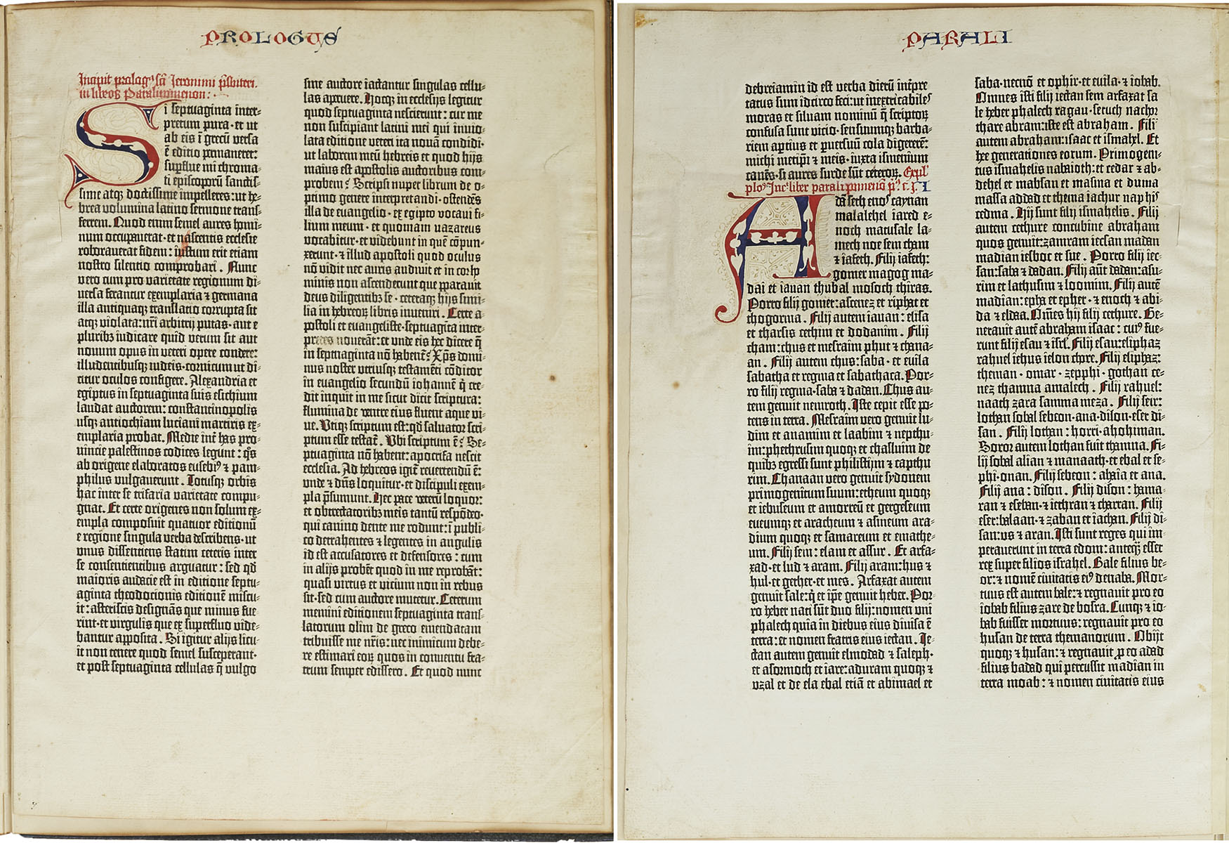
Gutenberg Bible Leaf 193 Chronicles of Old Testament
Scarce leaf from the Gutenberg Bible, one of the earliest major books printed from moveable metal type, the invention that ushered in the Age of Enlightenment by democratizing knowledge through mass production of literature. Printed by Johannes Gutenberg in Mainz, Germany from 1450-1455, less than 50 complete or near-complete copies of the Gutenberg Bible are now extant, with nearly all those housed in public institutions. Singular leaves are also scarce, with the leaf presented here having been acquired by bookseller Gabriel Wells, whose purchase of an incomplete Bible in 1920 gave way to selling the individual leaves alongside an essay by A. Edward Newton entitled “A Noble Fragment”. Leaf is number 193 of the full Latin Bible, with the recto being the Prologue to 1 Chronicles of the Old Testament, and the verso the first part of Chapter 1 of 1 Chronicles. Each page features two columns of 42 lines in dark black Gothic type, accented by red and blue rubrication. Each copy of the Gutenberg Bible differs in its rubrication and illumination, with buyers at the time deciding upon these embellishments after the Bible was printed. The six-line rubricated letters of this leaf were likely added later, restored to match the original style. Leaf measures 11.125″ x 15.375″, bound on edge to portfolio measuring 11.75″ x 16″. Paper quality is still bright with very little foxing or discoloration compared to other examples. A stunning example from the book that changed the course of history. Sold for $136,500.
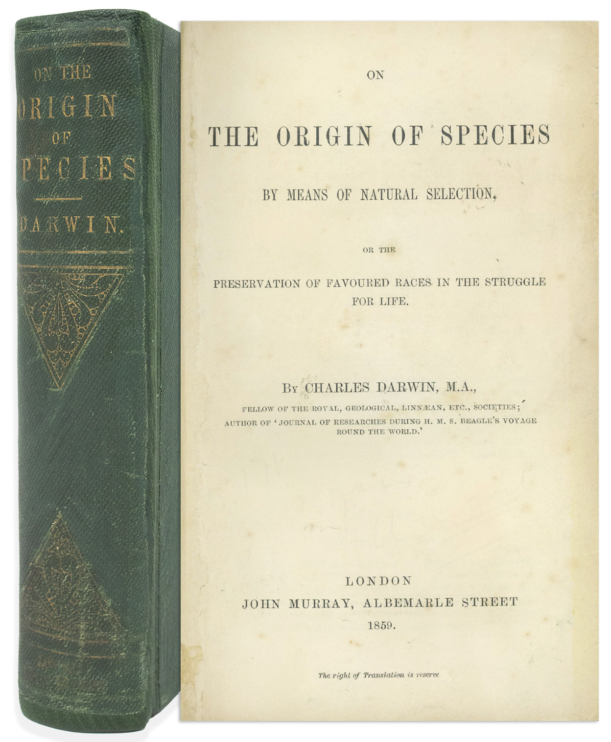
Charles Darwin On the Origin of Species 1st Edition
First edition, first printing of “On the Origin of Species” by Charles Darwin, one of the most important books in the scientific canon. London: John Murray, 1859. In this revolutionary book that upended man’s own view of himself, Darwin posits natural selection as the engine driving species’ evolution, an argument so persuasive that even 19th century religious leaders adjusted their teachings to allow for evolution to work in concert with divine planning. Its importance has only grown in the 150+ years since publication, with Freeman concluding it to be “the most important biological book ever written”. First released on 24 November 1859, its scarcity nearly matches its importance, with the first printing consisting of only 1,250 copies, and the number of extant copies now significantly fewer.
All first printing points are present, including original binding, variant B, title page with copyright information on verso, Table of Contents (pages v-ix) with binder instructions to verso, complete pages 1-502, and folding table present between pages 116-117. Bound in publisher’s full green boards, stamped and lettered in gilt. Overall in very good condition; ads at back of volume have been removed as has half-title page, and endpapers have been replaced. Volume is rebacked using morocco, with original spine laid down. Some shelf wear to boards. Light foxing throughout book, with some chipping, small closed tears with repairs to a few pages, and a few dogeared pages. One small mark on page 109, otherwise no internal writing or marks. Housed in a custom quarter-leather clamshell box. Overall in very good condition, a handsome, presentable copy of this scarce first printing. Sold for $68,250.
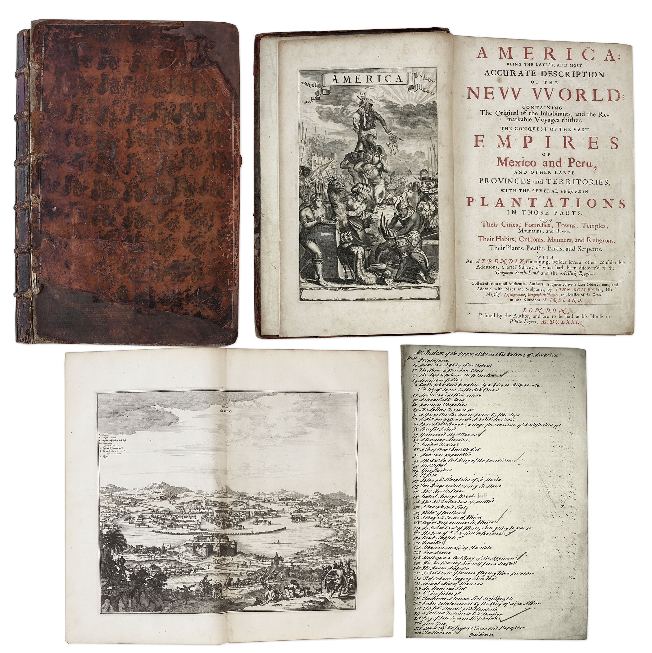
One of the most important books on the history of America (cited by Borba de Moraes, Howes, Sabin and Wing), the 1671 first edition of ”America: Being the Latest and Most Accurate Description of the New World”. Privately printed in London by the author, Arnoldus Montanus, and edited by John Ogilby. In ”America” Montanus goes into great detail of the new continents, with dozens of engravings of Native Americans, species of animals and reptiles, and the landscapes and settlements in the new world, accompanied by text. The book covers speculation regarding the earliest voyages to America, along with later recorded voyages and the settlements of New Netherlands/New York, New England, Hudson’s Bay, Labrador, Canada, Nova Scotia, Maryland, Virginia, (including Captain Smith’s capture and rescue by Pocahontas), Carolinas, Florida and California, plus accounts of Mexico and nearby islands, even including Australia and New Zealand. 674pp. book contains 75 original engravings (64 copper plates within the text and 9 plates throughout), lacking the maps and 28 engravings, which is typical as this edition is almost never found with all plates intact. All text is complete except for missing pages 445-446. Large format book measures 10” x 15”. Bound in original full leather boards, with some loss of leather to covers, cracking along spine and front board detached. Interior text is near fine and very readable. An important and fascinating addition to early knowledge of the American continent. Sold for $9,375.
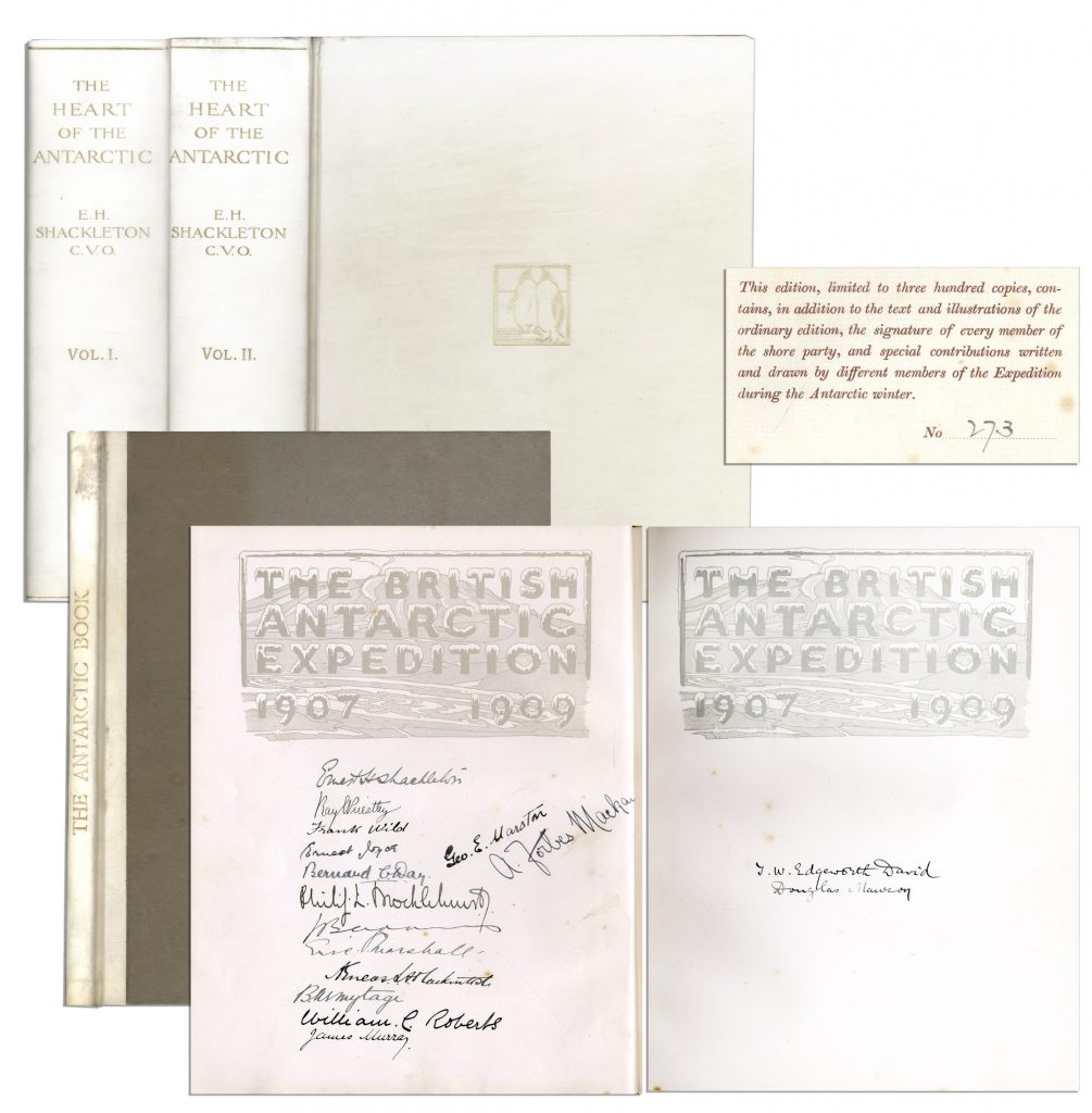
Ernest Shackleton & Crew Signed “The Heart of the Antarctic. Being the Story of the British Antarctic Expedition 1907-1909” Limited to Just 300 Copies, This Being All Three Volumes — Scarce
Ernest Shackleton’s signed copy of “The Heart of the Antarctic. Being the Story of the British Antarctic Expedition 1907-1909, 3 volumes (including “The Antarctic Book Winter Quarters 1907-09”), limited to 300 copies (here #273), also with signatures of the entire Shore party. Photogravure frontispiece, numerous plates (including 6 etched plates by George Marston, 16 tipped-in color after George Marston, others mostly photographic), one folding panorama and three folding lithographed maps in pocket at the end of volume three, illustrations and diagrams in the text. In publisher’s vellum, blocked in gilt with design of two penguins and top edges gilt. Occasional light spotting and small tear on cover of volume two. Overall in very good to near fine condition, signed by the Nimrod Shore Party crew. Sold for $12,718.
Revolutionary War Map 1776
Revolutionary War map dated March 1776. “The Theatre of War in North America, With the Roads and a Table of the Distances…” Printed in London for R. Sayer and J. Bennett. Map depicts the area east of the Mississippi River from James Bay to Cape Canaveral, and locates provincial boundaries, towns, forts, roads, Indian villages, New England fishing waters, and the like. An inset is comprised of “Evan’s Polymetric Table of America,” which allows one to calculate the distance between most of the prominent towns. Text below the map reads, “A Compendious Account of the British Colonies in North America,” which devotes a paragraph of description to each of the North American colonies, including Florida, Canada, and the Province of Quebec. Issued separately by Sayer and Bennett, who also published “the American Military Pocket Atlas,” that year for the use of British officers. A notable map of the American Revolution, published the same year as the American Declaration of Independence. 20.75″ x 28.5″; 29.25″ x 37.5″ framed. Excellent condition. Sold for $6,000.

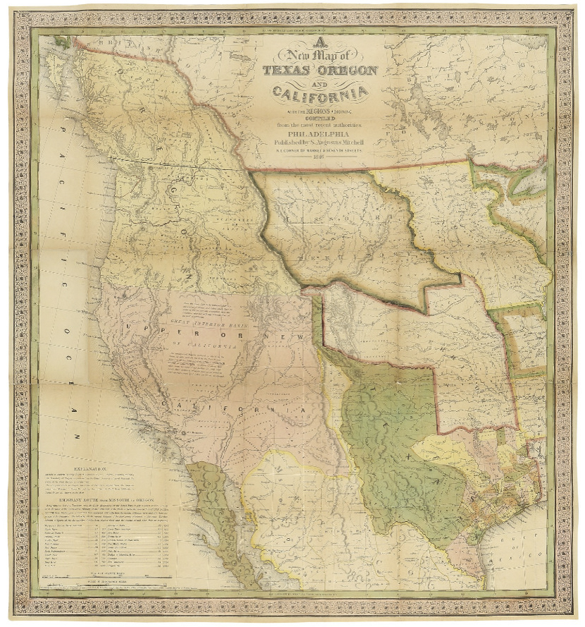
Map of Texas, Oregon and California From 1846
“A New Map of Texas Oregon and California with the Regions Adjoining. Compiled from the most recent authorities.” By cartographer Samuel Augustus Mitchell, published in 1846 as a pocket map, and considered the definitive map for settlers in the nation’s westward expansion during the Gold Rush. Philadelphia: Published by S. Augustus Mitchell, 1846. With contemporary hand-coloring, folding map by engraver H.N. Burroughs was Mitchell’s most important map, considered the defacto standard and thereby affecting subsequent maps of the area. It was the first to include recent explorations in the Great Basin, with boundary lines of Rio Grande to the south, and Oregon to the north at 54 degrees 40 minutes, above which are “British Possessions”. An inset to lower left entitled “Emigrant Route from Missouri to Oregon”, provides the distance between western cities and landmarks, undoubtedly aiding weary travelers. With decorative scrollwork along the margins, map measures 21″ x 22.5″ unfolded, nicely matted and framed to a size of 34.5″ x 41.5″. Some expert repair at fold separations and mild fading, overall in very good condition. Sold for $4,800.
Lotter New and Correct Map of North America 1784
Large four-sheet engraved map measuring nearly 4′ x 3.5′ showing North America in 1784, with sovereignty of the thirteen colonies belonging to the United States following the Treaty of Paris that concluded the Revolutionary War. Published in Ausburg, Germany by Mathew Albert Lotter and Georg Frederic Lotter, 1784. Map is titled at upper right, “A new and correct map of North America with the West India Islands. Divided according to the last Treaty of Peace, concluded at Paris the 20th of Jan. 1783. wherein are particularly distinguished the Thirteen Provinces wich [sic] compose the United States of North America”. A cartouche underneath shows tradesmen and workers on the banks of Bermuda, and two insets show Baffin and Hudson’s Bay beneath the Arctic, and land bordering the “Sea of California” partially described as “The Passage by Land to California”. Map measures 46.875″ x 41″. Professionally backed to linen and lightly mounted to board. Minute foxing and a few spots of repair. Overall very good to near fine condition given age including superior color contrast. With fascinating detail, map would anchor a room and serve as an excellent topic of ongoing reflection and discussion. Sold for $1,750.

FREE APPRAISAL. To appraise, auction, buy, consign or sell your Nicolas de Nicolay Le Navigationi et Viaggi nella Turchia 1580 that is for sale, please email your description and photos of your Nicolas de Nicolay Le Navigationi et Viaggi nella Turchia 1580 to [email protected] of Nate D. Sanders Auctions (http://www.NateDSanders.com).