Sell or Auction Your New Map of The North Parts of America Claimed by France for up to $3,200 or More at Nate D. Sanders Auctions
FREE ESTIMATE. To buy, auction, sell or consign your New Map of the North Parts of America claimed by France that is for sale, please email your description and photos to [email protected] of Nate D. Sanders Auctions (http://www.NateDSanders.com).
Sell Your New Map of the North Parts of America Claimed by France
We sold a New Map of the North Parts of America claimed by France. Please see details below:
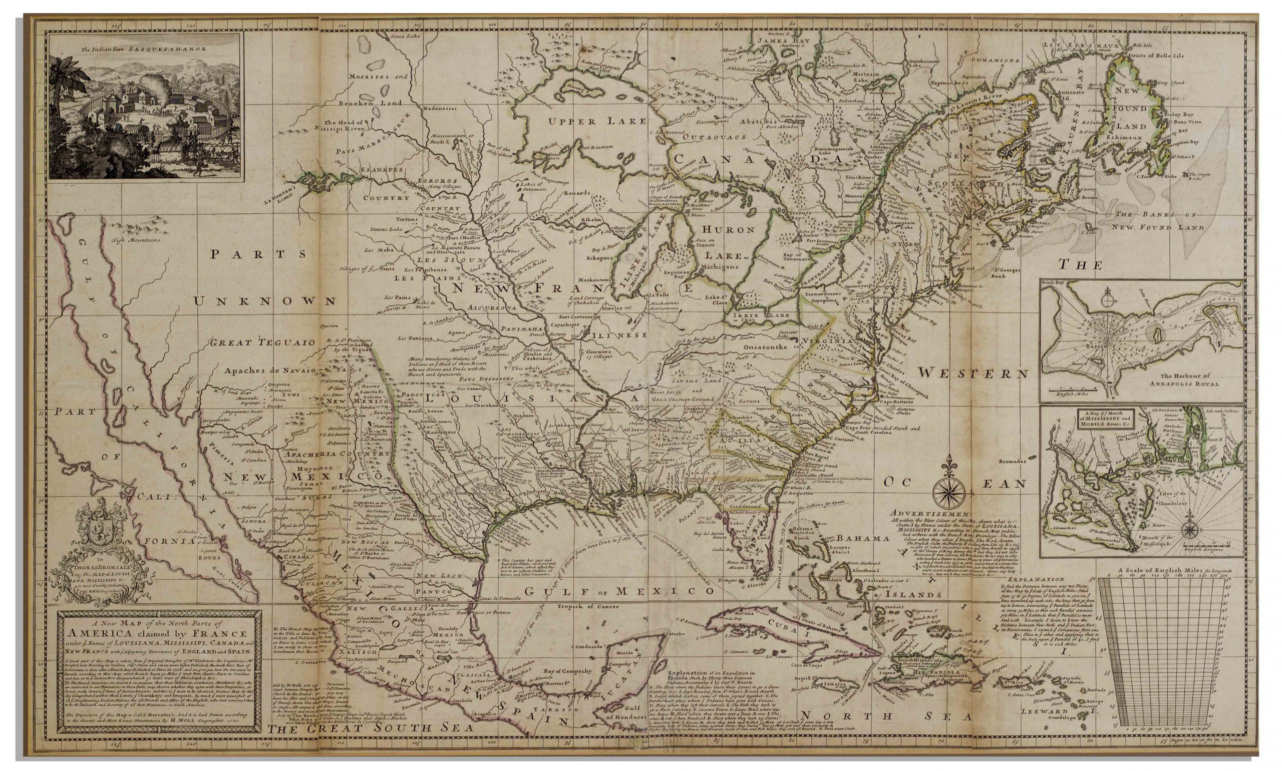
Americas Map Published in 1720 by London Cartographer Herman Moll — Measures 25″ x 40.75″
Large map of the Americas, published in 1720 by London cartographer Herman Moll entitled “A New Map of the North Parts of America claimed by France under ye names of Louisiana, Mississipi, Canada and New France with ye adjoyning territories of England and Spain”. Engraved map incorporates the latest surveying of the Americas, such as a French expedition into Texas in 1716. Map is hand-colored at boundaries, featuring a vignette at upper left of “The Indian Fort Sasquesahanok”, and with various “Explanations” of the map printed at bottom, including one of an Indian expedition into Florida, “6 days Rowing”. Insets of the Annapolis Harbor and the mouths of the Mississippi and Mobile Rivers are also included. Map is published in four vertical sections, laid down on archival paper and mounted on board. Map measures 25″ x 40.75″. Minor browning at section lines and a few spots of buckling. An attractive map in very good condition, giving historical insight into the jockeying for land among the major European powers in the early 18th century. Sold for $3,200.
The following are some additional maps we sold:
Revolutionary War Map 1776
Revolutionary War map dated March 1776. “The Theatre of War in North America, With the Roads and a Table of the Distances…” Printed in London for R. Sayer and J. Bennett. Map depicts the area east of the Mississippi River from James Bay to Cape Canaveral, and locates provincial boundaries, towns, forts, roads, Indian villages, New England fishing waters, and the like. An inset is comprised of “Evan’s Polymetric Table of America,” which allows one to calculate the distance between most of the prominent towns. Text below the map reads, “A Compendious Account of the British Colonies in North America,” which devotes a paragraph of description to each of the North American colonies, including Florida, Canada, and the Province of Quebec. Issued separately by Sayer and Bennett, who also published “the American Military Pocket Atlas,” that year for the use of British officers. A notable map of the American Revolution, published the same year as the American Declaration of Independence. 20.75″ x 28.5″; 29.25″ x 37.5″ framed. Excellent condition. Sold for $6,000.

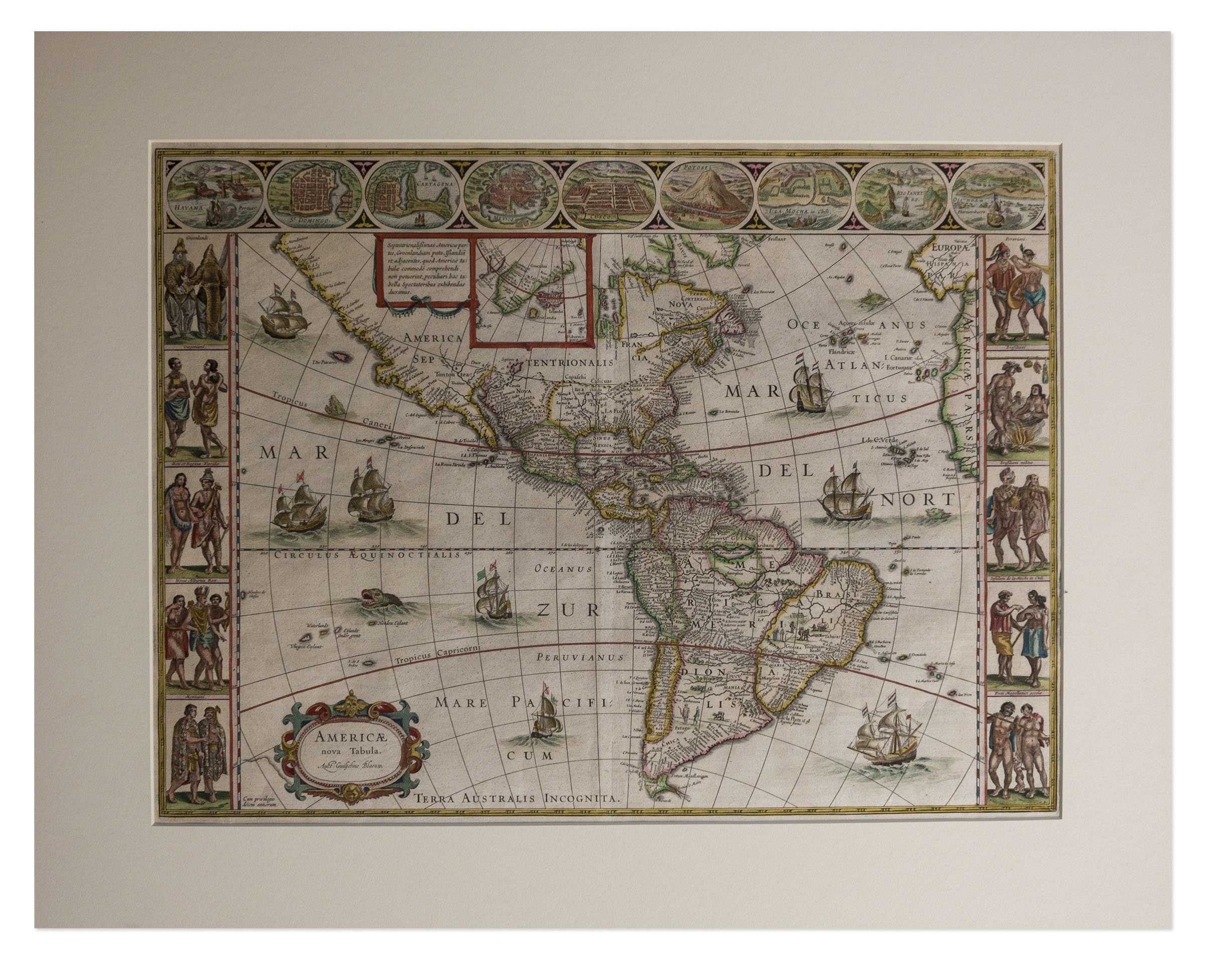
17th Century Hand-Colored Map of the Americas by Noted Cartographer Willem Blaeu — Entitled “A New Map of America”
One of the few maps of the Americas by renowned 17th century Dutch cartographer Willem Blaeu, published in Amsterdam, circa 1640s, entitled “Americae Nova Tabula” or “A New Map of America”. Hand-colored engraved map is accentuated with a sea monster and galleon ships in the body of the map, with Blaeu further decorating the side borders with semi-nude and costumed figures, and the top border with geographical areas such as Mexico and Havana. Of this particular map, the expert Philip Burden has stated, “This is one of only a few maps relating to North America by Blaeu. Its visual appeal is enhanced greatly by the inclusion of three decorative borders. These are drawn from various sources, including Theodore de Bry.” Map measures 23.75″ x 19.25″, matted to 28″ x 22.25″. French text printed on verso. Mild, uniform toning and archival repair to verso, overall in exceptional near fine condition given age. Sold for $4,000.
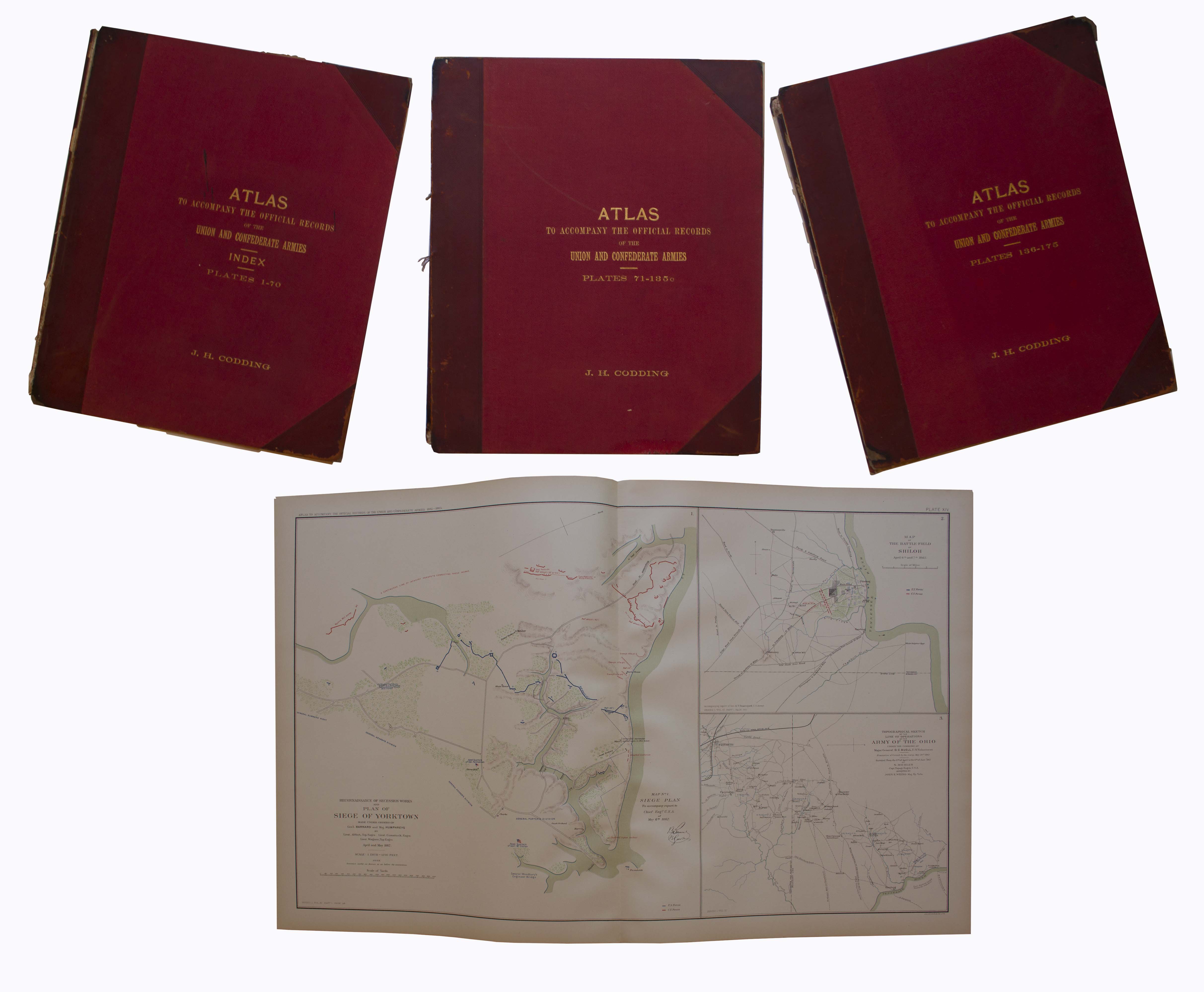
Three volume set of the ”Atlas to Accompany the Official Records”, compiled by Capt. Calvin D. Cowles. Washington, D.C.: U.S. Government Printing Office, 1891-1895. This three volume set of maps and drawings was printed to accompany the most comprehensive primary reference for the Civil War: ”War of the Rebellion: Official Records of the Union and Confederate Armies”, published by the U.S. Government in 53 volumes. All 175 plates are present here, with detailed schematics of battlegrounds, troop movements, examples of uniforms, transportation methods etc. Set is bound in original three-quarter red leather and maroon cloth, with marbled endpapers. Separated front board on Vols. 1 and 2, scuffing to boards and some loss to leather of spines, especially on Vol. 1. Maps and drawings, however, are in very good to near fine condition, with virtually no toning. Sold for $2,000.
Consign your New Map of the North Parts of America claimed by France at Nate D. Sanders Auctions. Send a description and images of your New Map of the North Parts of America claimed by France to us at [email protected].
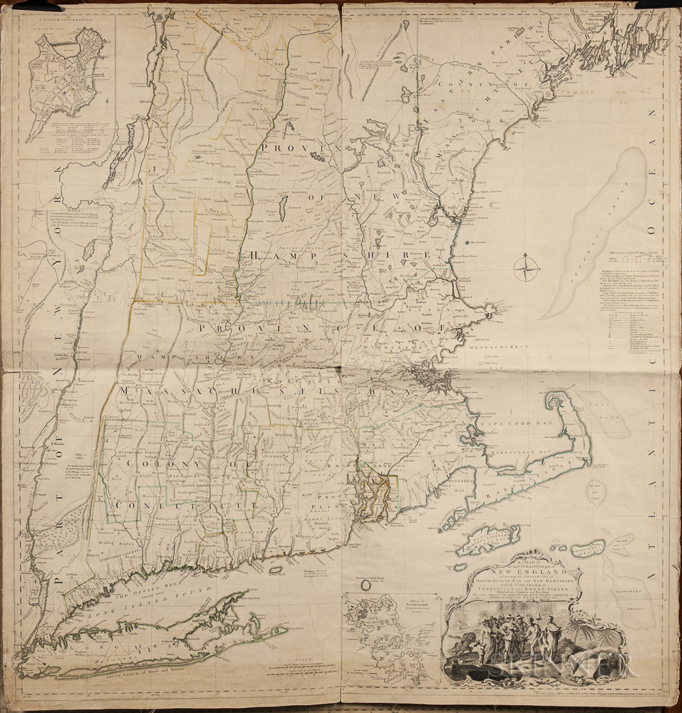
1774 Map of New England measuring over 40” square, the earliest large scale map of the New England colonies and used in the American Revolution. Drawn by Braddock Mead, and originally published in 1755, this copy was included in Thomas Jefferys’ ”American Atlas”, with hand-outlines. London: Printed and sold by R. Sayer and J. Bennett, 1776 (map dated 1774). Entitled in full, ”A Map of the Most Inhabited Part of New England Containing the Provinces of Massachusetts Bay and New Hampshire, with the Colonies of Connecticut and Rhode Island, Divided into Counties and Townships: The whole composed from Actual Surveys and its Situation adjusted by Astronomical Observations.” Measures 40” x 41.25”. Folded in fourths, as printed by copper-plate engraving on laid paper, mounted to linen. Light toning, chipping along margins and separation starting along folds. Overall in very good condition, a bright copy ideal for framing. Sold for $1,875.
FREE ESTIMATE. To buy, auction, sell or consign your New Map of the North Parts of America claimed by France that is for sale, please email your description and photos to [email protected] of Nate D. Sanders Auctions (http://www.NateDSanders.com).
We offer the following services for your New Map of the North Parts of America claimed by France:
- Appraise New Map of the North Parts of America claimed by France.
- Auction New Map of the North Parts of America claimed by France.
- Consign New Map of the North Parts of America claimed by France.
- Estimate New Map of the North Parts of America claimed by France.
- Sell New Map of the North Parts of America claimed by France.
- New Map of the North Parts of America claimed by France valuation.
- New Map of the North Parts of America claimed by France consignment.