Skip to content
nate d sanders auctions logo
  • AuctionExpand
    • Current Auction
    • Instructions
  • Register
  • ConsignExpand
    • Consign With Us
    • Noteable Estates & Testimonials
  • Prices Realized
  • Blog
  • In The News
  • My Account
  • Contact
Facebook X YouTube Linkedin
nate d sanders auctions logo
Home » Uncategorized
Uncategorized

Sell or Auction Your Massachussets Bay Colony Map Ink on Vellum 17th c for up to Nearly $10,000 or More at Nate D. Sanders Auctions

ByNate D Sanders April 7, 2022April 7, 2022

Consign With Us

Do you have a high-value item that you would like to get the maximum price possible? If so, please call us at (310) 440-2982 or use the form below. A representative of Nate D. Sanders Auctions will contact you concerning your items.

Attach up to 4 pictures in gif, jpg or png format not to exceed 4Mb.

There are two methods to select your images after you clicking “Choose Files”:

While holding the Shift Key down, select the first image and the last image. All images between will be highlighted.

While holding the CTrl Key down, select each image one click at a time. Only the selected images will be chosen. Then click “Open” and the selected files will be included in the form.

You can also email us at [email protected]

FREE APPRAISAL. To buy, auction, sell or consign your Massachussets Bay Colony Map ink on vellum 17th c that is for sale, please email your description and photos to [email protected] of Nate D. Sanders Auctions (http://www.NateDSanders.com).

Sell Your Massachussets Bay Colony Map Ink on Vellum 17th c

Below is a recent realized price for a Massachussets Bay Colony Map ink on vellum 17th c item. We at Nate D. Sanders Auctions can obtain up to these amounts or more for you:

Massachussets Bay Colony Map Ink on Vellum 17th c. Sold for nearly $10,000.

Consign your Massachussets Bay Colony Map ink on vellum 17th c at Nate D. Sanders Auctions. Send a description and images of your item to us at [email protected].

Here are some recent items that our auction house, Nate D. Sanders (http://www.NateDSanders.com) has sold:

Meriwether Lewis 1807 Document Signed Related to the Famed Lewis & Clark Expedition — Lewis Receives 5 Months Pay From the Expedition Upon Returning to D.C. 

Very scarce Meriwether Lewis document signed ”Meriwether Lewis Capt. / 1st U’S. Regt. Infty.” Single octavo page, dated 12 February 1807 reads in full: ”Received February 12th 1807 of Caleb Swan Paymaster of the Army of the United States, Two hundred dollars, in pursuance of a warrant from General Henry Dearborn Secretary of War, No. 1003, being on account of my pay and subsistence, for which sum I am accountable to the Accountant of the Department of War, having signed duplicates hereof. 200 Drs.” In January 1803, President Thomas Jefferson sought to learn more about the far western territory, and appropriated the money from Congress for the proposed journey, to be led by the experienced explorer Meriwether Lewis. In his memoirs, Jefferson wrote of Lewis:  

”Of courage undaunted; possessing a firmness and perseverance of purpose which nothing but impossibilities could divert from its direction; careful as a father of those committed to his charge, yet steady in the maintenance of order and discipline; intimate with the Indian characters, customs, and principles; habituated to the hunting life; guarded by exact observations of the vegetables and animals of his own country against losing time in the description of objects already possessed; honest, disinterested, liberal, of sound understanding, and a fidelity to truth so scrupulous that whatever he should report would be as certain as seen by ourselves…” (”History of the Expedition,” 1814). In the months immediately preceding the expedition, Lewis sought training in the use of astronomical instruments and in the art of map-making. He also chose a companion officer, William Clark of Louisville. While the expedition did not achieve the primary objective of finding the elusive Northwest Passage, it contributed significantly to the understanding of the geography of the Northwest and produced approximately 140 maps, the first accurate maps of the area. In addition, it documented 100 newly discovered species of animals, approximately 170 plants, and it also established friendly relations with three dozen Indian tribes. The knowledge they obtained sparked American interest in the west, and strengthened the nation’s claim to the area. Meriwether Lewis returned to Washington, D.C. from his three year journey in late December of 1806. After returning from the expedition, Lewis received a reward of 1,600 acres of land. In addition, Thomas Jefferson appointed him Governor of the Louisiana Territory. However, Lewis was not confirmed by the Senate until March 1807 and he remained a Captain in the interim. Base pay for Captains at this period was $40 per month so the present receipt would represent five months’ salary. A supremely rare document directly linking Meriwether Lewis to the Lewis & Clark Expedition. Items of Lewis & Clark related to the famed expedition are of the utmost rarity. Docketed on verso. Toning to folds and showthrough, otherwise near fine condition.  Sold for $30,768.    

Massachussets Bay Colony Map ink on vellum 17th c
Meriwether Lewis 1807 Document Signed Related to the Famed Lewis & Clark Expedition. Click to enlarge.

Meriwether Lewis Signed Appointment as Governor of Louisiana From 1808 — Very Scarce Signature, Dated 2 Years After the Lewis & Clark Expedition

As Governor and Commander in Chief of Louisiana, Meriwether Lewis signs his full name in black ink to a document, appointing George Armistead to the position of ”Justice of the Peace for the township of Arkansas, District of New Madrid” on 18 May 1808. Armistead would later become the Commander of American forces during the bombardment of Fort McHenry in the War of 1812. Lewis’ signature is very scarce as he died of a gunshot wound in 1809, with few documents signed by him as Governor of Louisiana during his 2-year tenure. Document is also one of the few after his expedition from 1804-1806 with William Clark, which charted the newly acquired Louisiana Territory for the United States, a highly dangerous mission but successful mission. Document retains its paper-covered seal and is co-signed by Secretary Frederick Bates, who later became Governor of Missouri.  A great Lewis and Clark autograph. Measures 12.5” x 7.75”. Document has been archivally repaired at left panel, small tears at edges of folds, tape to top of left panel, overall very good condition.  Sold for $24,513.

Massachussets Bay Colony Map ink on vellum 17th c
click to enlarge

Very Scarce 1670 Pilgrim Land Deed — Signed by Several Prominent Pilgrims Including Nathaniel Morton, Constant Southworth & John Rogers

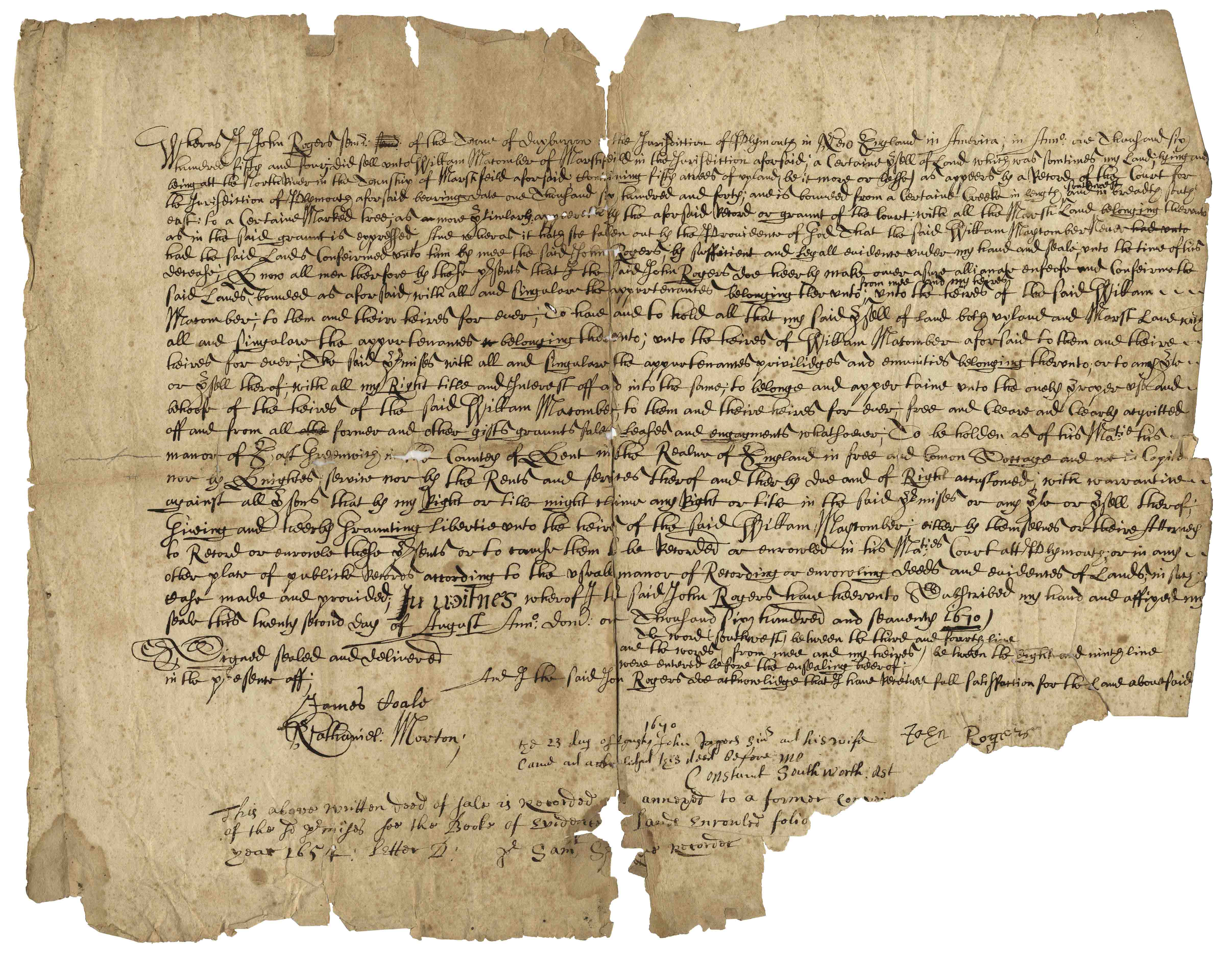
Beautiful and scarce Pilgrim document from 17th century colonial America. Dated 1670, document confirms the sale of 50 acres of land in Marshfield, Plymouth County, Massachusetts by John Rogers to William Macomber. Document is signed by a veritable who’s-who of Pilgrim notables, including Rogers, Nathaniel Morton, Constant Southworth and James Toale (Towle). In addition to writing the first historical text published in the United States (about the settlement of the Plymouth Colony) Nathaniel Morton was the first to publish a list of signers of the Mayflower Compact and also wrote his account of the first Thanksgiving. He served for most of his life as Secretary of Plymouth Colony, where his careful record-keeping enabled him to compile New England’s Memorial, considered the first comprehensive history of the colony, published at Cambridge in 1669, and widely considered the first book of history published in the United States. In fact, ”The Wall Street Journal” has published an excerpt from Morton’s history of Plymouth Colony as an op-ed the Wednesday before Thanksgiving Day since 1961. Constant Southworth came to Plymouth in 1628 as a teenager, and held several prominent positions during his life, including Treasurer of the Colony. John Rogers was born in 1642 in Plymouth County, the son of a Mayflower passenger. Document measures approximately 15.5” x 12” with some paper loss to lower right. Some expected foxing and toning, small amount of paper loss and archival tape repair to verso. In very good condition considering age, with still bold writing. Sold for $10,000.

John Hawkesworth James Cook Voyages
Very Scarce 1670 Pilgrim Land Deed. Click to enlarge.

Important 17th Century First Edition of “America: Being the Latest and Most Accurate Description of the New World” — Includes 75 Engravings of American Geography, Animals & Native People

One of the most important books on the history of America (cited by Borba de Moraes, Howes, Sabin and Wing), the 1671 first edition of ”America: Being the Latest and Most Accurate Description of the New World”. Privately printed in London by the author, Arnoldus Montanus, and edited by John Ogilby. In ”America” Montanus goes into great detail of the new continents, with dozens of engravings of Native Americans, species of animals and reptiles, and the landscapes and settlements in the new world, accompanied by text. The book covers speculation regarding the earliest voyages to America, along with later recorded voyages and the settlements of New Netherlands/New York, New England, Hudson’s Bay, Labrador, Canada, Nova Scotia, Maryland, Virginia, (including Captain Smith’s capture and rescue by Pocahontas), Carolinas, Florida and California, plus accounts of Mexico and nearby islands, even including Australia and New Zealand. 674pp. book contains 75 original engravings (64 copper plates within the text and 9 plates throughout), lacking the maps and 28 engravings, which is typical as this edition is almost never found with all plates intact. All text is complete except for missing pages 445-446. Large format book measures 10” x 15”. Bound in original full leather boards, with some loss of leather to covers, cracking along spine and front board detached. Interior text is near fine and very readable. An important and fascinating addition to early knowledge of the American continent. Sold for $9,375.

Massachussets Bay Colony Map ink on vellum 17th c
Important 17th Century First Edition of ”America: Being the Latest and Most Accurate Description of the New World’. Click to enlarge.

John White’s Map of Virginia From 1590 — The First Printed Map of Virginia and North Carolina

An important 16th century North American map known not only for its level of detail and accuracy, but also for its “firsts”: the first printed map of Virginia and North Carolina, the first to use Virginia in its title, the first to name the Chesapeake Bay, and also the first regional map showing the Roanoke Colony. Frankfurt: Theodor de Bry (engraver) for inclusion in his “Anglorum in Virginiam aduentus”, 1590.

Map is based on the work of cartographer, artist and explorer John White, one of the first settlers and Governor of the Roanoke Colony who, after sailing back to the Colony from England in 1587, had found all the colonists famously missing, their fate a mystery still unsolved. Philip Burden, who wrote the definitive reference book, “The Mapping of North America”, wrote of this map: “One of the most significant cartographical milestones in colonial North American history…the most accurate map drawn in the sixteenth century of any part of that continent.”

This full-sheet engraved map still retains its dark print, with the English Royal Arms at top left, and artistic touches throughout such as ships and sea monsters in the open ocean, and Native American canoeists in the inland waters. Map is the second state, with “C” laid over the “E” in Ehesepiooc. Map measures 16.675″ x 12.25″, nicely matted and framed to a size of 28″ x 23.5″. Expert repair to single vertical fold, and small area of repair to lower right corner, just touching the edge of the ship, where paper loss has been replaced. Overall in very good to near fine condition given age, displaying beautifully. Sold for $6,665.

Phelps Ensign's New Travellers' Guide Map of the United States 1841
click to enlarge

Very Scarce 1814 First Edition of ”History of the Expedition” Lewis and Clark Account — With Five Engraved Maps — First Edition Account of Landmark Expedition

First edition, two-volume set of ”History of the Expedition under the Command of Captains Lewis and Clark to the source of the Missouri thence across the Rocky Mountains and down the river Columbia to the Pacific Ocean performed during the years 1804-05-06 by Meriwether Lewis and William Clark”. Published by Bradford and Inskeep: New York: 1814. Regarded as the definitive account of the first exhaustive, and most important Western exploration of America, which covered some eight thousand miles in slightly more than twenty-eight months. Lewis and Clark brought back the first reliable information about much of the area they traversed, made contact with the Native Americans as a prelude to the expansion of the fur trade, and advanced the geographical knowledge of the continent. This official account of the expedition is as much a landmark in Americana as the trip itself. Books, each measuring 5.5” x 8.75”, are bound in original marble-patterned leather boards and have five engraved, bound-in maps, missing the fold-out map found in some copies. Covers are worn and scuffed and the inside of covers have insect channels. Vol. I, 470pp., is missing the front free endpaper and has a chip out of the title page. Volume II runs 522pp. Light foxing and dampstaining throughout both volumes and some paper loss not affecting text. Overall in very good condition. An attractive set of America’s most important exploration narrative. Sold for $6,544.

Massachussets Bay Colony Map ink on vellum 17th c
Very Scarce 1814 First Edition of ”History of the Expedition” Lewis and Clark Account. Click image to enlarge.

Revolutionary War Map 1776

Revolutionary War map dated March 1776. “The Theatre of War in North America, With the Roads and a Table of the Distances…” Printed in London for R. Sayer and J. Bennett. Map depicts the area east of the Mississippi River from James Bay to Cape Canaveral, and locates provincial boundaries, towns, forts, roads, Indian villages, New England fishing waters, and the like. An inset is comprised of “Evan’s Polymetric Table of America,” which allows one to calculate the distance between most of the prominent towns. Text below the map reads, “A Compendious Account of the British Colonies in North America,” which devotes a paragraph of description to each of the North American colonies, including Florida, Canada, and the Province of Quebec. Issued separately by Sayer and Bennett, who also published “the American Military Pocket Atlas,” that year for the use of British officers. A notable map of the American Revolution, published the same year as the American Declaration of Independence. 20.75″ x 28.5″; 29.25″ x 37.5″ framed. Excellent condition. Sold for $6,000.

Revolutionary War Map 1776. Click to enlarge.

Map of Texas, Oregon and California From 1846

“A New Map of Texas Oregon and California with the Regions Adjoining. Compiled from the most recent authorities.” By cartographer Samuel Augustus Mitchell, published in 1846 as a pocket map, and considered the definitive map for settlers in the nation’s westward expansion during the Gold Rush. Philadelphia: Published by S. Augustus Mitchell, 1846. With contemporary hand-coloring, folding map by engraver H.N. Burroughs was Mitchell’s most important map, considered the defacto standard and thereby affecting subsequent maps of the area. It was the first to include recent explorations in the Great Basin, with boundary lines of Rio Grande to the south, and Oregon to the north at 54 degrees 40 minutes, above which are “British Possessions”. An inset to lower left entitled “Emigrant Route from Missouri to Oregon”, provides the distance between western cities and landmarks, undoubtedly aiding weary travelers. With decorative scrollwork along the margins, map measures 21″ x 22.5″ unfolded, nicely matted and framed to a size of 34.5″ x 41.5″. Some expert repair at fold separations and mild fading, overall in very good condition. Sold for $4,800.

Massachussets Bay Colony Map ink on vellum 17th c
click to enlarge

Herman Moll New Map of the North Parts of America

Large map of the Americas, published in 1720 by London cartographer Herman Moll entitled “A New Map of the North Parts of America claimed by France under ye names of Louisiana, Mississipi, Canada and New France with ye adjoyning territories of England and Spain”. Engraved map incorporates the latest surveying of the Americas, such as a French expedition into Texas in 1716. Map is hand-colored at boundaries, featuring a vignette at upper left of “The Indian Fort Sasquesahanok”, and with various “Explanations” of the map printed at bottom, including one of an Indian expedition into Florida, “6 days Rowing”. Insets of the Annapolis Harbor and the mouths of the Mississippi and Mobile Rivers are also included. Map is published in four vertical sections, laid down on archival paper and mounted on board. Map measures 25″ x 40.75″. Minor browning at section lines and a few spots of buckling. An attractive map in very good condition, giving historical insight into the jockeying for land among the major European powers in the early 18th century. Sold for $3,200.

Sylvanus Bernard Modern world map Venice Jacob Pentium 1511
Americas Map Published in 1720 by London Cartographer Herman Moll. Click image to enlarge.

Essential Civil War Reference, the ”Atlas to Accompany the Official Records” With All 175 Double-Page Plates, in Original Bindings

Three volume set of the ”Atlas to Accompany the Official Records”, compiled by Capt. Calvin D. Cowles. Washington, D.C.: U.S. Government Printing Office, 1891-1895. This three volume set of maps and drawings was printed to accompany the most comprehensive primary reference for the Civil War: ”War of the Rebellion: Official Records of the Union and Confederate Armies”, published by the U.S. Government in 53 volumes. All 175 plates are present here, with detailed schematics of battlegrounds, troop movements, examples of uniforms, transportation methods etc. Set is bound in original three-quarter red leather and maroon cloth, with marbled endpapers. Separated front board on Vols. 1 and 2, scuffing to boards and some loss to leather of spines, especially on Vol. 1. Maps and drawings, however, are in very good to near fine condition, with virtually no toning. Sold for $2,000.

John Speed A New and Accurat Map of the World
Essential Civil War Reference, the ”Atlas to Accompany the Official Records”. Click to enlarge.

1774 Map of New England — The First Large Scale Map of New England Used for the American Revolution — From Thomas Jefferys’ ”American Atlas”

1774 Map of New England measuring over 40” square, the earliest large scale map of the New England colonies and used in the American Revolution. Drawn by Braddock Mead, and originally published in 1755, this copy was included in Thomas Jefferys’ ”American Atlas”, with hand-outlines. London: Printed and sold by R. Sayer and J. Bennett, 1776 (map dated 1774). Entitled in full, ”A Map of the Most Inhabited Part of New England Containing the Provinces of Massachusetts Bay and New Hampshire, with the Colonies of Connecticut and Rhode Island, Divided into Counties and Townships: The whole composed from Actual Surveys and its Situation adjusted by Astronomical Observations.” Measures 40” x 41.25”. Folded in fourths, as printed by copper-plate engraving on laid paper, mounted to linen. Light toning, chipping along margins and separation starting along folds. Overall in very good condition, a bright copy ideal for framing. Sold for $1,875.

Massachussets Bay Colony Map ink on vellum 17th c
1774 Map of New England. Click to enlarge.

John Speed Map of New England and New York 1676

The most famous 17th century map of New England, engraved by cartographer Francis Lamb with Anglican names for the first time reflecting the shift from Dutch to English rule, such as New York rather than New Amsterdam and “New Jarsey”. London: Basset and Chisswell, 1676, from the reissue of John Speed’s atlas, “The Theatre of the Empire of Great Britaine”, with new maps of the English colonies. Colorful double-page map entitled “A Map of New England and New York”, shows wildlife of the area in addition to topography and boundary lines. With English text on verso headlined, “The Description of New Neatherlands [sic] now called NEW-YORK” and “The Description of New England”. Engraved map measures 21″ x 17.125″, hinged at top to mat measuring 26.375″ x 21.375″. Slight offset along center fold, tape repair to verso, small separation at top center fold, and minute foxing. Overall very good plus condition. Sold for $1,800.

John Winthrop signed Massachusetts land document
click to enlarge

Lotter New and Correct Map of North America 1784

Large four-sheet engraved map measuring nearly 4′ x 3.5′ showing North America in 1784, with sovereignty of the thirteen colonies belonging to the United States following the Treaty of Paris that concluded the Revolutionary War. Published in Ausburg, Germany by Mathew Albert Lotter and Georg Frederic Lotter, 1784. Map is titled at upper right, “A new and correct map of North America with the West India Islands. Divided according to the last Treaty of Peace, concluded at Paris the 20th of Jan. 1783. wherein are particularly distinguished the Thirteen Provinces wich [sic] compose the United States of North America”. A cartouche underneath shows tradesmen and workers on the banks of Bermuda, and two insets show Baffin and Hudson’s Bay beneath the Arctic, and land bordering the “Sea of California” partially described as “The Passage by Land to California”. Map measures 46.875″ x 41″. Professionally backed to linen and lightly mounted to board. Minute foxing and a few spots of repair. Overall very good to near fine condition given age including superior color contrast. With fascinating detail, map would anchor a room and serve as an excellent topic of ongoing reflection and discussion. Sold for $1,750.

New Correct Map North America West India Islands
click to enlarge

18th Century Hand-Painted Map of Korea by Japanese Artist Hayashi Shihei — Banned by the Shogun in 1792

Hand-painted map of Korea by Hayashi Shihei, from Japan, circa 1785. Fold-out map shows the kingdoms outside Japan’s boundaries, but with the Kingdom of Joseon (Korea) being an important trading partner, the map was considered dangerous, and consequently banned by the Shogun in 1792. Has original cover boards and title slip. Measures 20” x 29” when folded out, and 7” x 9.5” when closed. Lightly toned and soiled, overall very good condition. Sold for $1,563.

Massachussets Bay Colony Map ink on vellum 17th c
18th Century Hand-Painted Map of Korea by Japanese Artist Hayashi Shihei. Click to enlarge.

FREE ESTIMATE. To buy, auction, sell or consign your Massachussets Bay Colony Map ink on vellum 17th c that is for sale, please email your description and photos to [email protected] of Nate D. Sanders Auctions (http://www.NateDSanders.com).

Related Posts

  • Sell or Auction Your 2021 Tampa Bay Lightning Stanley Cup Ring for up to Over $25,000
  • Sell or Auction Your 1999 New York Yankees World Series Ring for up to Over $30,000 or More at Nate D. Sanders Auctions
  • Sell or Auction Your Opening Day 1947 Marble Rotunda Ticket for up to About $300,000 or More at Nate D. Sanders Auctions
Follow the latest on art, autographs, memorabilia, movie memorabilia, space memorabilia & sports memorabilia.

© 2026 Hollywood Memorabilia, Fine Autographs, & Consignments Blog

Consign With Us

Do you have a high-value item that you would like to get the maximum price possible? If so, please call us at (310) 440-2982 or use the form below. A representative of Nate D. Sanders Auctions will contact you concerning your items.

Attach up to 4 pictures in gif, jpg or png format not to exceed 4Mb.

There are two methods to select your images after you clicking “Choose Files”:

While holding the Shift Key down, select the first image and the last image. All images between will be highlighted.

While holding the CTrl Key down, select each image one click at a time. Only the selected images will be chosen. Then click “Open” and the selected files will be included in the form.

You can also email us at [email protected]

  • Auction
    • Current Auction
    • Instructions
  • Register
  • Consign
    • Consign With Us
    • Noteable Estates & Testimonials
  • Prices Realized
  • Blog
  • In The News
  • My Account
  • Contact
Facebook X Instagram
Search