A Lewis and Clark Autograph or a Meriwether Lewis Autograph Alone is $30,000+
FREE ESTIMATE. To buy, auction, sell or consign your Meriwether Lewis autograph that is for sale, please email your description and photos to [email protected] of Nate D. Sanders Auctions (http://www.NateDSanders.com).
Lewis and Clark Autograph
A Lewis and Clark autograph is very rare together, valued up to $75,000 for a Lewis and Clark autograph on one document or letter. Separately, their autographs are a different story. Meriwether Lewis died at just age 35, so his autograph is scarce and pricey. William Clark lived a fuller life and his autograph is only worth in the hundreds of dollars. Here are some great Lewis and Clark autograph items that we have sold including a Thomas Jefferson letter regarding them:
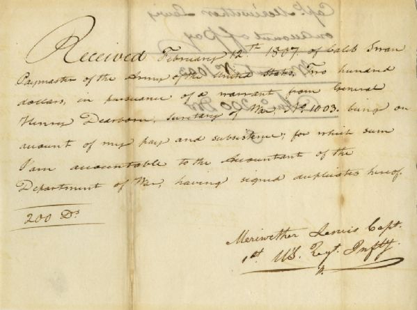
Very scarce Meriwether Lewis document signed ”Meriwether Lewis Capt. / 1st U’S. Regt. Infty.” Single octavo page, dated 12 February 1807 reads in full: ”Received February 12th 1807 of Caleb Swan Paymaster of the Army of the United States, Two hundred dollars, in pursuance of a warrant from General Henry Dearborn Secretary of War, No. 1003, being on account of my pay and subsistence, for which sum I am accountable to the Accountant of the Department of War, having signed duplicates hereof. 200 Drs.” In January 1803, President Thomas Jefferson sought to learn more about the far western territory, and appropriated the money from Congress for the proposed journey, to be led by the experienced explorer Meriwether Lewis. In his memoirs, Jefferson wrote of Lewis: ”Of courage undaunted; possessing a firmness and perseverance of purpose which nothing but impossibilities could divert from its direction; careful as a father of those committed to his charge, yet steady in the maintenance of order and discipline; intimate with the Indian characters, customs, and principles; habituated to the hunting life; guarded by exact observations of the vegetables and animals of his own country against losing time in the description of objects already possessed; honest, disinterested, liberal, of sound understanding, and a fidelity to truth so scrupulous that whatever he should report would be as certain as seen by ourselves…” (”History of the Expedition,” 1814). In the months immediately preceding the expedition, Lewis sought training in the use of astronomical instruments and in the art of map-making. He also chose a companion officer, William Clark of Louisville. While the expedition did not achieve the primary objective of finding the elusive Northwest Passage, it contributed significantly to the understanding of the geography of the Northwest and produced approximately 140 maps, the first accurate maps of the area. In addition, it documented 100 newly discovered species of animals, approximately 170 plants, and it also established friendly relations with three dozen Indian tribes. The knowledge they obtained sparked American interest in the west, and strengthened the nation’s claim to the area. Meriwether Lewis returned to Washington, D.C. from his three year journey in late December of 1806. After returning from the expedition, Lewis received a reward of 1,600 acres of land. In addition, Thomas Jefferson appointed him Governor of the Louisiana Territory. However, Lewis was not confirmed by the Senate until March 1807 and he remained a Captain in the interim. Base pay for Captains at this period was $40 per month so the present receipt would represent five months’ salary. A supremely rare document directly linking Meriwether Lewis to the Lewis & Clark Expedition. Items of Lewis & Clark related to the famed expedition are of the utmost rarity. Docketed on verso. Toning to folds and showthrough, otherwise near fine condition. A great Lewis and Clark autograph. Sold for $30,768.
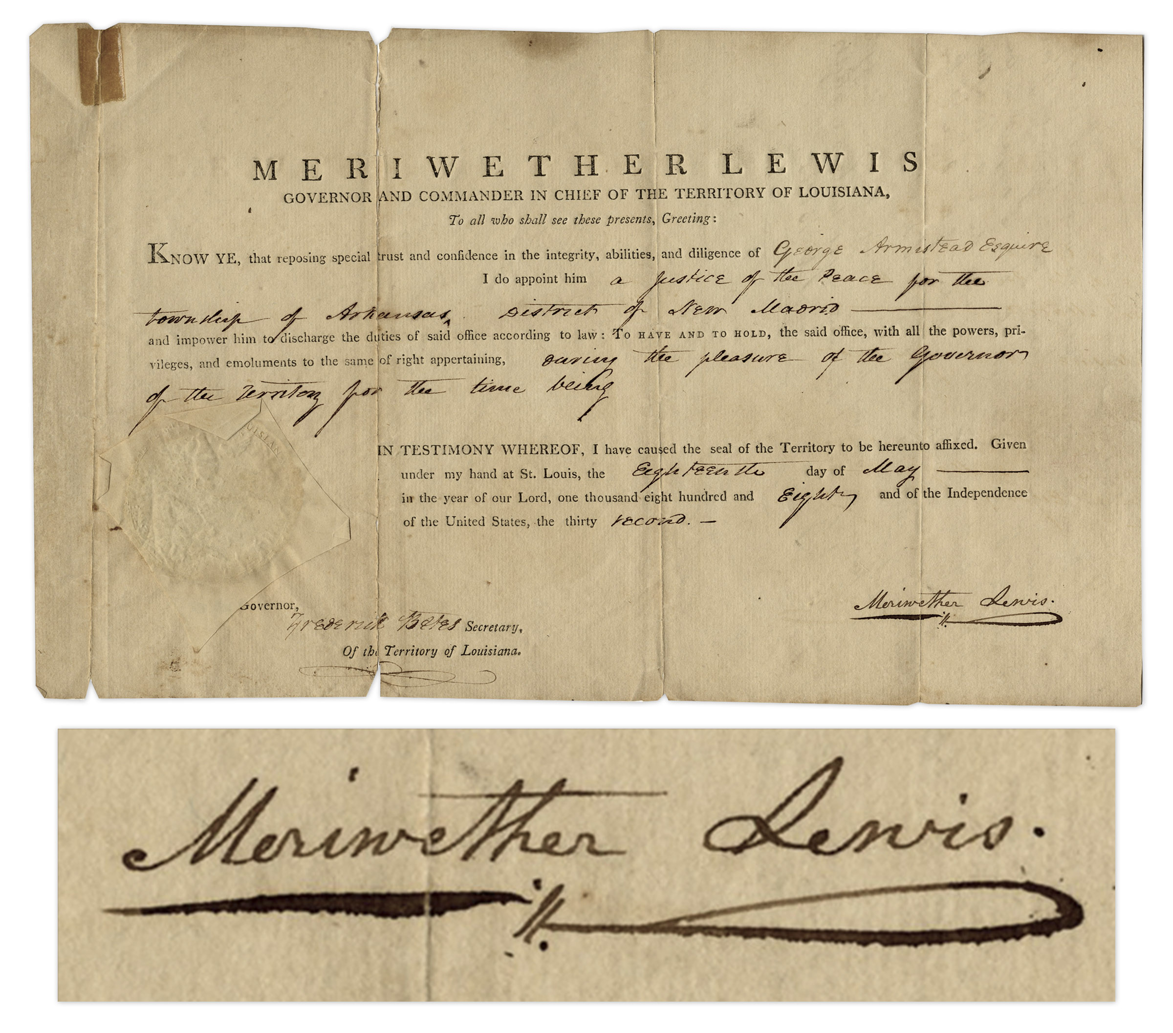
As Governor and Commander in Chief of Louisiana, Meriwether Lewis signs his full name in black ink to a document, appointing George Armistead to the position of ”Justice of the Peace for the township of Arkansas, District of New Madrid” on 18 May 1808. Armistead would later become the Commander of American forces during the bombardment of Fort McHenry in the War of 1812. Lewis’ signature is very scarce as he died of a gunshot wound in 1809, with few documents signed by him as Governor of Louisiana during his 2-year tenure. Document is also one of the few after his expedition from 1804-1806 with William Clark, which charted the newly acquired Louisiana Territory for the United States, a highly dangerous mission but successful mission. Document retains its paper-covered seal and is co-signed by Secretary Frederick Bates, who later became Governor of Missouri. A great Lewis and Clark autograph. Measures 12.5” x 7.75”. Document has been archivally repaired at left panel, small tears at edges of folds, tape to top of left panel, overall very good condition. Sold for $24,513.
Meriwether Lewis Autograph Letter Signed (W/o Clark)
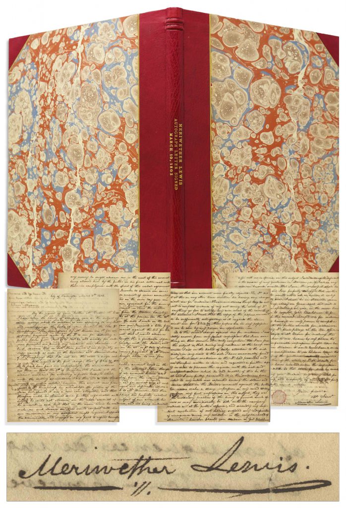
Meriwether Lewis autograph letter signed, composed in “City of Washington” on 10 March 1803, two months before he embarked on the Lewis and Clark Expedition. In this intriguing letter, written to the widow of a doctor, Lewis deflects on the issue of expenses incurred during his military service, debt that he believes should be paid by the federal government, writing in part, “I do not owe the estate a single cent.” Apparently, Lewis had ordered medical supplies from the widow’s husband, Dr. Alexander Humphreys, during Lewis’ time as an officer in Staunton, Virginia during the Quasi-War with France. Lewis believes that the federal government was responsible for reimbursement to the doctor, although the bills were never paid. Lewis would have the same issue years later as Governor of the Louisiana Territory, when an expedition he personally financed wasn’t reimbursed by the federal government; Lewis’ creditors then seized his assets, including land granted to him from the Lewis & Clark Expedition, contributing, it’s believed, to his probable suicide. Accompanied by full transcription, suggesting that Lewis did believe in his innocence, lengthy four page letter reads in part,
“Dear Madam, By the request of your brother Mr. Preston W. Brown I have taken the liberty of addressing you on the subject of certain moneys which he mentions as now appearing to my Debt, and unsatisfied on the books of your husband, the late Dr. Humphreys – The items stated by Mr. Brown are 1st for an improper payment made by the Dr. to me for subsisting a public horse from Nov. 96 to Nov. 99, and secondly for medicine furnished me during my residence near Staunton – I trust Madam that on both these points I can perfectly satisfy yourself as well as the Executors and Administrators of Dr. Humphreys that I do not owe the estate a single cent… “ Sold for $15,225.
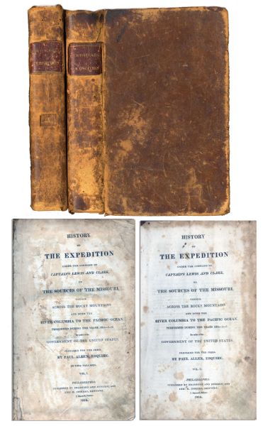
First edition, two-volume set of ”History of the Expedition under the Command of Captains Lewis and Clark to the source of the Missouri thence across the Rocky Mountains and down the river Columbia to the Pacific Ocean performed during the years 1804-05-06 by Meriwether Lewis and William Clark”. Published by Bradford and Inskeep: New York: 1814. Regarded as the definitive account of the first exhaustive, and most important Western exploration of America, which covered some eight thousand miles in slightly more than twenty-eight months. Lewis and Clark brought back the first reliable information about much of the area they traversed, made contact with the Native Americans as a prelude to the expansion of the fur trade, and advanced the geographical knowledge of the continent. This official account of the expedition is as much a landmark in Americana as the trip itself. Books, each measuring 5.5” x 8.75”, are bound in original marble-patterned leather boards and have five engraved, bound-in maps, missing the fold-out map found in some copies. Covers are worn and scuffed and the inside of covers have insect channels. Vol. I, 470pp., is missing the front free endpaper and has a chip out of the title page. Volume II runs 522pp. Light foxing and dampstaining throughout both volumes and some paper loss not affecting text. Overall in very good condition. An attractive set of America’s most important exploration narrative. Sold for $6,544.
Thomas Jefferson Handwritten Report as President Regarding the Lewis & Clark Expedition
Exceptional, museum-worthy report, handwritten by Thomas Jefferson as President, regarding the Lewis and Clark Expedition. Letter is addressed to William Jarvis of the U.S. consul in Lisbon, Portugal, dated 6 July 1805, describing the historic expedition that Jefferson authorized during his Presidency. In its entirety: “Sir / Since my letters of the 19th & 20th of July 1804 I have received your favors of Oct. 6 Nov. 14-25 Dec. 3 1806 & May 15 1805. As also some articles of fruits & for which I may you accept my acknowledgments. The pipe of Arruda vine came also safely to hand, and is indeed of very superior quality. I should be glad to receive always of exactly the same quality, adhering to the rule of putting no brandy to them. I had been for some time expecting your draught [draft] for the amount; but as you mention in your last that when you forward another pipe you will draw for both, I shall hold myself in readiness, and will be glad the vine would come out in autumn, so as to be here before the winter sets in. It gives me much pleasure to see a hope that Portugal may be able to preserve her neutrality. That a government so just & inoffensive should be forced into a war with which it has nothing to do shows the most profligate disregard to human rights. It is a great felicity to us and it secures all our other felicities, that so wide an ocean is spread between us & the lions & tygers of Europe, as enables us to go forward in the path of justice and independence fearing nothing but our creator. The great powers of Europe could do us injury by sea & on our shores. But the spirit of independence in the country at large they can never bend. We are now suffering from privateers on our coast, and are therefore fitting out a naval force to go & force them to keep a reasonable distance from our shores. Capt. Lewis who has been sent to explore the Missouri to its source & thence to pursue the nearest water communication to the South sea, passed the last winter among the savages 1600 miles up the Missouri. Deputies from the great nations in that quarter (2500 miles from hence) are now on their way to visit us. Lewis finds the Indians every where friendly. He will probably set back in 1806. Receipt my friendly salutations and assurances of respect.” Document measures 8″ x 10″ on two pages, with integral fly-leaf addressed to Jarvis in the hand of Jefferson’s secretary. Toning and folds throughout, with minor tape residue at top and a tiny chip at lower right corner. Near fine condition with bold, legible handwriting. An important piece of handwritten history by the President who commissioned America’s greatest exploration adventure. ADDITIONAL INFORMATION: A near exact copy of this letter resides in the Library of Congress’ Thomas Jefferson Papers. One of the two letters was produced by Jefferson’s polygraph machine (used from 1804 until his death), which provided an immediate copy of his handwritten letters. Though impossible to determine which copy was produced by the pen that Jefferson held, Jefferson typically kept the machine-produced letter as a copy for himself. Since this letter was mailed to William Jarvis (unlike the letter in the LOC), it’s probable that this letter was the one handwritten by Jefferson. It sold for $226,871.

FREE ESTIMATE. To buy, auction, sell or consign your Meriwether Lewis autograph that is for sale, please email your description and photos to [email protected] of Nate D. Sanders Auctions (http://www.NateDSanders.com).