Sell or Auction Your Henry Pelham Plan of Boston in New England 1777 for up to $300,000 or More at Nate D. Sanders Auctions
FREE ESTIMATE. To buy, auction, sell or consign your Henry Pelham Plan of Boston in New England 1777 that is for sale, please email your description and photos to [email protected] of Nate D. Sanders Auctions (http://www.NateDSanders.com).
Free Appraisal, Auction or Sell Your Henry Pelham Plan of Boston in New England 1777
Henry Pelham (February 14, 1748/49 – 1806) was an American painter, engraver, and cartographer active during the late 18th century. Pelham’s many illuminating letters, especially to his half-brother John Singleton Copley, provide an important contemporary perspective of the events of the American Revolution.
Below is a recent realized price for a Henry Pelham Plan of Boston in New England 1777 item. We at Nate D. Sanders Auctions can obtain up to this amount or more for you:
Henry Pelham Plan of Boston in New England 1777. Sold for $300,000.

The following is some historical memorabilia we sold:
Very scarce receipt signed by Paul Revere regarding one of his famous horseback rides, dated 15 February 1775 just two months before his Midnight Ride warning colonists that ”The British Are Coming” before the Battle of Lexington & Concord. As official courier for the Boston Committee of Public Safety, Revere was tasked with riding from Boston to Philadelphia and New York, with historians documenting 18 such rides from December 1773 to November 1775. This was likely the last of the rides before the Revolutionary War began, and is only one of two receipts for the rides ever to appear at auction, with the other selling at Christie’s for $140,000 in 2002. Composed entirely in the hand of Revere, receipt documents expenses ”from Boston to N. York” in the amount of 4 pounds, 3 shillings, and additional expenses for his Horse, and his time, all totaling 13 pounds, 19 shillings. Dated 15 February 1775 by Revere. Document measures 7.5” x 2.25”, framed with an engraving of Revere on horseback to a size of 15.75” x 18”. Uneven edges, clean vertical separation and light chipping at lower left edge. Overall very good plus condition with legible and strong handwriting. With Profiles in History COA. Sold for $36,603.

Incredibly Scarce Paul Revere Autographed Receipt — From the Patriot Who Called His Countrymen to Arms — 1816
Exceptional 1816 Paul Revere autograph receipt. Handwritten receipt datelined, “Boston, Monday 15th January 1816,” accounts for $91.05 owed to Revere for rent and supplies. Signed in bold black ink, “Received pay, Paul Revere,” just two years before Revere’s death at age 83. Revere’s elusive, highly prized signature is rarely seen earning Revere-signed items a legacy of mythical proportions comparable to the man himself. Document measures approximately 7.75″ x 5.5″. Accompanied by Letters of Authenticity from James Spence & PSA/DNA. Several fold lines lightly touch Revere’s signature. Professional reinforcement at folds to reverse; not visible from front of document. A rare and wonderful Revere relic in overall excellent condition. Extremely dark Paul Revere autograph. Sold for $24,000.

Paul Revere Document Signed 1802
Document signed twice by Paul Revere. Single page bill for a 127 bell made by Revere & Son for Joseph Bliss of Haverhill, New Hampshire. Composed at Boston, Massachusetts on 19 October 1802, document reads in full: “Joseph Bliss / Bot of Paul Revere & son / One Small Bell Weight / 127 to @ 50 Cents $63.50. Receive pay.” Signed “Paul Revere & son” and “Paul Revere/& Son.” Document measures 6.5″ x 3.5″. Matted and displayed in a stunning frame with a half-length portrait image of Revere to a finished size of 20.5″ x 13.5″. Joseph Bliss served as a Captain during the Revolutionary war and held many important offices in Haverhill, New Hampshire including the town’s first postmaster. It is possible that in 1802, Bliss purchased this bell for the Haverhill Academy, chartered in 1794. In 1816, the Academy building burned and a new school was built that same year near the site of the earlier structure. Paul Revere started the bell business in 1792 and was joined by his sons, Paul and Joseph. In 1801, Paul Jr. left the business while Joseph remained, and the company name became Paul Revere & Son, as it’s signed on this receipt. From 1792 to 1828, the Revere foundry cast 959 bells. Document creased at the right edge and shows mild soiling. None of the three light horizontal folds pass through either of Revere’s signatures. Light show-through from docket on verso. Near fine condition. Sold for $20,000.

Paul Revere Autograph on Masonic Document
Calligraphic document on vellum signed by Paul Revere. Single page Masonic document datelined Boston, 1 October 1782 certifies the installation of Lazarus Goodwin as Master Mason in the St. Andrews Masonic Lodge. Signed by Master, Paul Revere and countersigned by Robert McElroy, S. Willis and Benjamin Coolidge, officers of the Lodge, and by Goodwin in the margin. Certification of the Lodge on verso signed by Joseph Webb. Document opens with the traditional Masonic motto, “And the Darkness comprehended it not, in the East a place of Light where reigns silence and Peace” and goes on to “…Certify, that the Bearer hereof our Brother Lazarus Goodwin has been duly received by us and initiated in the Secret Mysteries of the Craft, & after due proficiency therein, we have conferred on him the Sublime Degree of a Master Mason.” Revere was initiated in St. Andrew’s Lodge in 1760 and was a very active member serving as Junior Deacon, Junior Warden, and Secretary before being installed as Worshipful Master in 1770, and finally as Grand Master in 1794. Document measures approximately 13″ x 8.75″. Some soiling at margins and folds. Sans wax seal. Good condition. Slightly light Paul Revere autograph. Sold for $14,500.

Paul Revere Autograph Rare Receipt and Written in His Hand — for a Bell Produced by Paul Revere & Son
Rare Paul Revere autograph receipt fully in his hand, datelined Boston, 31 January 1810. In full, “Receives of the Town of West Boylston two hundred & twenty three dollars 41/100, in full for the Ballance between the Old & new Bell received by the hand of Ezra Beaman Esqr / $223=41 / Paul Revere & Son.” Revere and his sons produced many church and meeting house bells in a nearly forty-year period between 1792 and 1828, and many still hang in buildings throughout New England and beyond. Nothing is known about the fate of this particular bell, but it may lie at the bottom of the Wachusett Reservoir as most of the town of West Boylston was submerged by its construction in 1908. Single page measures approximately 9″ x 5″. Light marginal toning and vertical creasing, and contemporary ink smudge, else fine condition. Bold Paul Revere autograph. Sold for $9,500.

Nicely framed Paul Revere autograph noted signed, dated 11 May 1811. Note runs four lines and reads in full: ”I am Sir with respect / & Estem [sic], your humb / Servt Paul Revere / Boston May 11, 1811”. Note is framed with page 184 of the 1887 tome, ”The Poetical Works of Henry Wadsworth Longfellow”, in which the last portion of Longfellow’s ”Paul Revere’s Ride” poem appears along with an illustration of Revere and his horse, captioned ”He watched with eager search the belfry tower.” Note measures 3.25” x 1.75” and poem measures 6” x 9.5”. Minor toning, else near fine. Sold for $8,908.

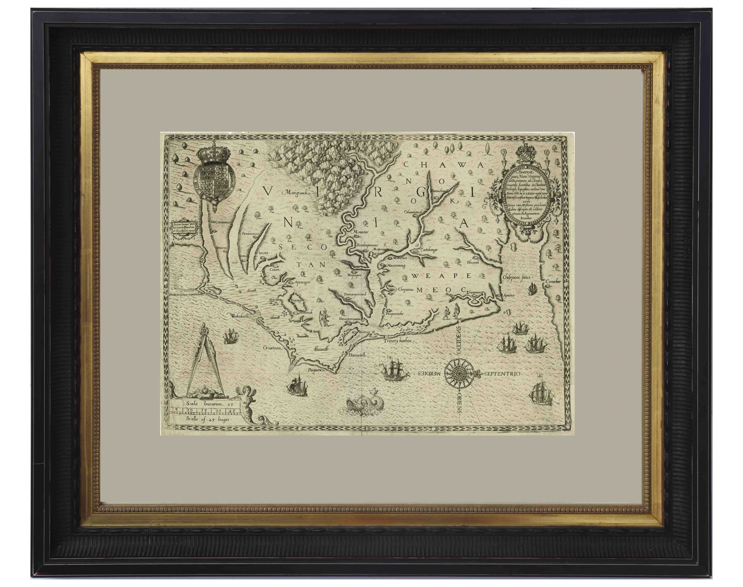
John White’s Map of Virginia From 1590 — The First Printed Map of Virginia and North Carolina
An important 16th century North American map known not only for its level of detail and accuracy, but also for its “firsts”: the first printed map of Virginia and North Carolina, the first to use Virginia in its title, the first to name the Chesapeake Bay, and also the first regional map showing the Roanoke Colony. Frankfurt: Theodor de Bry (engraver) for inclusion in his “Anglorum in Virginiam aduentus”, 1590.
Map is based on the work of cartographer, artist and explorer John White, one of the first settlers and Governor of the Roanoke Colony who, after sailing back to the Colony from England in 1587, had found all the colonists famously missing, their fate a mystery still unsolved. Philip Burden, who wrote the definitive reference book, “The Mapping of North America”, wrote of this map: “One of the most significant cartographical milestones in colonial North American history…the most accurate map drawn in the sixteenth century of any part of that continent.”
This full-sheet engraved map still retains its dark print, with the English Royal Arms at top left, and artistic touches throughout such as ships and sea monsters in the open ocean, and Native American canoeists in the inland waters. Map is the second state, with “C” laid over the “E” in Ehesepiooc. Map measures 16.675″ x 12.25″, nicely matted and framed to a size of 28″ x 23.5″. Expert repair to single vertical fold, and small area of repair to lower right corner, just touching the edge of the ship, where paper loss has been replaced. Overall in very good to near fine condition given age, displaying beautifully. Sold for $6,665.
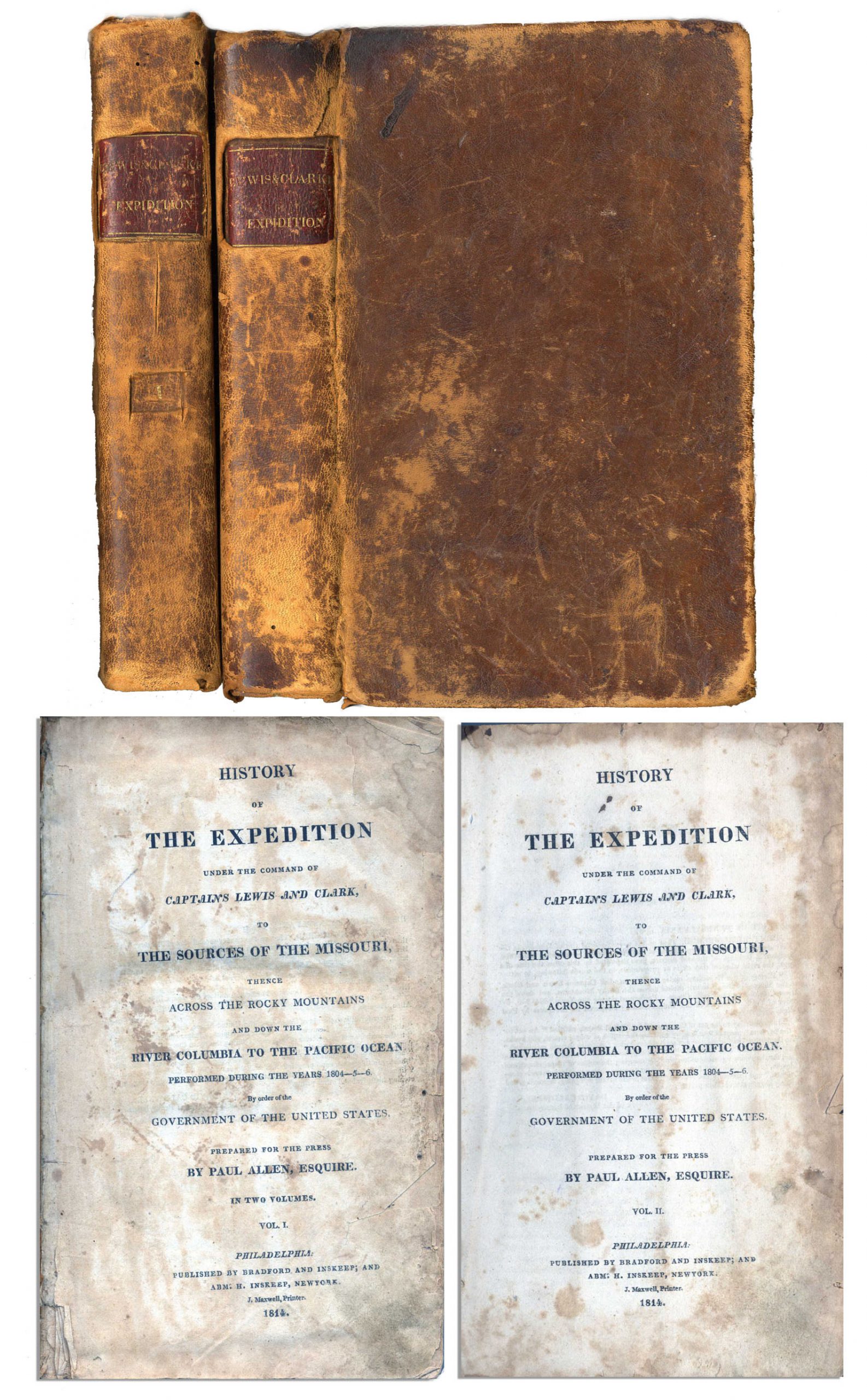
First edition, two-volume set of ”History of the Expedition under the Command of Captains Lewis and Clark to the source of the Missouri thence across the Rocky Mountains and down the river Columbia to the Pacific Ocean performed during the years 1804-05-06 by Meriwether Lewis and William Clark”. Published by Bradford and Inskeep: New York: 1814. Regarded as the definitive account of the first exhaustive, and most important Western exploration of America, which covered some eight thousand miles in slightly more than twenty-eight months. Lewis and Clark brought back the first reliable information about much of the area they traversed, made contact with the Native Americans as a prelude to the expansion of the fur trade, and advanced the geographical knowledge of the continent. This official account of the expedition is as much a landmark in Americana as the trip itself. Books, each measuring 5.5” x 8.75”, are bound in original marble-patterned leather boards and have five engraved, bound-in maps, missing the fold-out map found in some copies. Covers are worn and scuffed and the inside of covers have insect channels. Vol. I, 470pp., is missing the front free endpaper and has a chip out of the title page. Volume II runs 522pp. Light foxing and dampstaining throughout both volumes and some paper loss not affecting text. Overall in very good condition. An attractive set of America’s most important exploration narrative. Sold for $6,544.
Revolutionary War Map 1776
Revolutionary War map dated March 1776. “The Theatre of War in North America, With the Roads and a Table of the Distances…” Printed in London for R. Sayer and J. Bennett. Map depicts the area east of the Mississippi River from James Bay to Cape Canaveral, and locates provincial boundaries, towns, forts, roads, Indian villages, New England fishing waters, and the like. An inset is comprised of “Evan’s Polymetric Table of America,” which allows one to calculate the distance between most of the prominent towns. Text below the map reads, “A Compendious Account of the British Colonies in North America,” which devotes a paragraph of description to each of the North American colonies, including Florida, Canada, and the Province of Quebec. Issued separately by Sayer and Bennett, who also published “the American Military Pocket Atlas,” that year for the use of British officers. A notable map of the American Revolution, published the same year as the American Declaration of Independence. 20.75″ x 28.5″; 29.25″ x 37.5″ framed. Excellent condition. Sold for $6,000.

Scarce First Edition, First Printing Map of London Just After the Great Fire in 1666, by Wenceslaus Hollar
A very rare first printing of the post-Great Fire map of London by noted artist and engraver to the King, Wenceslaus Hollar. After the Great Fire swept across London in September 1666, destroying nearly 90% of the homes, Hollar almost immediately produced this map, titled “A MAP or GROUNDPLOT of the Citty of London”, noted for its accuracy and attention to detail. Printed in London by John Overton, 1666. Appointed by King Charles II to document the destruction, Hollar was able to quickly plot the map based on his previous but failed passion project – to produce the greatest map of London that ever existed. Hollar used those previous drawings as the basis for his post-Great Fire map, adding detail for areas that survived the fire, and foregoing details for the destroyed areas. The result was an immensely popular and well-received map that grounded Hollar’s reputation as engraver and cartographer. In this first printing – distinguished by the placement of the legend, inset map and scale of the city, Hollar documents the destruction of London, from Lincoln’s Inn Fields in the west to East Smith’s Field in the east, including the Great Tower of London, and from just south of the Thames River in the south to Bunhill Fields Burial Ground in the north. An inset to churches throughout the city “and other remarkable places” is present, as is a scale for the map. Finally, an inset map showing a larger portion of London is found at lower left, including Westminster which narrowly missed the fire’s path. Map is astonishingly complete and detailed given the speed that Hollar produced it, with printed signature appearing at bottom of inset map, “W. Hollar fecit [Latin, ‘he made’] 1666″. Map measures 14.5″ x 12”. Light toning and faint creasing, small quarter-inch closed tear at lower left margin, and spot of discoloration at mid-right margin. Mounting remnants on verso. Overall near fine condition given age. Sold for $4,383.

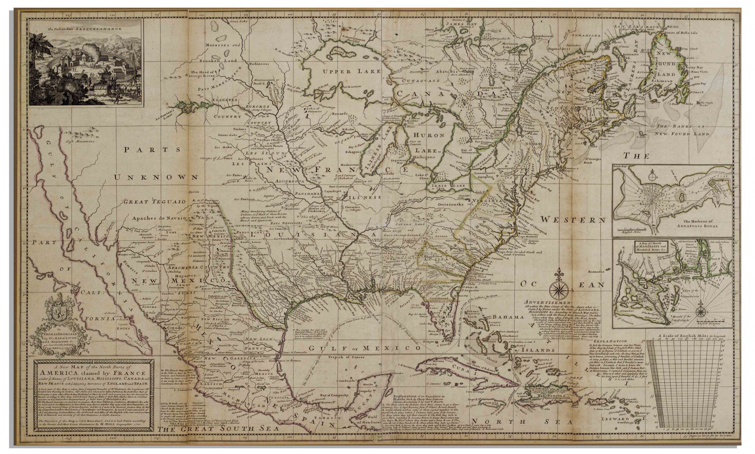
Americas Map Published in 1720 by London Cartographer Herman Moll — Measures 25″ x 40.75″
Large map of the Americas, published in 1720 by London cartographer Herman Moll entitled “A New Map of the North Parts of America claimed by France under ye names of Louisiana, Mississipi, Canada and New France with ye adjoyning territories of England and Spain”. Engraved map incorporates the latest surveying of the Americas, such as a French expedition into Texas in 1716. Map is hand-colored at boundaries, featuring a vignette at upper left of “The Indian Fort Sasquesahanok”, and with various “Explanations” of the map printed at bottom, including one of an Indian expedition into Florida, “6 days Rowing”. Insets of the Annapolis Harbor and the mouths of the Mississippi and Mobile Rivers are also included. Map is published in four vertical sections, laid down on archival paper and mounted on board. Map measures 25″ x 40.75″. Minor browning at section lines and a few spots of buckling. An attractive map in very good condition, giving historical insight into the jockeying for land among the major European powers in the early 18th century. Sold for $3,200.
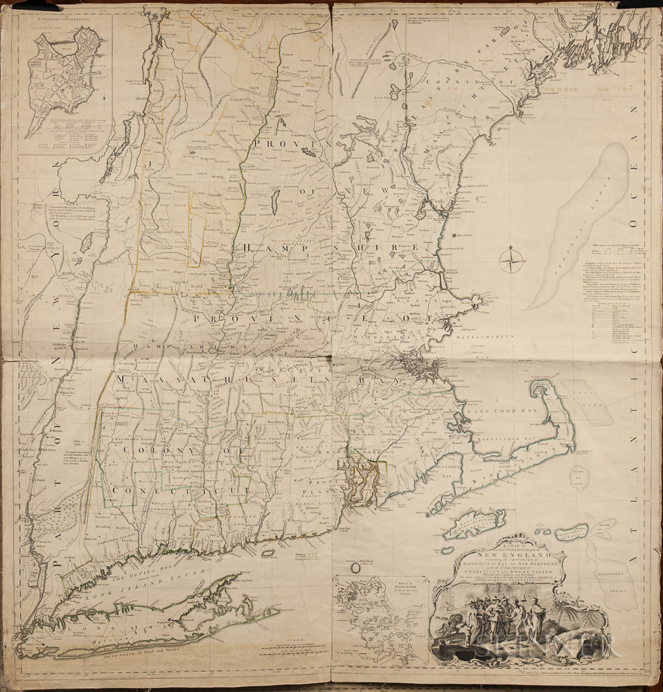
1774 Map of New England measuring over 40” square, the earliest large scale map of the New England colonies and used in the American Revolution. Drawn by Braddock Mead, and originally published in 1755, this copy was included in Thomas Jefferys’ ”American Atlas”, with hand-outlines. London: Printed and sold by R. Sayer and J. Bennett, 1776 (map dated 1774). Entitled in full, ”A Map of the Most Inhabited Part of New England Containing the Provinces of Massachusetts Bay and New Hampshire, with the Colonies of Connecticut and Rhode Island, Divided into Counties and Townships: The whole composed from Actual Surveys and its Situation adjusted by Astronomical Observations.” Measures 40” x 41.25”. Folded in fourths, as printed by copper-plate engraving on laid paper, mounted to linen. Light toning, chipping along margins and separation starting along folds. Overall in very good condition, a bright copy ideal for framing. Sold for $1,875.
John Speed Map of New England and New York 1676
The most famous 17th century map of New England, engraved by cartographer Francis Lamb with Anglican names for the first time reflecting the shift from Dutch to English rule, such as New York rather than New Amsterdam and “New Jarsey”. London: Basset and Chisswell, 1676, from the reissue of John Speed’s atlas, “The Theatre of the Empire of Great Britaine”, with new maps of the English colonies. Colorful double-page map entitled “A Map of New England and New York”, shows wildlife of the area in addition to topography and boundary lines. With English text on verso headlined, “The Description of New Neatherlands [sic] now called NEW-YORK” and “The Description of New England”. Engraved map measures 21″ x 17.125″, hinged at top to mat measuring 26.375″ x 21.375″. Slight offset along center fold, tape repair to verso, small separation at top center fold, and minute foxing. Overall very good plus condition. Sold for $1,800.

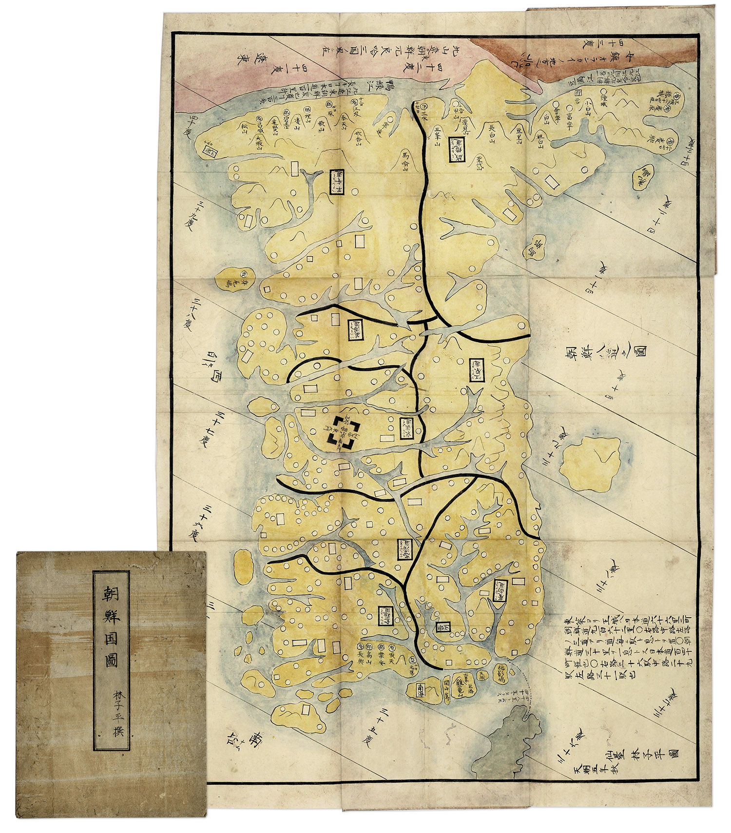
Hand-painted map of Korea by Hayashi Shihei, from Japan, circa 1785. Fold-out map shows the kingdoms outside Japan’s boundaries, but with the Kingdom of Joseon (Korea) being an important trading partner, the map was considered dangerous, and consequently banned by the Shogun in 1792. Has original cover boards and title slip. Measures 20” x 29” when folded out, and 7” x 9.5” when closed. Lightly toned and soiled, overall very good condition. Sold for $1,563.
Consign your item at Nate D. Sanders Auctions. Send a description of your item and images of your item to us at [email protected].
FREE APPRAISAL. To buy, auction, sell or consign your Henry Pelham Plan of Boston in New England 1777 that is for sale, please email your description and photos to [email protected] of Nate D. Sanders Auctions (http://www.NateDSanders.com).
Henry Pelham Plan of Boston in New England 1777