Sell or Auction Your Henry Chapman Ford Missions of California 1883 for up to Over $35,000 or More at Nate D. Sanders Auctions
FREE APPRAISAL. To buy, auction, sell or consign your Henry Chapman Ford Missions of California 1883 that is for sale, please email your description and photos to [email protected] of Nate D. Sanders Auctions (http://www.NateDSanders.com).
Free Appraisal, Auction or Sell Your Henry Chapman Ford Missions of California 1883
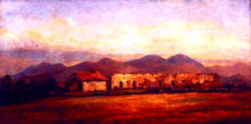
Henry Chapman Ford was a 19th century American illustrator who studied in Paris and Florence in the 1850s. He served in the Civil War as a soldier who created illustrations of interest to the military. In his later years he settled in California and traveled to all 21 California missions and created a historically significant portfolio of paintings and etchings. In 1883 he published his work in Etchings of the Franciscan Missions of California.
Below is a recent realized price for a copy of Henry Chapman Ford Missions of California 1883. We at Nate D. Sanders Auctions can obtain up to this amount or more for you:
Henry Chapman Ford Missions of California 1883. Sold for Over $35,000.
The following are some related items we have sold:
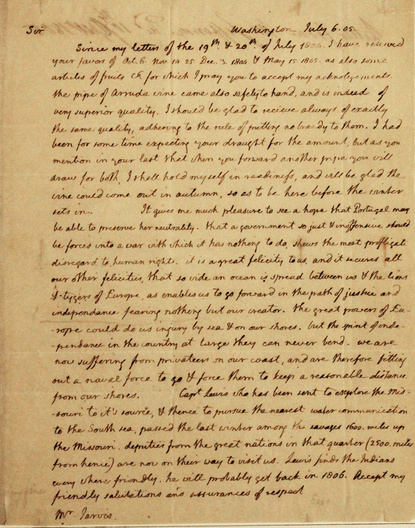
Thomas Jefferson Handwritten Report as President Regarding the Lewis & Clark Expedition
Exceptional, museum-worthy report, handwritten by Thomas Jefferson as President, regarding the Lewis and Clark Expedition. Letter is addressed to William Jarvis of the U.S. consul in Lisbon, Portugal, dated 6 July 1805, describing the historic expedition that Jefferson authorized during his Presidency. In its entirety: “Sir / Since my letters of the 19th & 20th of July 1804 I have received your favors of Oct. 6 Nov. 14-25 Dec. 3 1806 & May 15 1805. As also some articles of fruits & for which I may you accept my acknowledgments. The pipe of Arruda vine came also safely to hand, and is indeed of very superior quality. I should be glad to receive always of exactly the same quality, adhering to the rule of putting no brandy to them. I had been for some time expecting your draught [draft] for the amount; but as you mention in your last that when you forward another pipe you will draw for both, I shall hold myself in readiness, and will be glad the vine would come out in autumn, so as to be here before the winter sets in. It gives me much pleasure to see a hope that Portugal may be able to preserve her neutrality. That a government so just & inoffensive should be forced into a war with which it has nothing to do shows the most profligate disregard to human rights. It is a great felicity to us and it secures all our other felicities, that so wide an ocean is spread between us & the lions & tygers of Europe, as enables us to go forward in the path of justice and independence fearing nothing but our creator.
The great powers of Europe could do us injury by sea & on our shores. But the spirit of independence in the country at large they can never bend. We are now suffering from privateers on our coast, and are therefore fitting out a naval force to go & force them to keep a reasonable distance from our shores. Capt. Lewis who has been sent to explore the Missouri to its source & thence to pursue the nearest water communication to the South sea, passed the last winter among the savages 1600 miles up the Missouri. Deputies from the great nations in that quarter (2500 miles from hence) are now on their way to visit us. Lewis finds the Indians every where friendly. He will probably set back in 1806. Receipt my friendly salutations and assurances of respect.” Document measures 8″ x 10″ on two pages, with integral fly-leaf addressed to Jarvis in the hand of Jefferson’s secretary. Toning and folds throughout, with minor tape residue at top and a tiny chip at lower right corner. Near fine condition with bold, legible handwriting. An important piece of handwritten history by the President who commissioned America’s greatest exploration adventure. ADDITIONAL INFORMATION: A near exact copy of this letter resides in the Library of Congress’ Thomas Jefferson Papers. One of the two letters was produced by Jefferson’s polygraph machine (used from 1804 until his death), which provided an immediate copy of his handwritten letters. Though impossible to determine which copy was produced by the pen that Jefferson held, Jefferson typically kept the machine-produced letter as a copy for himself. Since this letter was mailed to William Jarvis (unlike the letter in the LOC), it’s probable that this letter was the one handwritten by Jefferson. It sold for $226,871.
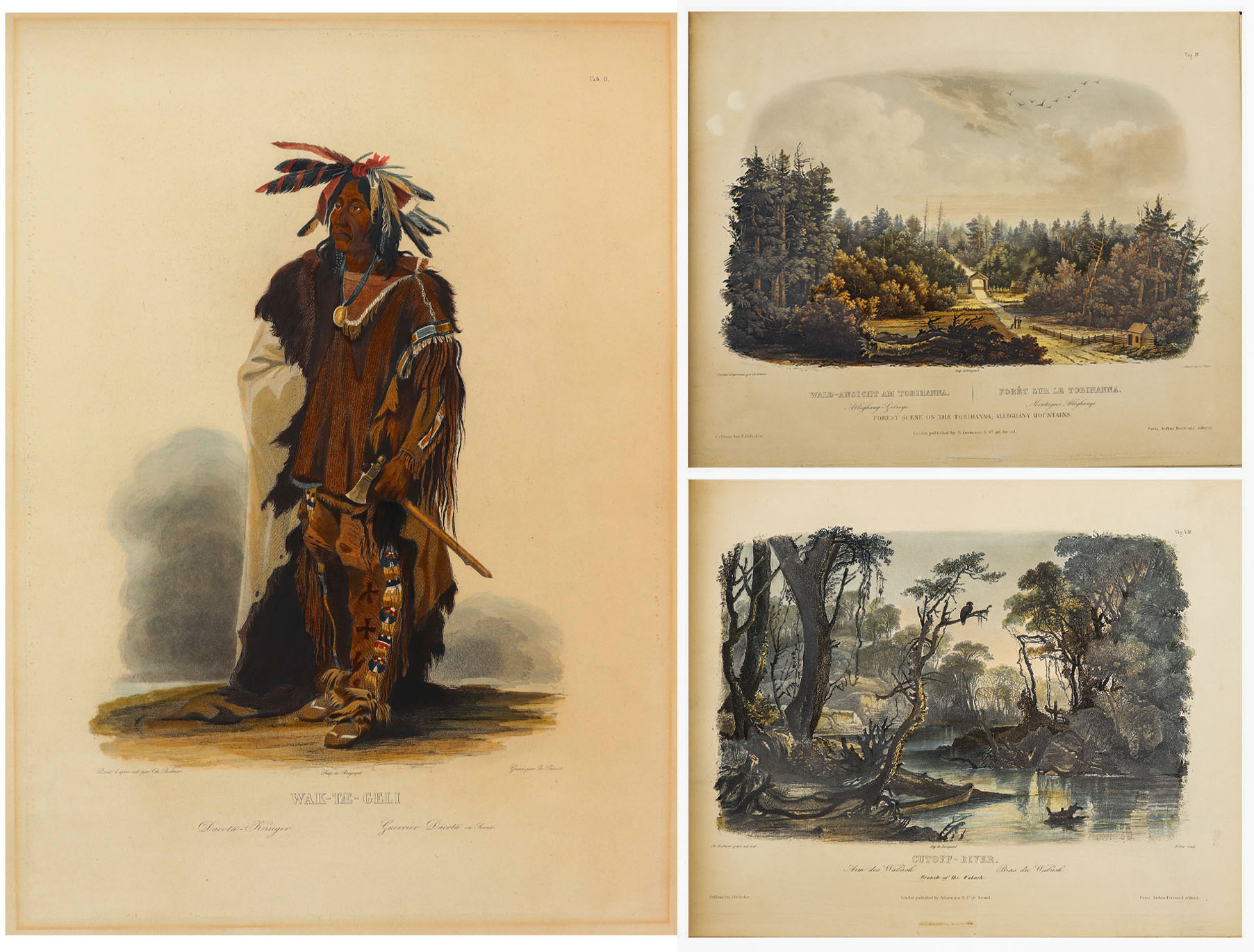
81 Beautiful Hand-Colored Aquatints by Karl Bodmer Depicting the American Frontier in the 1830s — Contained in the Illustrated Travelogue “Prince of Wied’s Travels in the Interior of North America”
Stunningly beautiful collection of 81 hand-colored aquatints by the Swiss artist Karl Bodmer, a complete collection from the illustrated travelogue, “Prince of Wied’s Travels in the Interior of North America”. Bodmer, who journeyed with the German Prince Maximilian of Wied-Neuwied from 1833-34 along the Missouri River, produced what is considered the best depictions of the indigenous peoples and landscapes during the frontier era, an America then still unspoiled by western migration. Of the Native American tribes of the Great Plains that they encountered, Bodmer’s depictions of the Blackfeet and Mandan tribes are especially important as the populations of these tribes were greatly affected by the smallpox epidemic of 1837, thus making Bodmer’s work the last visual testament to their culture.
Prince Max, as he was called, chose Bodmer to accompany him on the expedition along the Missouri River to visually depict the scenes that the Prince would write about. The result is this collection: three volumes of text by the Prince and two volumes of aquatints by Bodmer, in the first Paris edition published by Chez Arthus Bertrand, 1840-43 (“Voyage dans l’interieur de l’Amerique du Nord”). Text volumes in French also include 37 wood-engraved illustrations, only lacking the map in completeness. The two complete volumes of illustrations include the large folio volume with 48 oversized hand-colored aquatints measuring approximately 24.5″ x 18″, and the quarto volume with 33 hand-colored aquatints measuring approximately 12.5″ x 10.25″. The complete set of 81 aquatints is magnificent in their display, a time capsule with their hand-coloring evoking the sense of awe and discovery of the expedition. All volumes are bound in half black morocco and blue paper-covered boards with gilt accenting, and with black morocco labels to illustrated volumes. Minor handling wear to volumes, with a few small repaired tears to plates, some plates supplied with variance to margins, minute toning and foxing, a few plates beginning to separate from binding. Overall a very good plus set with excellent display quality. Sold for $175,000.


Scarce collection of 63 photographs from Carleton Watkins’ groundbreaking publication, ”Yosemite Valley: Photographic Views of the Falls and Valley of Yosemite in Mariposa County, California”. San Francisco, 1863. One of the most complete collections, lot comprises a total of 63 photographs, with two of the title page and map, and 61 of the Yosemite Valley, each measuring 11.625” x 7.5”. Scarce as such.
Lured out to California for the Gold Rush, Watkins soon turned his pursuits to photography, a calling for which he was naturally gifted. In 1861, he traveled to Yosemite outfitted with both mammoth-plate and stereoscopic cameras to make the first photographic narrative of the majestic valley, with these photographs the result. They were so impactful, after having been shared amongst Congressmen and Abraham Lincoln, that the Yosemite Grant Act was passed in 1864, a precursor to the creation of the U.S. National Park System in 1872.
Interestingly, no complete accounting of Watkins’ Yosemite photos from 1863 is documented, but next to a collection of 65 photographs, this grouping is the most complete at 63 photographs. Only a handful of other collections even claim more than 50 photographs. The views are exquisite, capturing the rock formations, foliage and natural water sources of the Valley as they appeared in 1861, yet unspoiled by overcrowding. Watkins’ ability to capture the depth of the images – with distant mountains hovering over meadows and streams, is particularly beautiful, aided by the use of his two camera systems.
Photographs retain superb contrast and tonality, all disbound in a period brown morocco gilt slipcase, tooled in gilt on the cover, ”Watkins’ Yosemite Gallery.” Overall in very good to near fine condition. Sold for $112,500.

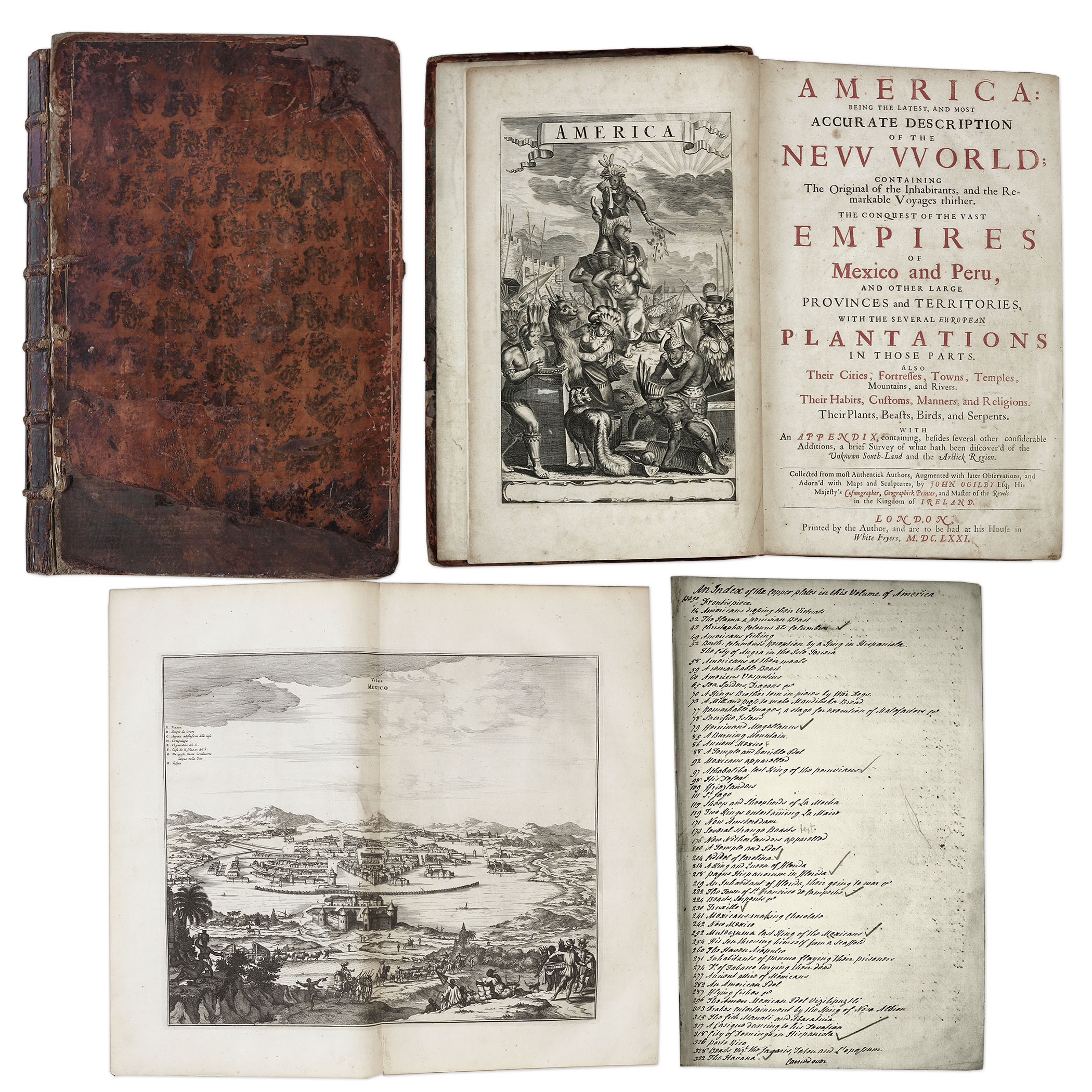
One of the most important books on the history of America (cited by Borba de Moraes, Howes, Sabin and Wing), the 1671 first edition of ”America: Being the Latest and Most Accurate Description of the New World”. Privately printed in London by the author, Arnoldus Montanus, and edited by John Ogilby. In ”America” Montanus goes into great detail of the new continents, with dozens of engravings of Native Americans, species of animals and reptiles, and the landscapes and settlements in the new world, accompanied by text. The book covers speculation regarding the earliest voyages to America, along with later recorded voyages and the settlements of New Netherlands/New York, New England, Hudson’s Bay, Labrador, Canada, Nova Scotia, Maryland, Virginia, (including Captain Smith’s capture and rescue by Pocahontas), Carolinas, Florida and California, plus accounts of Mexico and nearby islands, even including Australia and New Zealand. 674pp. book contains 75 original engravings (64 copper plates within the text and 9 plates throughout), lacking the maps and 28 engravings, which is typical as this edition is almost never found with all plates intact. All text is complete except for missing pages 445-446. Large format book measures 10” x 15”. Bound in original full leather boards, with some loss of leather to covers, cracking along spine and front board detached. Interior text is near fine and very readable. An important and fascinating addition to early knowledge of the American continent. Sold for $9,375.
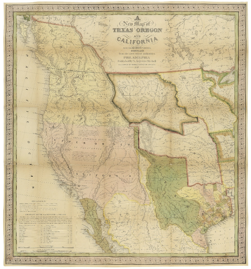
Map of Texas, Oregon and California From 1846 — The Definitive Map Used by Western Settlers During the Gold Rush
“A New Map of Texas Oregon and California with the Regions Adjoining. Compiled from the most recent authorities.” By cartographer Samuel Augustus Mitchell, published in 1846 as a pocket map, and considered the definitive map for settlers in the nation’s westward expansion during the Gold Rush. Philadelphia: Published by S. Augustus Mitchell, 1846. With contemporary hand-coloring, folding map by engraver H.N. Burroughs was Mitchell’s most important map, considered the defacto standard and thereby affecting subsequent maps of the area. It was the first to include recent explorations in the Great Basin, with boundary lines of Rio Grande to the south, and Oregon to the north at 54 degrees 40 minutes, above which are “British Possessions”. An inset to lower left entitled “Emigrant Route from Missouri to Oregon”, provides the distance between western cities and landmarks, undoubtedly aiding weary travelers. With decorative scrollwork along the margins, map measures 21″ x 22.5″ unfolded, nicely matted and framed to a size of 34.5″ x 41.5″. Some expert repair at fold separations and mild fading, overall in very good condition. Sold for $4,800.
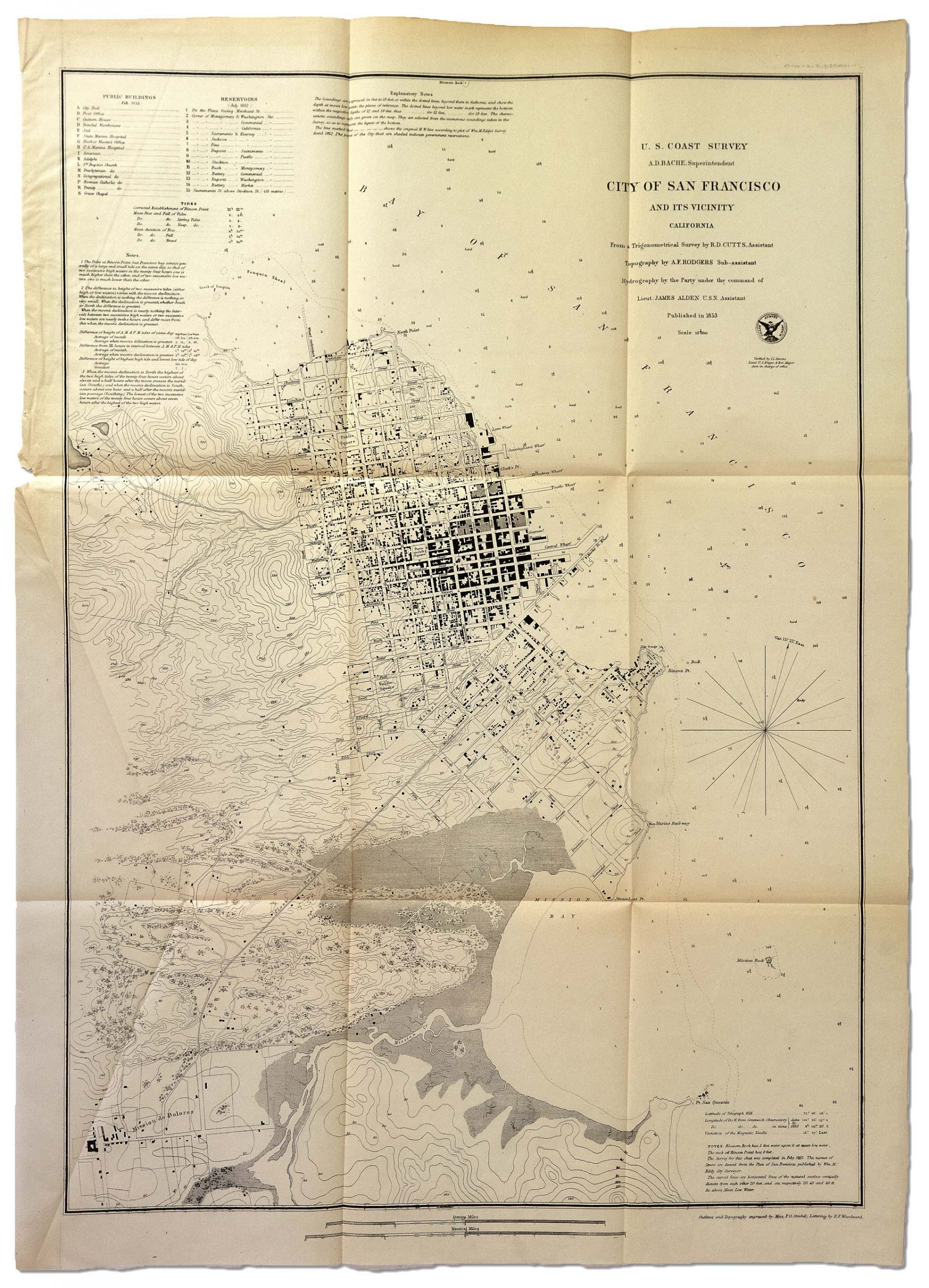
Wonderful vintage map of the City of San Francisco, published 1853 at the height of the California Gold Rush. Washington: U.S. Coast Survey, 1853. Engraved map by A.D. Bache shows the city extending only about 11 blocks west from the water, with public buildings noted, such as City Hall, the Post Office and the Jail. Scale is 1:10,000, with details of Mission Bay and the San Francisco Bay also included. Sheet measures 20” x 28”. Trimmed top edge, folds, and light creasing. Overall in very good condition. Sold for $2,954.
James W. Marshall’s Signature — The Man Who Kicked Off The California Gold Rush in 1848 — Scarce
James W. Marshall signs a slip: “Ja’s. W. Marshall”. Beneath his signature is printed: “The Discoverer of Gold in California”. Marshall earned this distinction in 1848 when he found gold in the California River during his employ at the Old Sutter Mill, an etching of which is printed to the upper left. Measures 5.25″ x 2.75″. Toning and light staining with creasing to lower left, else near fine. Sold for $2,197.

FREE APPRAISAL. To buy, auction, sell or consign your Henry Chapman Ford Missions of California 1883 that is for sale, please email your description and photos to [email protected] of Nate D. Sanders Auctions (http://www.NateDSanders.com).
We offer the following services for your Henry Chapman Ford Missions of California 1883:
- Appraise Henry Chapman Ford Missions of California 1883.
- Auction Henry Chapman Ford Missions of California 1883.
- Consign Henry Chapman Ford Missions of California 1883.
- Estimate Henry Chapman Ford Missions of California 1883.
- Sell Henry Chapman Ford Missions of California 1883.