Sell or Auction Your Cook Voyage Towards South Pole 1772-5 & 1777 for up to Over $10,000 or More at Nate D. Sanders Auctions
FREE APPRAISAL. To buy, auction, sell or consign your Cook Voyage towards South Pole 1772-5 & 1777 that is for sale, please email your description and photos to [email protected] of Nate D. Sanders Auctions (http://www.NateDSanders.com).
Free Appraisal, Auction or Sell Your Cook Voyage Towards South Pole 1772-5 & 1777
James Cook FRS (7 November 1728 – 14 February 1779) was a British explorer, navigator, cartographer, and captain in the British Royal Navy, famous for his three voyages between 1768 and 1779 in the Pacific Ocean and to New Zealand and Australia in particular. He made detailed maps of Newfoundland prior to making three voyages to the Pacific, during which he achieved the first recorded European contact with the eastern coastline of Australia and the Hawaiian Islands, and the first recorded circumnavigation of New Zealand.
Below is a recent realized price for a Cook Voyage towards South Pole 1772-5 & 1777 item. We at Nate D. Sanders Auctions can obtain up to this amount or more for you:
Cook Voyage Towards South Pole 1772-5 & 1777. Sold for over $10,000.
Here are some recent items that our auction house, Nate D. Sanders (http://www.NateDSanders.com) has sold:
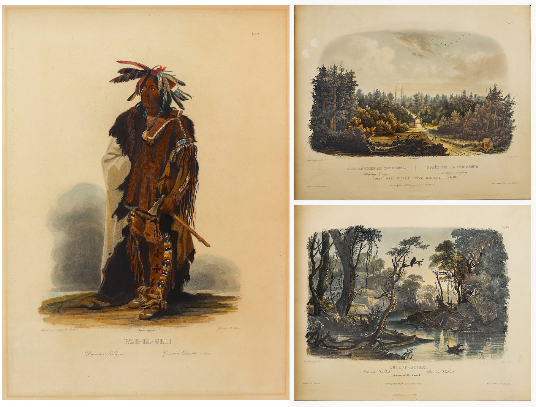
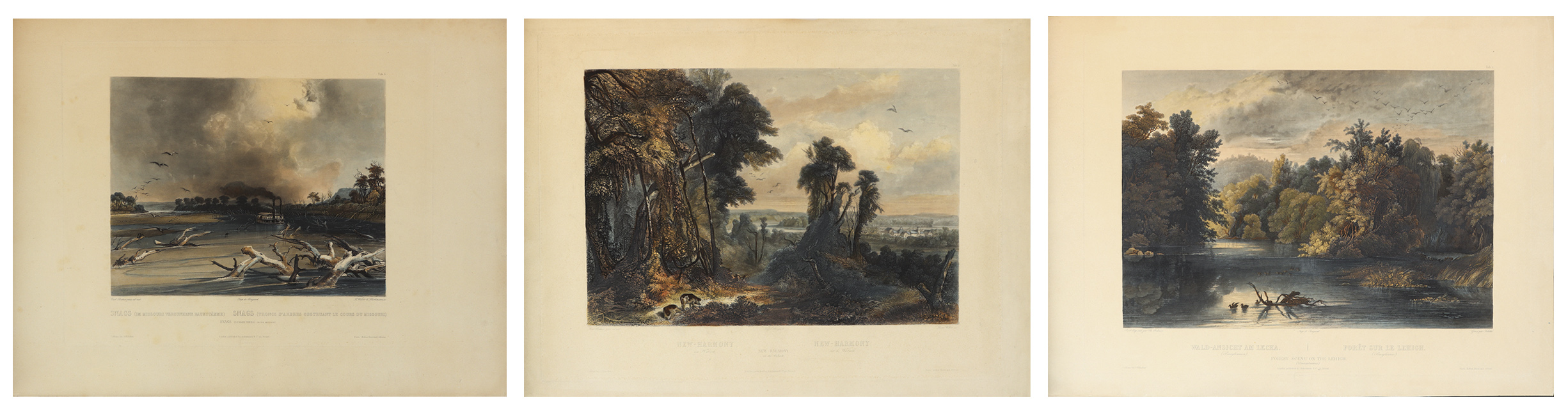
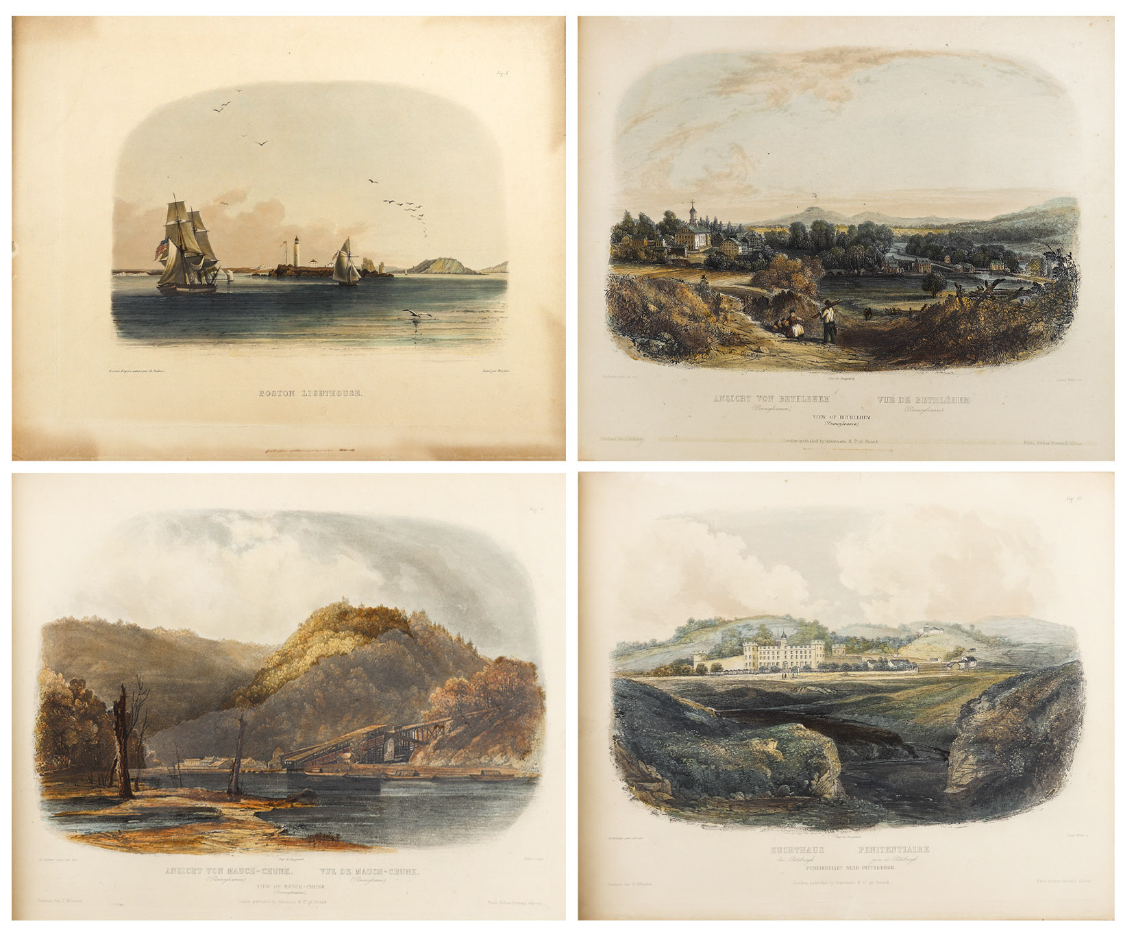
Karl Bodmer Prince of Wied’s Travels in the Interior
Stunningly beautiful collection of 81 hand-colored aquatints by the Swiss artist Karl Bodmer, a complete collection from the illustrated travelogue, “Prince of Wied’s Travels in the Interior of North America”. Bodmer, who journeyed with the German Prince Maximilian of Wied-Neuwied from 1833-34 along the Missouri River, produced what is considered the best depictions of the indigenous peoples and landscapes during the frontier era, an America then still unspoiled by western migration. Of the Native American tribes of the Great Plains that they encountered, Bodmer’s depictions of the Blackfeet and Mandan tribes are especially important as the populations of these tribes were greatly affected by the smallpox epidemic of 1837, thus making Bodmer’s work the last visual testament to their culture.
Prince Max, as he was called, chose Bodmer to accompany him on the expedition along the Missouri River to visually depict the scenes that the Prince would write about. The result is this collection: three volumes of text by the Prince and two volumes of aquatints by Bodmer, in the first Paris edition published by Chez Arthus Bertrand, 1840-43 (“Voyage dans l’interieur de l’Amerique du Nord”). Text volumes in French also include 37 wood-engraved illustrations, only lacking the map in completeness. The two complete volumes of illustrations include the large folio volume with 48 oversized hand-colored aquatints measuring approximately 24.5″ x 18″, and the quarto volume with 33 hand-colored aquatints measuring approximately 12.5″ x 10.25″. The complete set of 81 aquatints is magnificent in their display, a time capsule with their hand-coloring evoking the sense of awe and discovery of the expedition. All volumes are bound in half black morocco and blue paper-covered boards with gilt accenting, and with black morocco labels to illustrated volumes. Minor handling wear to volumes, with a few small repaired tears to plates, some plates supplied with variance to margins, minute toning and foxing, a few plates beginning to separate from binding. Overall a very good plus set with excellent display quality. Sold for $175,000.
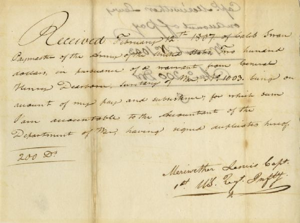
Very scarce Meriwether Lewis document signed ”Meriwether Lewis Capt. / 1st U’S. Regt. Infty.” Single octavo page, dated 12 February 1807 reads in full: ”Received February 12th 1807 of Caleb Swan Paymaster of the Army of the United States, Two hundred dollars, in pursuance of a warrant from General Henry Dearborn Secretary of War, No. 1003, being on account of my pay and subsistence, for which sum I am accountable to the Accountant of the Department of War, having signed duplicates hereof. 200 Drs.” In January 1803, President Thomas Jefferson sought to learn more about the far western territory, and appropriated the money from Congress for the proposed journey, to be led by the experienced explorer Meriwether Lewis. In his memoirs, Jefferson wrote of Lewis:
”Of courage undaunted; possessing a firmness and perseverance of purpose which nothing but impossibilities could divert from its direction; careful as a father of those committed to his charge, yet steady in the maintenance of order and discipline; intimate with the Indian characters, customs, and principles; habituated to the hunting life; guarded by exact observations of the vegetables and animals of his own country against losing time in the description of objects already possessed; honest, disinterested, liberal, of sound understanding, and a fidelity to truth so scrupulous that whatever he should report would be as certain as seen by ourselves…” (”History of the Expedition,” 1814). In the months immediately preceding the expedition, Lewis sought training in the use of astronomical instruments and in the art of map-making. He also chose a companion officer, William Clark of Louisville. While the expedition did not achieve the primary objective of finding the elusive Northwest Passage, it contributed significantly to the understanding of the geography of the Northwest and produced approximately 140 maps, the first accurate maps of the area. In addition, it documented 100 newly discovered species of animals, approximately 170 plants, and it also established friendly relations with three dozen Indian tribes. The knowledge they obtained sparked American interest in the west, and strengthened the nation’s claim to the area. Meriwether Lewis returned to Washington, D.C. from his three year journey in late December of 1806. After returning from the expedition, Lewis received a reward of 1,600 acres of land. In addition, Thomas Jefferson appointed him Governor of the Louisiana Territory. However, Lewis was not confirmed by the Senate until March 1807 and he remained a Captain in the interim. Base pay for Captains at this period was $40 per month so the present receipt would represent five months’ salary. A supremely rare document directly linking Meriwether Lewis to the Lewis & Clark Expedition. Items of Lewis & Clark related to the famed expedition are of the utmost rarity. Docketed on verso. Toning to folds and showthrough, otherwise near fine condition. Sold for $30,768.
Beautiful and scarce Pilgrim document from 17th century colonial America. Dated 1670, document confirms the sale of 50 acres of land in Marshfield, Plymouth County, Massachusetts by John Rogers to William Macomber. Document is signed by a veritable who’s-who of Pilgrim notables, including Rogers, Nathaniel Morton, Constant Southworth and James Toale (Towle). In addition to writing the first historical text published in the United States (about the settlement of the Plymouth Colony) Nathaniel Morton was the first to publish a list of signers of the Mayflower Compact and also wrote his account of the first Thanksgiving. He served for most of his life as Secretary of Plymouth Colony, where his careful record-keeping enabled him to compile New England’s Memorial, considered the first comprehensive history of the colony, published at Cambridge in 1669, and widely considered the first book of history published in the United States. In fact, ”The Wall Street Journal” has published an excerpt from Morton’s history of Plymouth Colony as an op-ed the Wednesday before Thanksgiving Day since 1961. Constant Southworth came to Plymouth in 1628 as a teenager, and held several prominent positions during his life, including Treasurer of the Colony. John Rogers was born in 1642 in Plymouth County, the son of a Mayflower passenger. Document measures approximately 15.5” x 12” with some paper loss to lower right. Some expected foxing and toning, small amount of paper loss and archival tape repair to verso. In very good condition considering age, with still bold writing. Sold for $10,000.

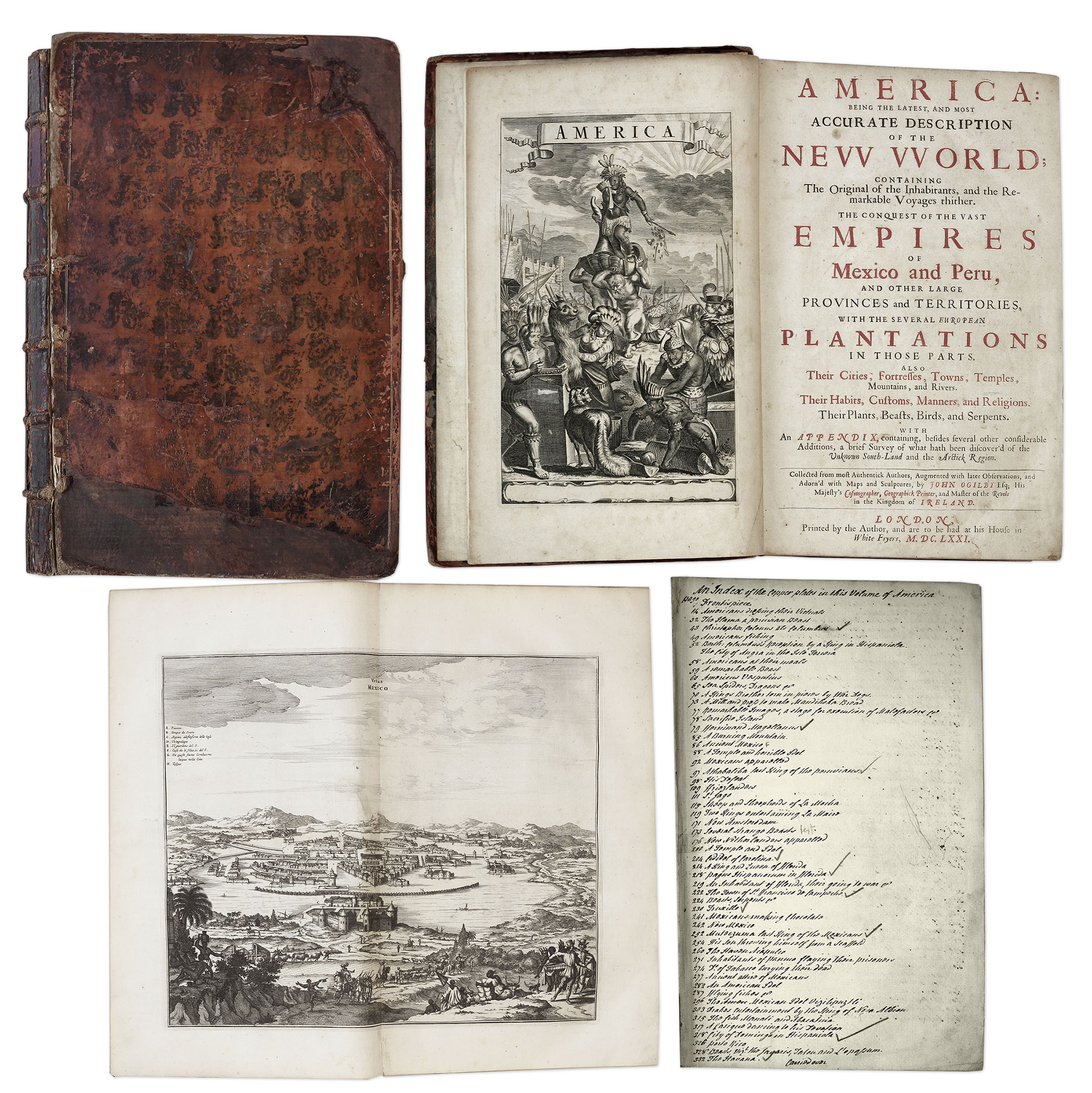
One of the most important books on the history of America (cited by Borba de Moraes, Howes, Sabin and Wing), the 1671 first edition of ”America: Being the Latest and Most Accurate Description of the New World”. Privately printed in London by the author, Arnoldus Montanus, and edited by John Ogilby. In ”America” Montanus goes into great detail of the new continents, with dozens of engravings of Native Americans, species of animals and reptiles, and the landscapes and settlements in the new world, accompanied by text. The book covers speculation regarding the earliest voyages to America, along with later recorded voyages and the settlements of New Netherlands/New York, New England, Hudson’s Bay, Labrador, Canada, Nova Scotia, Maryland, Virginia, (including Captain Smith’s capture and rescue by Pocahontas), Carolinas, Florida and California, plus accounts of Mexico and nearby islands, even including Australia and New Zealand. 674pp. book contains 75 original engravings (64 copper plates within the text and 9 plates throughout), lacking the maps and 28 engravings, which is typical as this edition is almost never found with all plates intact. All text is complete except for missing pages 445-446. Large format book measures 10” x 15”. Bound in original full leather boards, with some loss of leather to covers, cracking along spine and front board detached. Interior text is near fine and very readable. An important and fascinating addition to early knowledge of the American continent. Sold for $9,375.
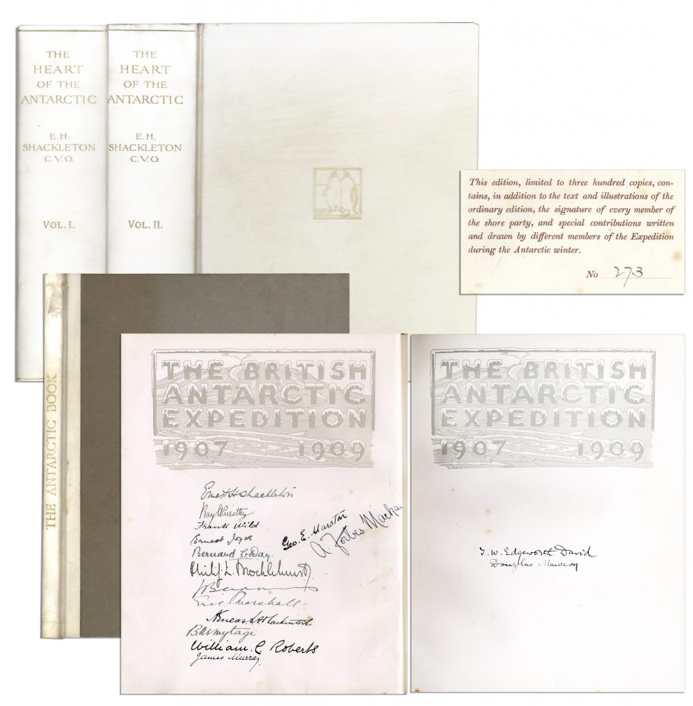
Ernest Shackleton & Crew Signed “The Heart of the Antarctic. Being the Story of the British Antarctic Expedition 1907-1909” Limited to Just 300 Copies, This Being All Three Volumes — Scarce
Ernest Shackleton’s signed copy of “The Heart of the Antarctic. Being the Story of the British Antarctic Expedition 1907-1909, 3 volumes (including “The Antarctic Book Winter Quarters 1907-09”), limited to 300 copies (here #273), also with signatures of the entire Shore party. Photogravure frontispiece, numerous plates (including 6 etched plates by George Marston, 16 tipped-in color after George Marston, others mostly photographic), one folding panorama and three folding lithographed maps in pocket at the end of volume three, illustrations and diagrams in the text. In publisher’s vellum, blocked in gilt with design of two penguins and top edges gilt. Occasional light spotting and small tear on cover of volume two. Overall in very good to near fine condition, signed by the Nimrod Shore Party crew. Sold for $12,718.
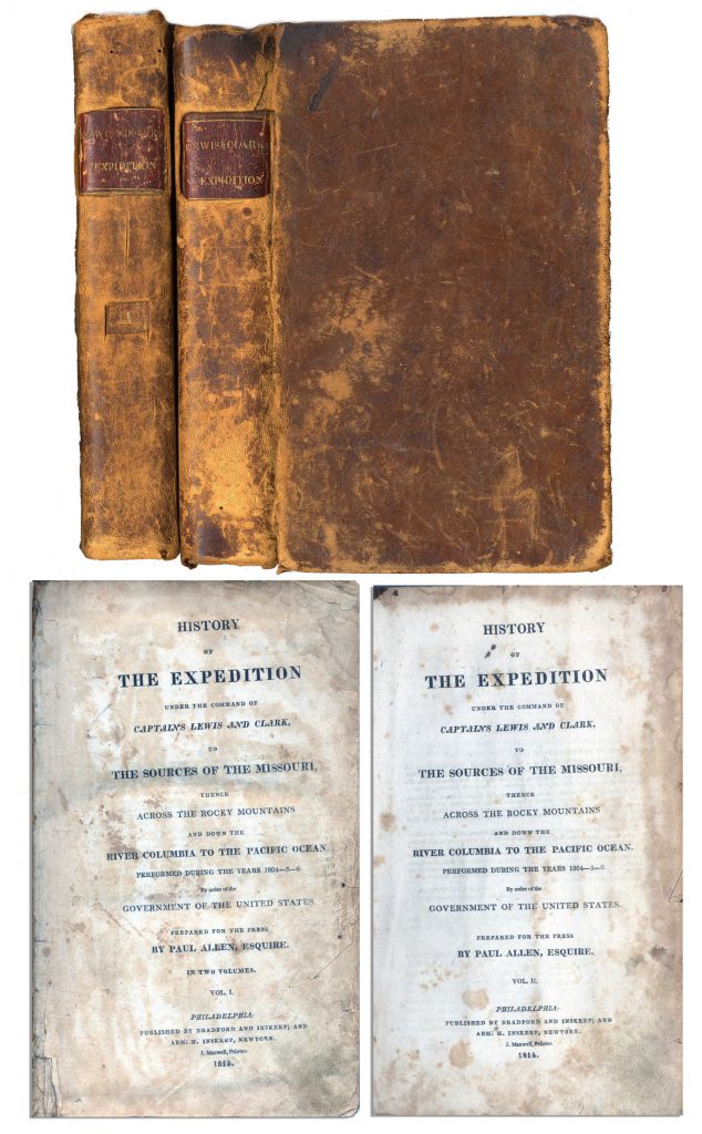
First edition, two-volume set of ”History of the Expedition under the Command of Captains Lewis and Clark to the source of the Missouri thence across the Rocky Mountains and down the river Columbia to the Pacific Ocean performed during the years 1804-05-06 by Meriwether Lewis and William Clark”. Published by Bradford and Inskeep: New York: 1814. Regarded as the definitive account of the first exhaustive, and most important Western exploration of America, which covered some eight thousand miles in slightly more than twenty-eight months. Lewis and Clark brought back the first reliable information about much of the area they traversed, made contact with the Native Americans as a prelude to the expansion of the fur trade, and advanced the geographical knowledge of the continent. This official account of the expedition is as much a landmark in Americana as the trip itself. Books, each measuring 5.5” x 8.75”, are bound in original marble-patterned leather boards and have five engraved, bound-in maps, missing the fold-out map found in some copies. Covers are worn and scuffed and the inside of covers have insect channels. Vol. I, 470pp., is missing the front free endpaper and has a chip out of the title page. Volume II runs 522pp. Light foxing and dampstaining throughout both volumes and some paper loss not affecting text. Overall in very good condition. An attractive set of America’s most important exploration narrative. Sold for $6,544.
FREE APPRAISAL. To buy, auction, sell or consign your Cook Voyage towards South Pole 1772-5 & 1777 that is for sale, please email your description and photos to [email protected] of Nate D. Sanders Auctions (http://www.NateDSanders.com).