Sell or Auction Your John Winthrop Document Signed for up to Nearly $10,000 or More at Nate D. Sanders Auctions
FREE APPRAISAL. To buy, auction, sell or consign your John Winthrop document signed that is for sale, please email your description and photos to [email protected] of Nate D. Sanders Auctions (http://www.NateDSanders.com).
Free Appraisal, Auction or Sell Your John Winthrop Document Signed
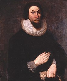
Below is a recent realized price for a document signed from Puritan and one of the founders of the Massachusetts Bay Colony, John Winthrop. We at Nate D. Sanders Auctions can obtain up to this amount or more for you:
John Winthrop Document Signed. Sold for Nearly $10,000.
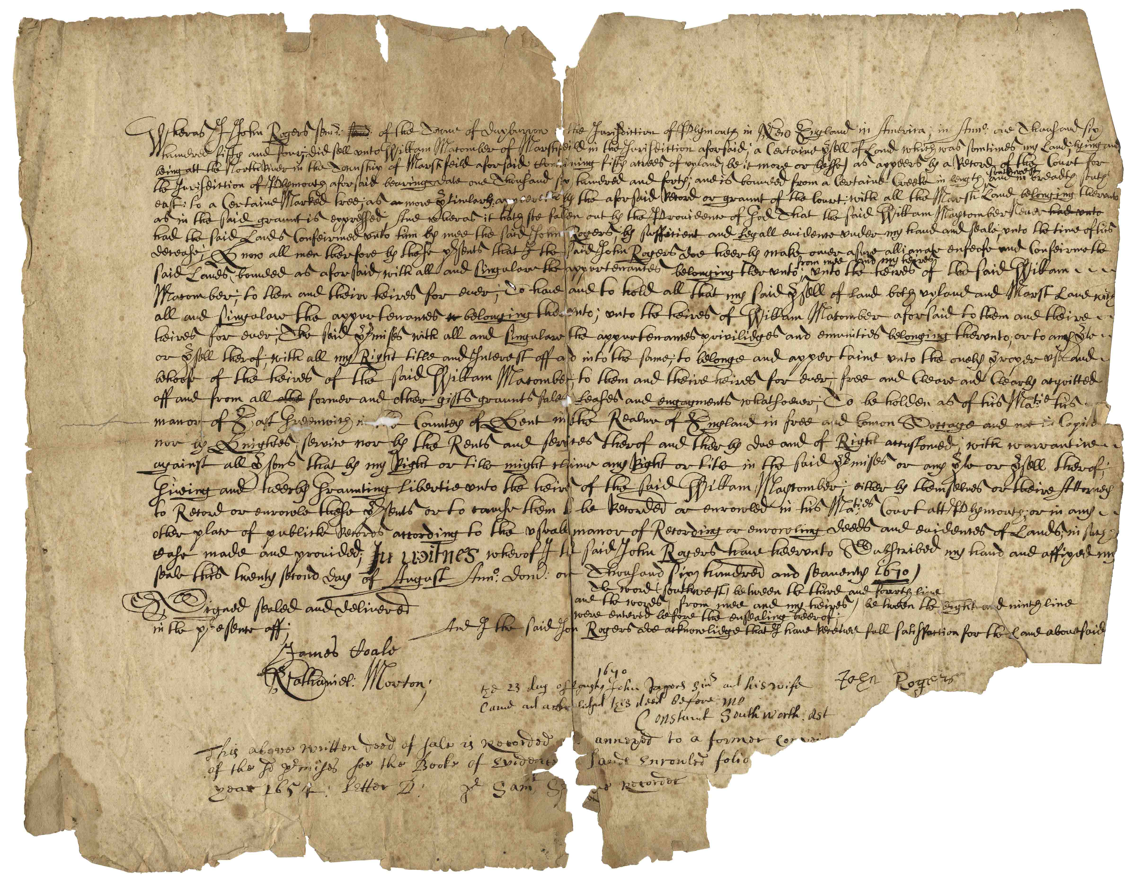
Beautiful and scarce Pilgrim document from 17th century colonial America. Dated 1670, document confirms the sale of 50 acres of land in Marshfield, Plymouth County, Massachusetts by John Rogers to William Macomber. Document is signed by a veritable who’s-who of Pilgrim notables, including Rogers, Nathaniel Morton, Constant Southworth and James Toale (Towle). In addition to writing the first historical text published in the United States (about the settlement of the Plymouth Colony) Nathaniel Morton was the first to publish a list of signers of the Mayflower Compact and also wrote his account of the first Thanksgiving. He served for most of his life as Secretary of Plymouth Colony, where his careful record-keeping enabled him to compile New England’s Memorial, considered the first comprehensive history of the colony, published at Cambridge in 1669, and widely considered the first book of history published in the United States. In fact, ”The Wall Street Journal” has published an excerpt from Morton’s history of Plymouth Colony as an op-ed the Wednesday before Thanksgiving Day since 1961. Constant Southworth came to Plymouth in 1628 as a teenager, and held several prominent positions during his life, including Treasurer of the Colony. John Rogers was born in 1642 in Plymouth County, the son of a Mayflower passenger. Document measures approximately 15.5” x 12” with some paper loss to lower right. Some expected foxing and toning, small amount of paper loss and archival tape repair to verso. In very good condition considering age, with still bold writing. Sold for $10,000.
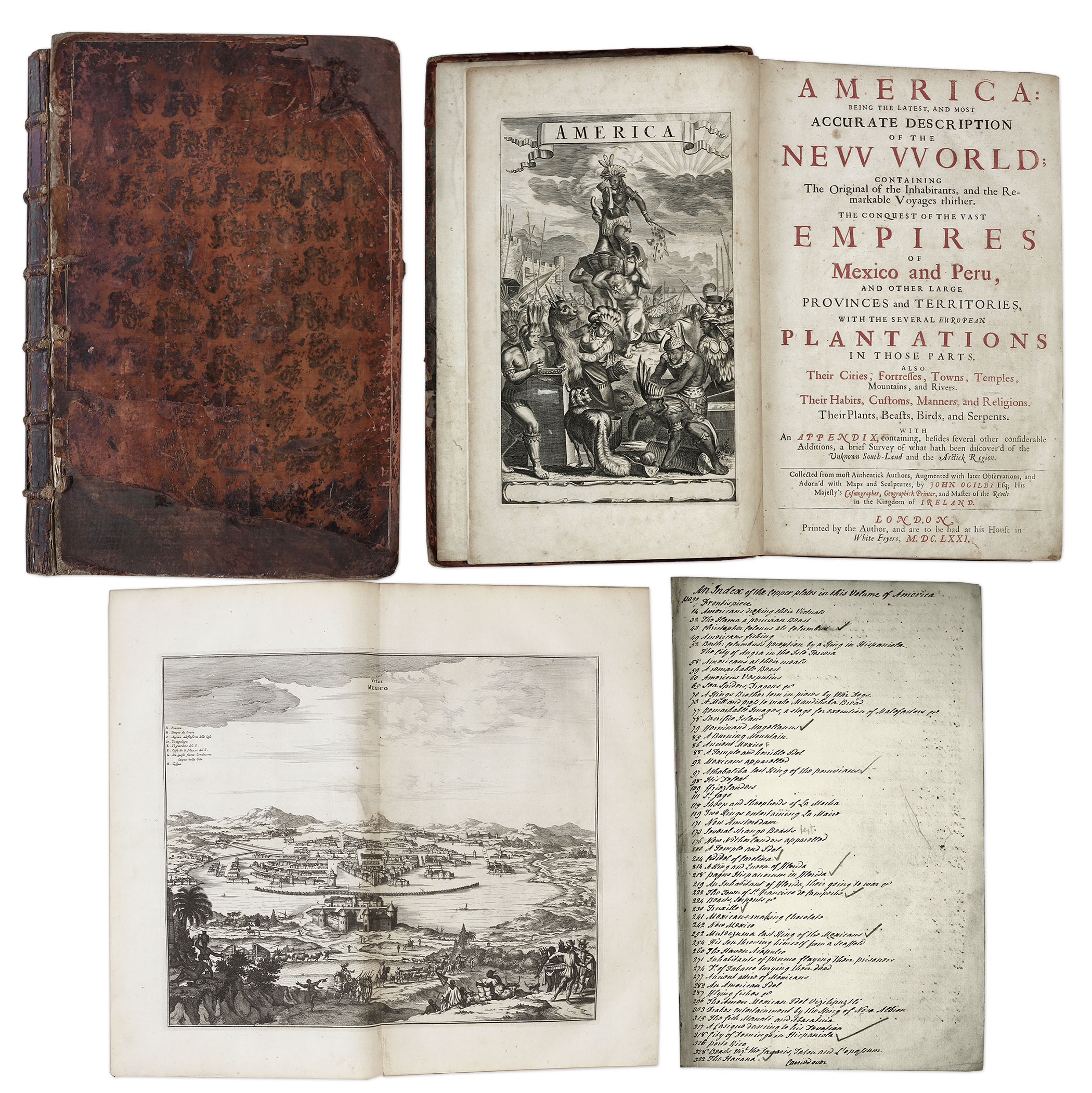
One of the most important books on the history of America (cited by Borba de Moraes, Howes, Sabin and Wing), the 1671 first edition of ”America: Being the Latest and Most Accurate Description of the New World”. Privately printed in London by the author, Arnoldus Montanus, and edited by John Ogilby. In ”America” Montanus goes into great detail of the new continents, with dozens of engravings of Native Americans, species of animals and reptiles, and the landscapes and settlements in the new world, accompanied by text. The book covers speculation regarding the earliest voyages to America, along with later recorded voyages and the settlements of New Netherlands/New York, New England, Hudson’s Bay, Labrador, Canada, Nova Scotia, Maryland, Virginia, (including Captain Smith’s capture and rescue by Pocahontas), Carolinas, Florida and California, plus accounts of Mexico and nearby islands, even including Australia and New Zealand. 674pp. book contains 75 original engravings (64 copper plates within the text and 9 plates throughout), lacking the maps and 28 engravings, which is typical as this edition is almost never found with all plates intact. All text is complete except for missing pages 445-446. Large format book measures 10” x 15”. Bound in original full leather boards, with some loss of leather to covers, cracking along spine and front board detached. Interior text is near fine and very readable. An important and fascinating addition to early knowledge of the American continent. Sold for $9,375.
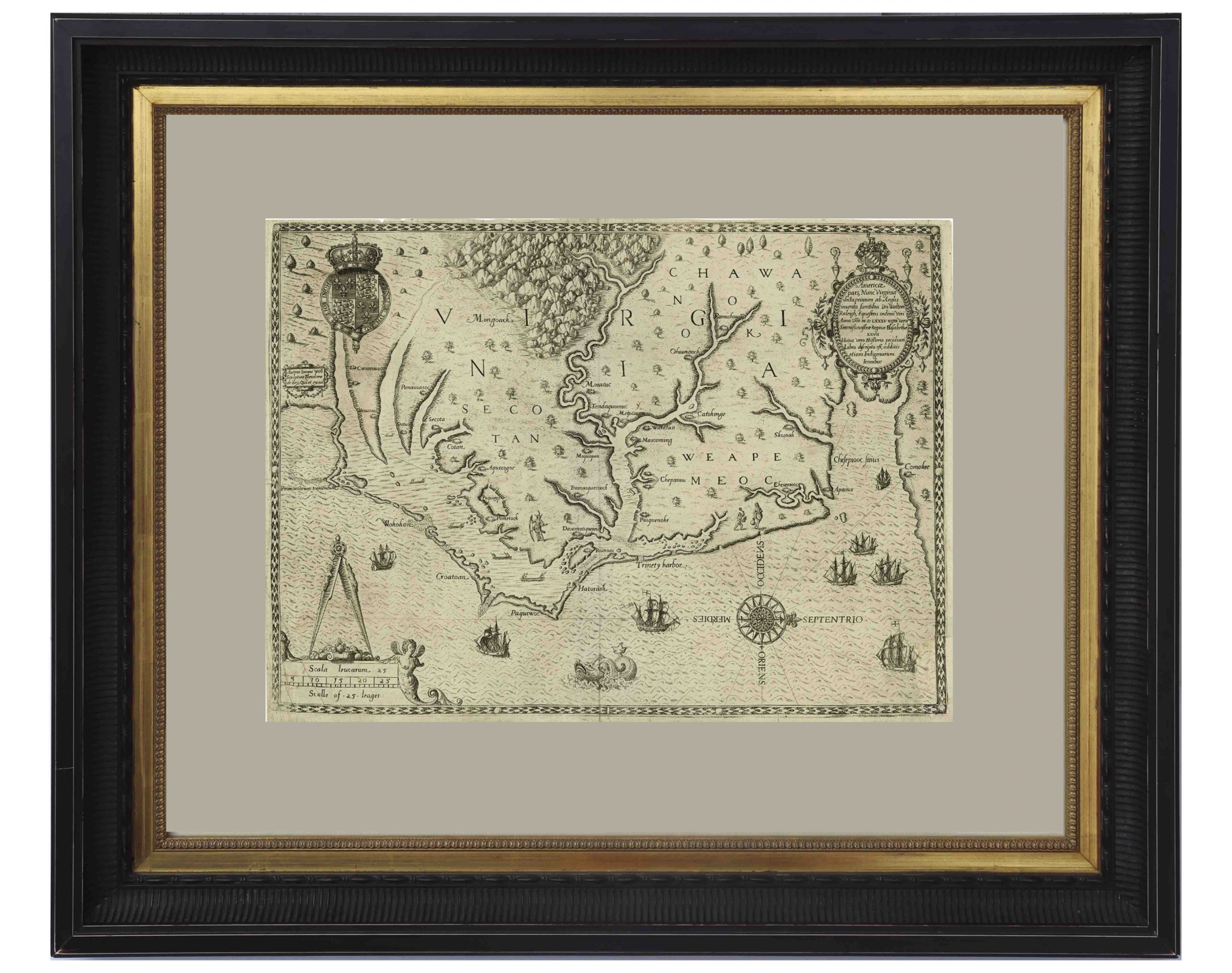
John White’s Map of Virginia From 1590 — The First Printed Map of Virginia and North Carolina
An important 16th century North American map known not only for its level of detail and accuracy, but also for its “firsts”: the first printed map of Virginia and North Carolina, the first to use Virginia in its title, the first to name the Chesapeake Bay, and also the first regional map showing the Roanoke Colony. Frankfurt: Theodor de Bry (engraver) for inclusion in his “Anglorum in Virginiam aduentus”, 1590.
Map is based on the work of cartographer, artist and explorer John White, one of the first settlers and Governor of the Roanoke Colony who, after sailing back to the Colony from England in 1587, had found all the colonists famously missing, their fate a mystery still unsolved. Philip Burden, who wrote the definitive reference book, “The Mapping of North America”, wrote of this map: “One of the most significant cartographical milestones in colonial North American history…the most accurate map drawn in the sixteenth century of any part of that continent.”
This full-sheet engraved map still retains its dark print, with the English Royal Arms at top left, and artistic touches throughout such as ships and sea monsters in the open ocean, and Native American canoeists in the inland waters. Map is the second state, with “C” laid over the “E” in Ehesepiooc. Map measures 16.675″ x 12.25″, nicely matted and framed to a size of 28″ x 23.5″. Expert repair to single vertical fold, and small area of repair to lower right corner, just touching the edge of the ship, where paper loss has been replaced. Overall in very good to near fine condition given age, displaying beautifully. Sold for $6,665.
Document signed by Jonathan Corwin, one of the judges overseeing the Salem Witch Trials, known for signing several arrest warrants associated with the Trials, and for conducting hearings where three of the accused women gave testimony. Document, dated 3 March 1700, is signed by Corwin in Salem as Probate Judge of Essex County, where he approves the will of John Poor, whose family has an interesting association with the Trials. John’s brother, Daniel Poor, was a constable in Salem during the Trials, and was given custody of Samuel and Sarah Wardwell’s child after they were both convicted of witchcraft in 1692. With intact wax-based paper seal, document measures 8.25” x 8”. Normal age wear with expected toning and foxing. Overall very good condition given age, with an exceptionally large, bold signature by Corwin. Sold for $6,250.

Salem Witch Trials Judge Thomas Danforth Document Signed From 1656 — Scarce
Document from the colony of Massachusetts signed ”Thomas Danforth”, one of the Judges of the infamous Salem Witch Trials. Decades after this document was drafted, Danforth would sit as a judge in the 1692 witch trials, though he actually opposed putting the purported witches on trial. Datelined Charlestown, 19 June 1656, the document is written by an unknown hand and reads in part: ”At a Coun[ty] Court hild at Charlestown, June 19th 1656: Whereas at the last Coun[ty] Court hild at Cambr[idge]: The Court granted unto Capt. Frances Norton a release from paying any further interest for the money he have in his hands of…Childwin…given by Capt. Norton to…Childwin for the payment not only of the principle, but also of the interest untill such time as this court shall give him…[signed] Thomas Danforth”. Danforth was a prominent colonial figure and founded the town of Framingham, Massachusetts. 1pp. measures 7.74” x 4.25”. Light toning, creasing and an irregular right edge, else in near fine condition, especially given age. Sold for $3,691.

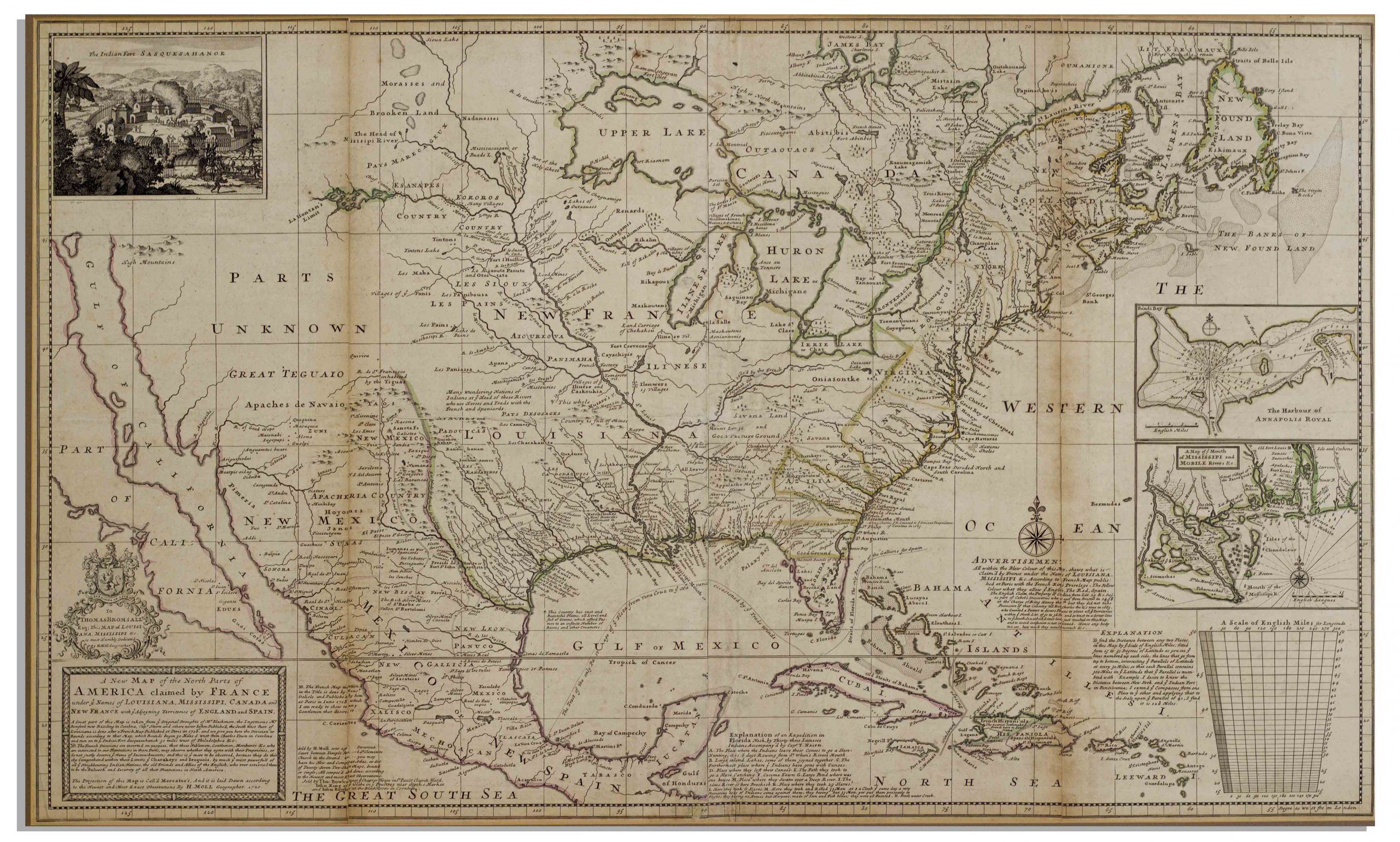
Herman Moll New Map of the North Parts of America
Large map of the Americas, published in 1720 by London cartographer Herman Moll entitled “A New Map of the North Parts of America claimed by France under ye names of Louisiana, Mississipi, Canada and New France with ye adjoyning territories of England and Spain”. Engraved map incorporates the latest surveying of the Americas, such as a French expedition into Texas in 1716. Map is hand-colored at boundaries, featuring a vignette at upper left of “The Indian Fort Sasquesahanok”, and with various “Explanations” of the map printed at bottom, including one of an Indian expedition into Florida, “6 days Rowing”. Insets of the Annapolis Harbor and the mouths of the Mississippi and Mobile Rivers are also included. Map is published in four vertical sections, laid down on archival paper and mounted on board. Map measures 25″ x 40.75″. Minor browning at section lines and a few spots of buckling. An attractive map in very good condition, giving historical insight into the jockeying for land among the major European powers in the early 18th century. Sold for $3,200.
John Speed Map of New England and New York 1676
The most famous 17th century map of New England, engraved by cartographer Francis Lamb with Anglican names for the first time reflecting the shift from Dutch to English rule, such as New York rather than New Amsterdam and “New Jarsey”. London: Basset and Chisswell, 1676, from the reissue of John Speed’s atlas, “The Theatre of the Empire of Great Britaine”, with new maps of the English colonies. Colorful double-page map entitled “A Map of New England and New York”, shows wildlife of the area in addition to topography and boundary lines. With English text on verso headlined, “The Description of New Neatherlands [sic] now called NEW-YORK” and “The Description of New England”. Engraved map measures 21″ x 17.125″, hinged at top to mat measuring 26.375″ x 21.375″. Slight offset along center fold, tape repair to verso, small separation at top center fold, and minute foxing. Overall very good plus condition. Sold for $1,800.

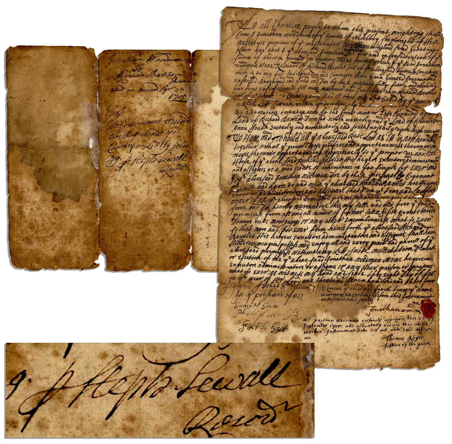
Clerk of Courts for the Salem Witch Trials, Stephen Sewall document signed in ink ”Steph Sewall” as recorder for Essex County. Twelve years prior, Sewall served as Clerk in the Court of ”Oyer & Terminer” in Salem Town, site of the most notorious of the collective ”Salem Witch Trials”. Lethal paranoia, accusations and trials swept three additional towns in colonial Massachusetts during the year of 1692-1693, during which nineteen people were ultimately executed for witchcraft. Handwritten document is dated 1705 and names Jonathan Woodman and Richard Bartlett Jr. as parties to a land sale contract. Sewall signs a panel to verso. Single-page document on card-style stationery is countersigned by Jonathan Woodman, Samuel Soyer, Philip Morss, Joseph Hoyt and Thomas Noyes. Remnants of a red wax seal appear to the lower right. Measures 7.5” x 11.75”. Foxing, toning, dampstaining and separation to folds. Good condition, especially given age. Sold for $938.
FREE APPRAISAL. To buy, auction, sell or consign your John Winthrop document signed that is for sale, please email your description and photos to [email protected] of Nate D. Sanders Auctions (http://www.NateDSanders.com).
We offer the following for your John Winthrop document signed:
- Appraise John Winthrop document signed.
- Auction John Winthrop document signed.
- Consign John Winthrop document signed.
- Estimate John Winthrop document signed.
- Sell John Winthrop document signed.