Sell or Auction Your Jean-Baptiste d’Après de Mannevillette Neptune 1775 for up to Nearly $30,000 or More at Nate D. Sanders Auctions
FREE ESTIMATE. To buy, auction, sell or consign your Jean-Baptiste d’Après de Mannevillette Le Neptune Oriental 1775 that is for sale, please email your description and photos to [email protected] of Nate D. Sanders Auctions (http://www.NateDSanders.com).
Free Appraisal, Auction or Sell Your Jean-Baptiste d’Après de Mannevillette Le Neptune Oriental 1775
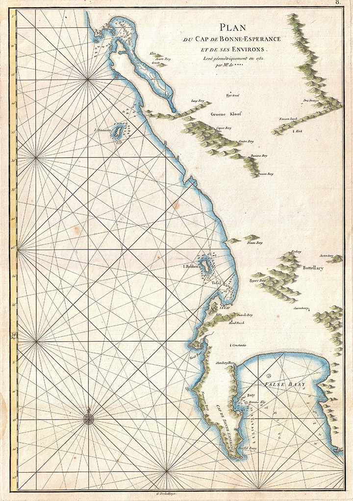
Below is a recent realized price for a copy of Jean-Baptiste d’Après de Mannevillette’s Le Neptune Oriental 1775 . We at Nate D. Sanders Auctions can obtain up to this amount or more for you:
Jean-Baptiste d’Après de Mannevillette Neptune 1775. Sold for Nearly $30,000.
The following are some prices we have realized for related memorabilia:
Gutenberg Bible Leaf — Scarce Leaf From the 15th Century Bible Made From Moveable Type That Ushered in the Age of Enlightenment
Scarce leaf from the Gutenberg Bible, one of the earliest major books printed from moveable metal type, the invention that ushered in the Age of Enlightenment by democratizing knowledge through mass production of literature. Printed by Johannes Gutenberg in Mainz, Germany from 1450-1455, less than 50 complete or near-complete copies of the Gutenberg Bible are now extant, with nearly all those housed in public institutions. Singular leaves are also scarce, with the leaf presented here having been acquired by bookseller Gabriel Wells, whose purchase of an incomplete Bible in 1920 gave way to selling the individual leaves alongside an essay by A. Edward Newton entitled “A Noble Fragment”. Leaf is number 193 of the full Latin Bible, with the recto being the Prologue to 1 Chronicles of the Old Testament, and the verso the first part of Chapter 1 of 1 Chronicles. Each page features two columns of 42 lines in dark black Gothic type, accented by red and blue rubrication. Each copy of the Gutenberg Bible differs in its rubrication and illumination, with buyers at the time deciding upon these embellishments after the Bible was printed. The six-line rubricated letters of this leaf were likely added later, restored to match the original style. Leaf measures 11.125″ x 15.375″, bound on edge to portfolio measuring 11.75″ x 16″. Paper quality is still bright with very little foxing or discoloration compared to other examples. A stunning example from the book that changed the course of history. Sold for $136,500.

Scarce 1493 First Edition of “Nuremberg Chronicle”, the Lavishly Illustrated High Point of Printing in the Age of Incunable, Published Shortly After the Gutenberg Bible
Scarce first edition, first printing of “Liber Chronicarum” or “Nuremberg Chronicle”, the 15th century illustrated history of the world, widely considered the high point of printed books in the post-Gutenberg incunable era. Nuremberg: Anton Koberger for Sebald Schreyer and Sebastian Kammermeister, 12 July 1493. Written by the Nuremberg doctor and humanist Hartmann Schedel, and largely illustrated by Michael Wolgemut’s workshop, with many views reportedly completed by Albrecht Durer, who apprenticed with Wolgemut at the time. Sold for $31,500.

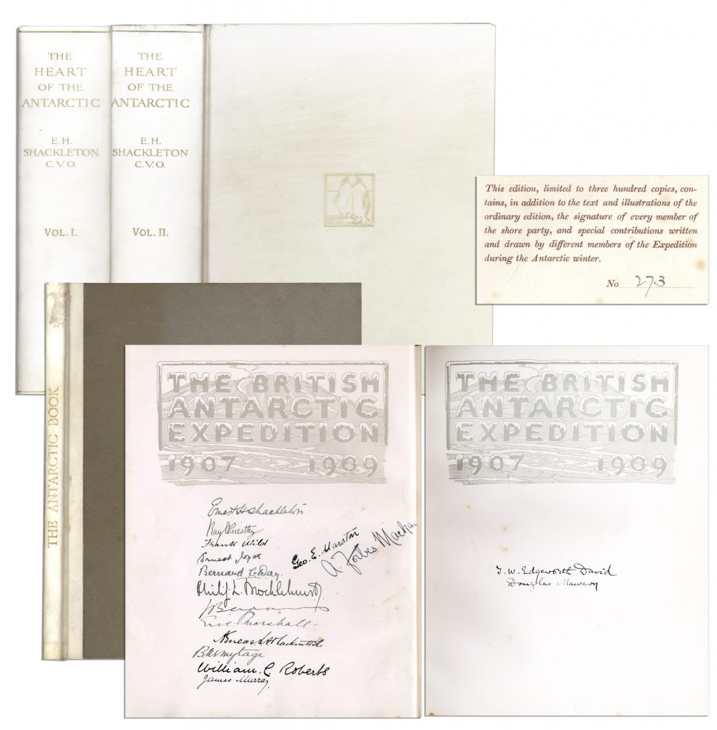
Ernest Shackleton & Crew Signed “The Heart of the Antarctic. Being the Story of the British Antarctic Expedition 1907-1909” Limited to Just 300 Copies, This Being All Three Volumes — Scarce
Ernest Shackleton’s signed copy of “The Heart of the Antarctic. Being the Story of the British Antarctic Expedition 1907-1909, 3 volumes (including “The Antarctic Book Winter Quarters 1907-09”), limited to 300 copies (here #273), also with signatures of the entire Shore party. Photogravure frontispiece, numerous plates (including 6 etched plates by George Marston, 16 tipped-in color after George Marston, others mostly photographic), one folding panorama and three folding lithographed maps in pocket at the end of volume three, illustrations and diagrams in the text. In publisher’s vellum, blocked in gilt with design of two penguins and top edges gilt. Occasional light spotting and small tear on cover of volume two. Overall in very good to near fine condition, signed by the Nimrod Shore Party crew. Sold for $12,718.
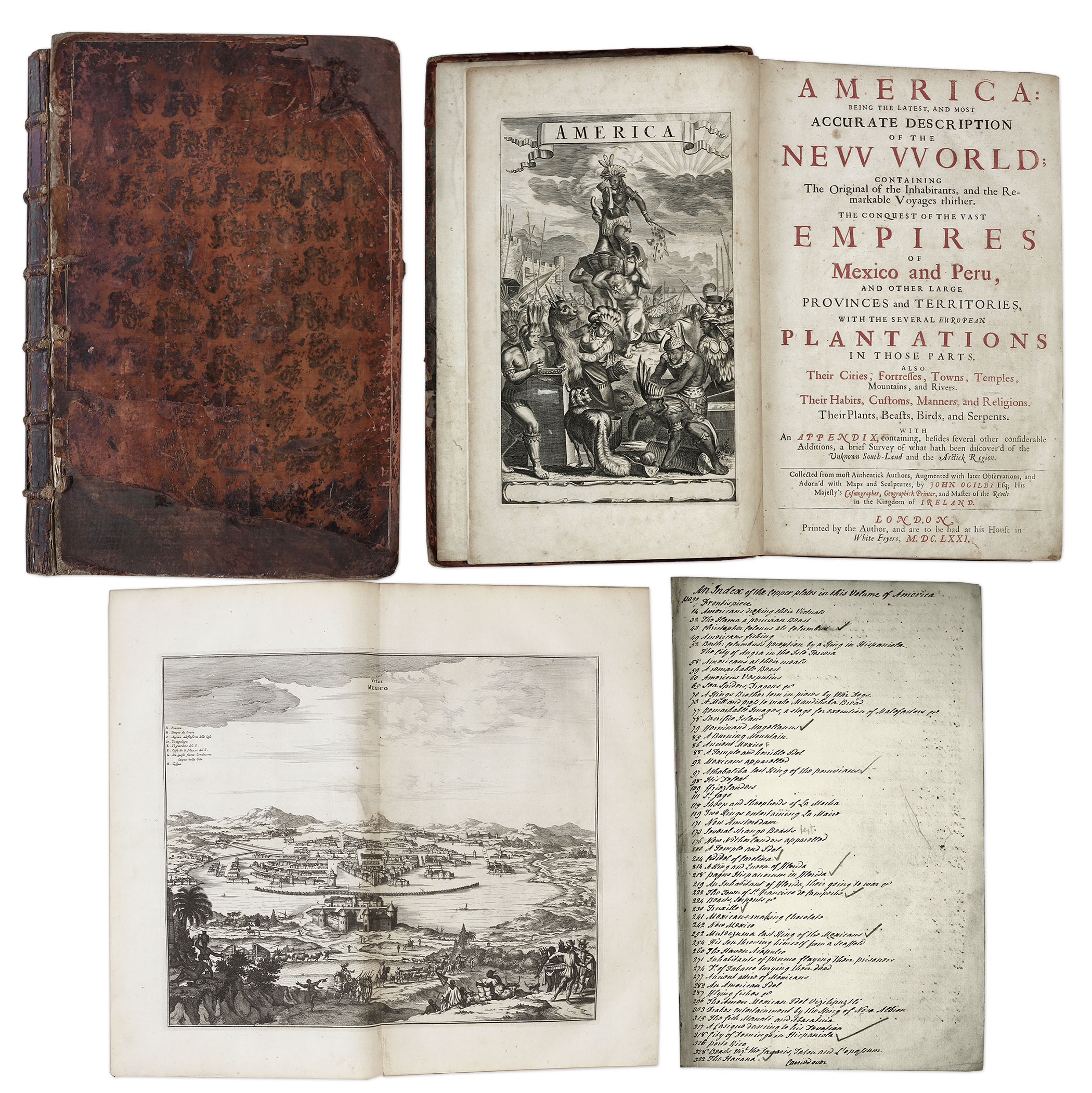
One of the most important books on the history of America (cited by Borba de Moraes, Howes, Sabin and Wing), the 1671 first edition of ”America: Being the Latest and Most Accurate Description of the New World”. Privately printed in London by the author, Arnoldus Montanus, and edited by John Ogilby. In ”America” Montanus goes into great detail of the new continents, with dozens of engravings of Native Americans, species of animals and reptiles, and the landscapes and settlements in the new world, accompanied by text. The book covers speculation regarding the earliest voyages to America, along with later recorded voyages and the settlements of New Netherlands/New York, New England, Hudson’s Bay, Labrador, Canada, Nova Scotia, Maryland, Virginia, (including Captain Smith’s capture and rescue by Pocahontas), Carolinas, Florida and California, plus accounts of Mexico and nearby islands, even including Australia and New Zealand. 674pp. book contains 75 original engravings (64 copper plates within the text and 9 plates throughout), lacking the maps and 28 engravings, which is typical as this edition is almost never found with all plates intact. All text is complete except for missing pages 445-446. Large format book measures 10” x 15”. Bound in original full leather boards, with some loss of leather to covers, cracking along spine and front board detached. Interior text is near fine and very readable. An important and fascinating addition to early knowledge of the American continent. Sold for $9,375.
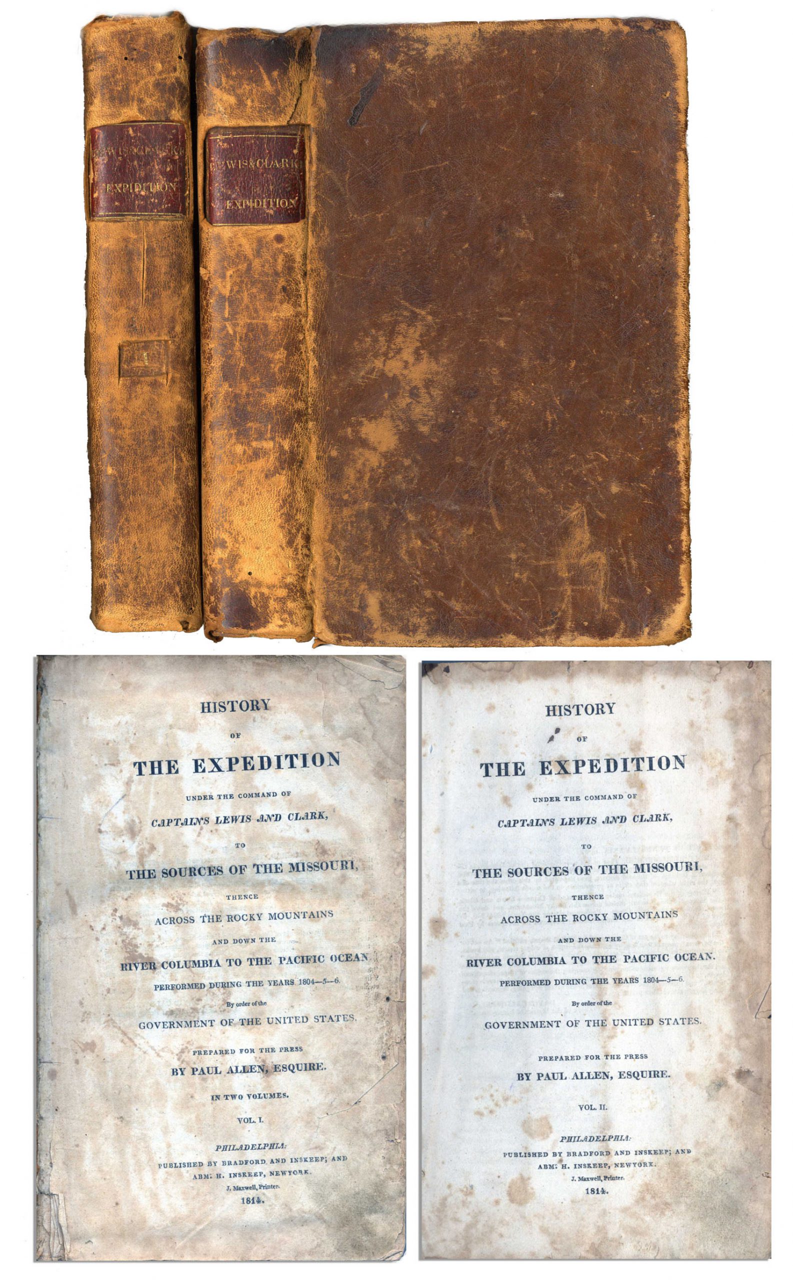
First edition, two-volume set of ”History of the Expedition under the Command of Captains Lewis and Clark to the source of the Missouri thence across the Rocky Mountains and down the river Columbia to the Pacific Ocean performed during the years 1804-05-06 by Meriwether Lewis and William Clark”. Published by Bradford and Inskeep: New York: 1814. Regarded as the definitive account of the first exhaustive, and most important Western exploration of America, which covered some eight thousand miles in slightly more than twenty-eight months. Lewis and Clark brought back the first reliable information about much of the area they traversed, made contact with the Native Americans as a prelude to the expansion of the fur trade, and advanced the geographical knowledge of the continent. This official account of the expedition is as much a landmark in Americana as the trip itself. Books, each measuring 5.5” x 8.75”, are bound in original marble-patterned leather boards and have five engraved, bound-in maps, missing the fold-out map found in some copies. Covers are worn and scuffed and the inside of covers have insect channels. Vol. I, 470pp., is missing the front free endpaper and has a chip out of the title page. Volume II runs 522pp. Light foxing and dampstaining throughout both volumes and some paper loss not affecting text. Overall in very good condition. An attractive set of America’s most important exploration narrative. Sold for $6,544.
Revolutionary War Map 1776
Revolutionary War map dated March 1776. “The Theatre of War in North America, With the Roads and a Table of the Distances…” Printed in London for R. Sayer and J. Bennett. Map depicts the area east of the Mississippi River from James Bay to Cape Canaveral, and locates provincial boundaries, towns, forts, roads, Indian villages, New England fishing waters, and the like. An inset is comprised of “Evan’s Polymetric Table of America,” which allows one to calculate the distance between most of the prominent towns. Text below the map reads, “A Compendious Account of the British Colonies in North America,” which devotes a paragraph of description to each of the North American colonies, including Florida, Canada, and the Province of Quebec. Issued separately by Sayer and Bennett, who also published “the American Military Pocket Atlas,” that year for the use of British officers. A notable map of the American Revolution, published the same year as the American Declaration of Independence. 20.75″ x 28.5″; 29.25″ x 37.5″ framed. Excellent condition. Sold for $6,000.

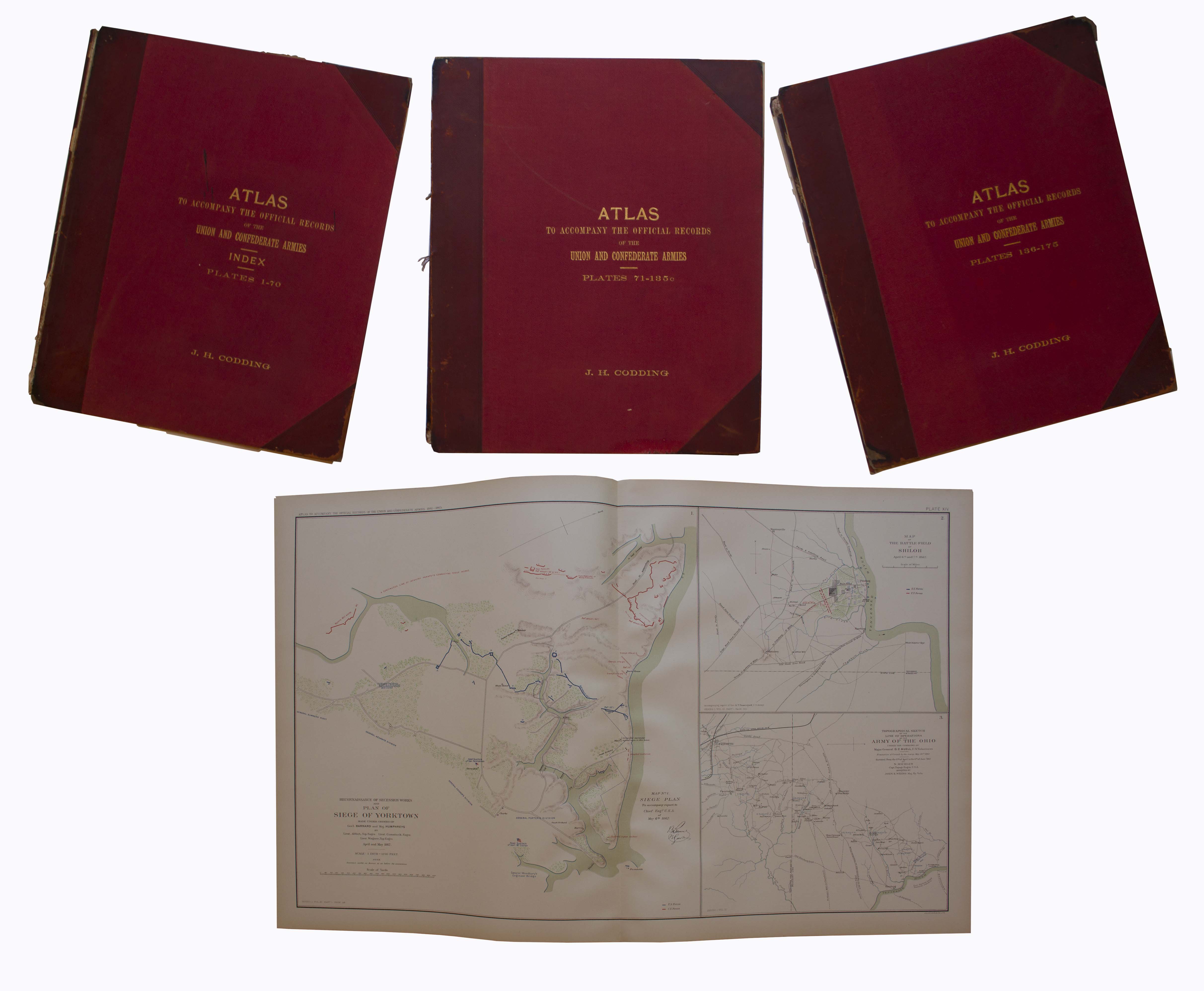
Three volume set of the ”Atlas to Accompany the Official Records”, compiled by Capt. Calvin D. Cowles. Washington, D.C.: U.S. Government Printing Office, 1891-1895. This three volume set of maps and drawings was printed to accompany the most comprehensive primary reference for the Civil War: ”War of the Rebellion: Official Records of the Union and Confederate Armies”, published by the U.S. Government in 53 volumes. All 175 plates are present here, with detailed schematics of battlegrounds, troop movements, examples of uniforms, transportation methods etc. Set is bound in original three-quarter red leather and maroon cloth, with marbled endpapers. Separated front board on Vols. 1 and 2, scuffing to boards and some loss to leather of spines, especially on Vol. 1. Maps and drawings, however, are in very good to near fine condition, with virtually no toning. Sold for $2,000.
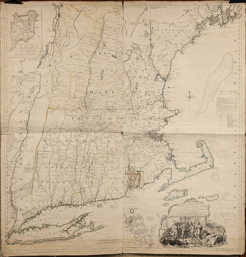
1774 Map of New England measuring over 40” square, the earliest large scale map of the New England colonies and used in the American Revolution. Drawn by Braddock Mead, and originally published in 1755, this copy was included in Thomas Jefferys’ ”American Atlas”, with hand-outlines. London: Printed and sold by R. Sayer and J. Bennett, 1776 (map dated 1774). Entitled in full, ”A Map of the Most Inhabited Part of New England Containing the Provinces of Massachusetts Bay and New Hampshire, with the Colonies of Connecticut and Rhode Island, Divided into Counties and Townships: The whole composed from Actual Surveys and its Situation adjusted by Astronomical Observations.” Measures 40” x 41.25”. Folded in fourths, as printed by copper-plate engraving on laid paper, mounted to linen. Light toning, chipping along margins and separation starting along folds. Overall in very good condition, a bright copy ideal for framing. Sold for $1,875.
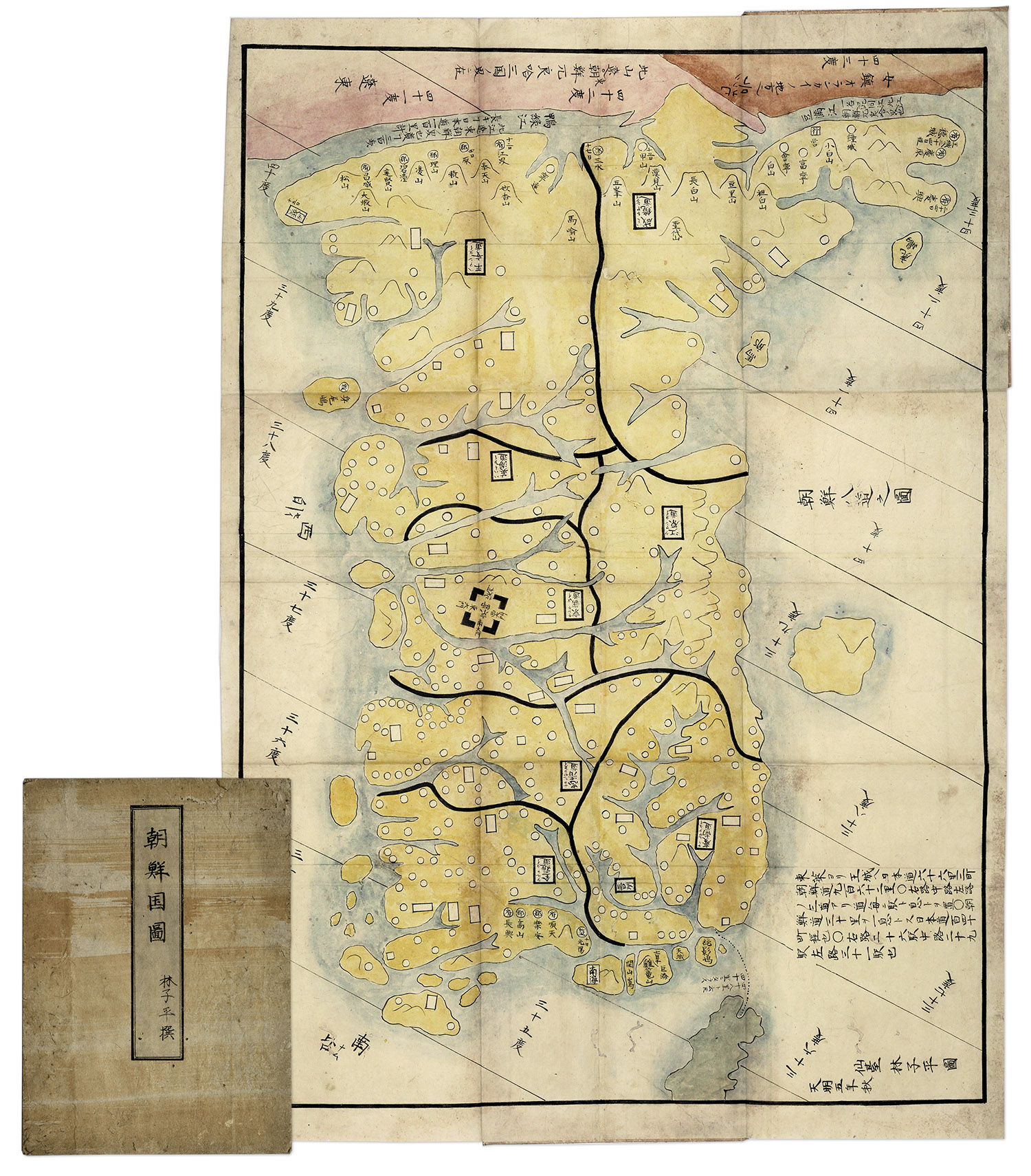
Hand-painted map of Korea by Hayashi Shihei, from Japan, circa 1785. Fold-out map shows the kingdoms outside Japan’s boundaries, but with the Kingdom of Joseon (Korea) being an important trading partner, the map was considered dangerous, and consequently banned by the Shogun in 1792. Has original cover boards and title slip. Measures 20” x 29” when folded out, and 7” x 9.5” when closed. Lightly toned and soiled, overall very good condition. Sold for $1,563.
FREE ESTIMATE. To buy, auction, sell or consign your Jean-Baptiste d’Après de Mannevillette Le Neptune Oriental 1775 that is for sale, please email your description and photos to [email protected] of Nate D. Sanders Auctions (http://www.NateDSanders.com).
We offer the following services for your Jean-Baptiste d’Après de Mannevillette Le Neptune Oriental 1775:
- Appraise Jean-Baptiste d’Après de Mannevillette Le Neptune Oriental 1775.
- Auction Jean-Baptiste d’Après de Mannevillette Le Neptune Oriental 1775.
- Consign Jean-Baptiste d’Après de Mannevillette Le Neptune Oriental 1775
- Sell Jean-Baptiste d’Après de Mannevillette Le Neptune Oriental 1775.