Sell or Auction Your Lewis Evans Geographical Printed by B Franklin 1756 for up to $30,000 or More at Nate D. Sanders Auctions
FREE ESTIMATE. To buy, auction, sell or consign your Lewis Evans Geographical Printed by B Franklin 1756 that is for sale, please email your description and photos to [email protected] of Nate D. Sanders Auctions (http://www.NateDSanders.com).
Free Appraisal, Auction or Sell Your Lewis Evans Geographical Printed by B Franklin 1756
Lewis Evans (c. 1700 – 12 June 1756) was a Welsh surveyor and geographer. He had a brother John. In the mid-1730s he emigrated to British America, where he was based in Philadelphia. He was well known for his 1755 map of the Middle British Colonies.
Below is a recent realized price for a Lewis Evans Geographical Printed by B Franklin 1756. We at Nate D. Sanders Auctions can obtain up to this amount or more for you:
Lewis Evans Geographical Printed by B Franklin 1756. Sold for Nearly $30,000.
The following is some historical memorabilia we sold:
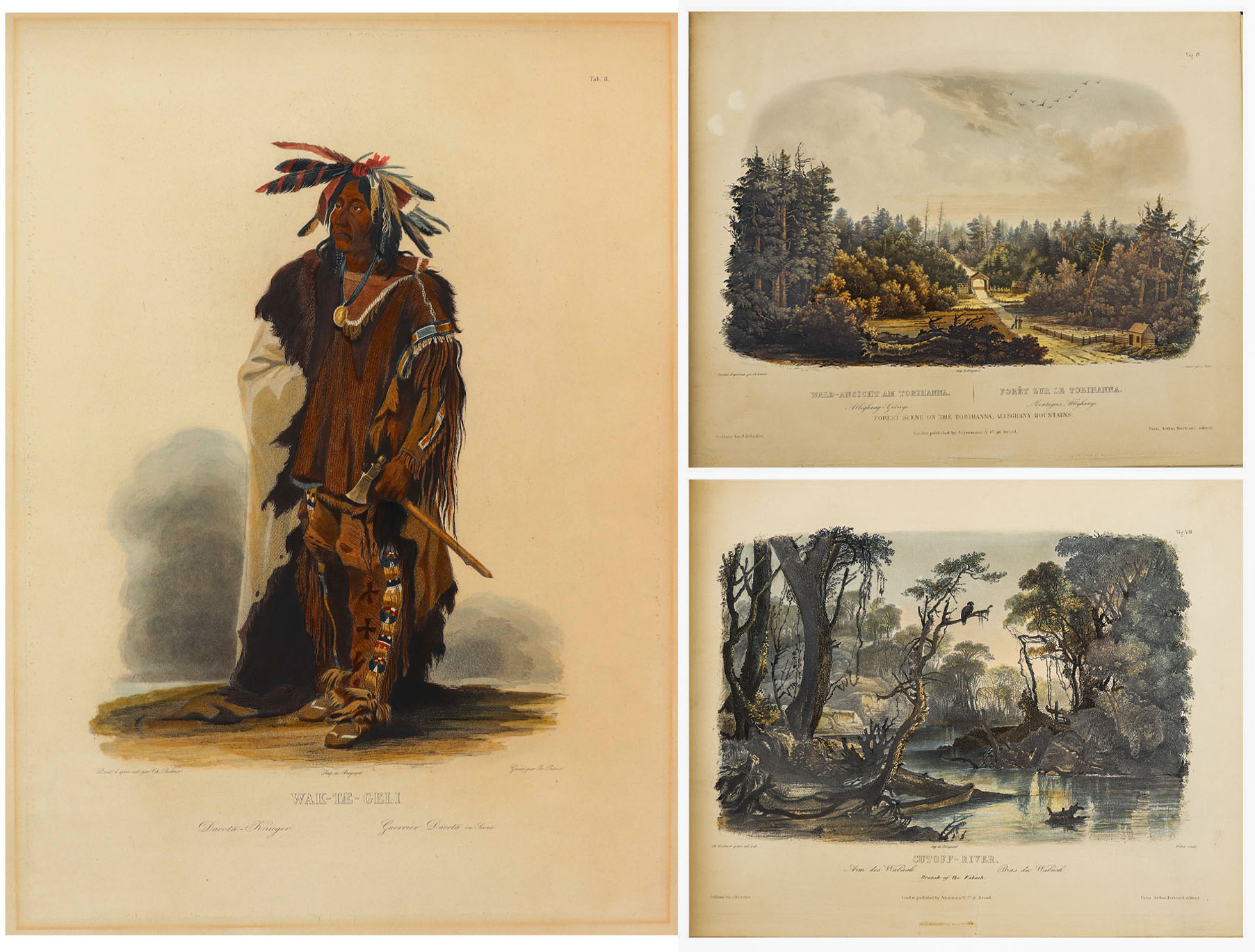
81 Beautiful Hand-Colored Aquatints by Karl Bodmer Depicting the American Frontier in the 1830s — Contained in the Illustrated Travelogue “Prince of Wied’s Travels in the Interior of North America”
Stunningly beautiful collection of 81 hand-colored aquatints by the Swiss artist Karl Bodmer, a complete collection from the illustrated travelogue, “Prince of Wied’s Travels in the Interior of North America”. Bodmer, who journeyed with the German Prince Maximilian of Wied-Neuwied from 1833-34 along the Missouri River, produced what is considered the best depictions of the indigenous peoples and landscapes during the frontier era, an America then still unspoiled by western migration. Of the Native American tribes of the Great Plains that they encountered, Bodmer’s depictions of the Blackfeet and Mandan tribes are especially important as the populations of these tribes were greatly affected by the smallpox epidemic of 1837, thus making Bodmer’s work the last visual testament to their culture.
Prince Max, as he was called, chose Bodmer to accompany him on the expedition along the Missouri River to visually depict the scenes that the Prince would write about. The result is this collection: three volumes of text by the Prince and two volumes of aquatints by Bodmer, in the first Paris edition published by Chez Arthus Bertrand, 1840-43 (“Voyage dans l’interieur de l’Amerique du Nord”). Text volumes in French also include 37 wood-engraved illustrations, only lacking the map in completeness. The two complete volumes of illustrations include the large folio volume with 48 oversized hand-colored aquatints measuring approximately 24.5″ x 18″, and the quarto volume with 33 hand-colored aquatints measuring approximately 12.5″ x 10.25″. The complete set of 81 aquatints is magnificent in their display, a time capsule with their hand-coloring evoking the sense of awe and discovery of the expedition. All volumes are bound in half black morocco and blue paper-covered boards with gilt accenting, and with black morocco labels to illustrated volumes. Minor handling wear to volumes, with a few small repaired tears to plates, some plates supplied with variance to margins, minute toning and foxing, a few plates beginning to separate from binding. Overall a very good plus set with excellent display quality. Sold for $175,000.


Scarce collection of 63 photographs from Carleton Watkins’ groundbreaking publication, ”Yosemite Valley: Photographic Views of the Falls and Valley of Yosemite in Mariposa County, California”. San Francisco, 1863. One of the most complete collections, lot comprises a total of 63 photographs, with two of the title page and map, and 61 of the Yosemite Valley, each measuring 11.625” x 7.5”. Scarce as such.
Lured out to California for the Gold Rush, Watkins soon turned his pursuits to photography, a calling for which he was naturally gifted. In 1861, he traveled to Yosemite outfitted with both mammoth-plate and stereoscopic cameras to make the first photographic narrative of the majestic valley, with these photographs the result. They were so impactful, after having been shared amongst Congressmen and Abraham Lincoln, that the Yosemite Grant Act was passed in 1864, a precursor to the creation of the U.S. National Park System in 1872.
Interestingly, no complete accounting of Watkins’ Yosemite photos from 1863 is documented, but next to a collection of 65 photographs, this grouping is the most complete at 63 photographs. Only a handful of other collections even claim more than 50 photographs. The views are exquisite, capturing the rock formations, foliage and natural water sources of the Valley as they appeared in 1861, yet unspoiled by overcrowding. Watkins’ ability to capture the depth of the images – with distant mountains hovering over meadows and streams, is particularly beautiful, aided by the use of his two camera systems.
Photographs retain superb contrast and tonality, all disbound in a period brown morocco gilt slipcase, tooled in gilt on the cover, ”Watkins’ Yosemite Gallery.” Overall in very good to near fine condition. Sold for $112,500.

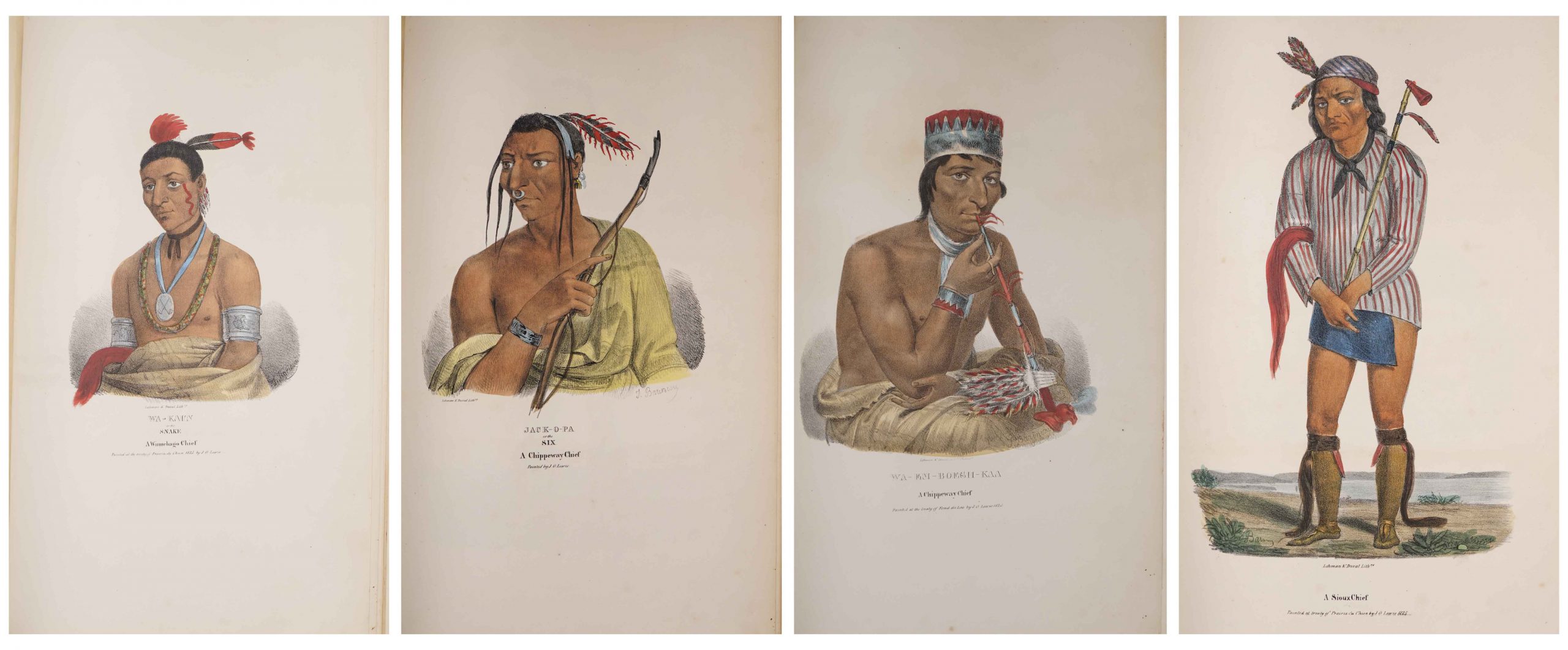
Complete Set of 80 Hand-Colored Lithographs of “The Aboriginal Port Folio” by James Otto Lewis From 1835-1838 — Extremely Scarce Complete Set
Very scarce complete set of the “Aboriginal Port Folio”, containing 80 hand-colored lithographs by Native American visual chronicler James Otto Lewis, whose travels to various treaty ceremonies during the early 19th century produced lasting portraits of Native American leaders and customs. Lewis was the first to create such artwork, preceding McKenney & Hall by several years. Philadelphia: George Lehman and Peter S. Duvall, 1835-1838.
After painting portraits of members from the Sioux, Potawatomi, Winnebago, Fox, Shawnee, Miami, and Iowa tribes, Lewis brought his paintings to Philadelphia for lithography, releasing them by subscription in 10 installments of 8 lithographs apiece. Each installment grew more scarce as subscriptions trailed off with the impending publication of the more comprehensive (and more formally posed) “History of the Indian Tribes of North America” by McKenney & Hall, whose portrait artist Charles Bird King even copied some of Lewis’ paintings. As a result, the full collection of 80 lithographs of “The Aboriginal Port Folio” is so scarce that only five to ten copies are known to exist. To make matters worse, Lewis’ original paintings were destroyed in the Smithsonian fire in 1865.
This set is in very good to near fine condition, with only minor scattered foxing affecting some sheets. In addition to the 80 pictorial lithographs, set also includes the lithograph title page and three leaves of advertisements, making it a truly complete set. Lithographs each measure 11.5″ x 18.125″, housed in three-quarter red morocco clamshell case with custom lettering to spine. One of the few visual remembrances of this important collection preserved for history. Sold for $84,000.

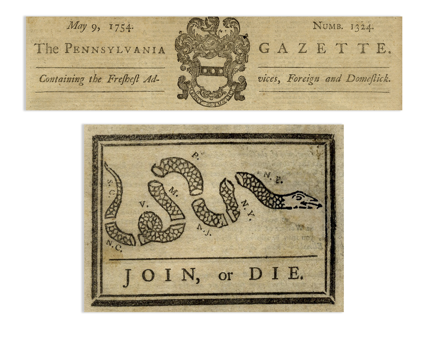
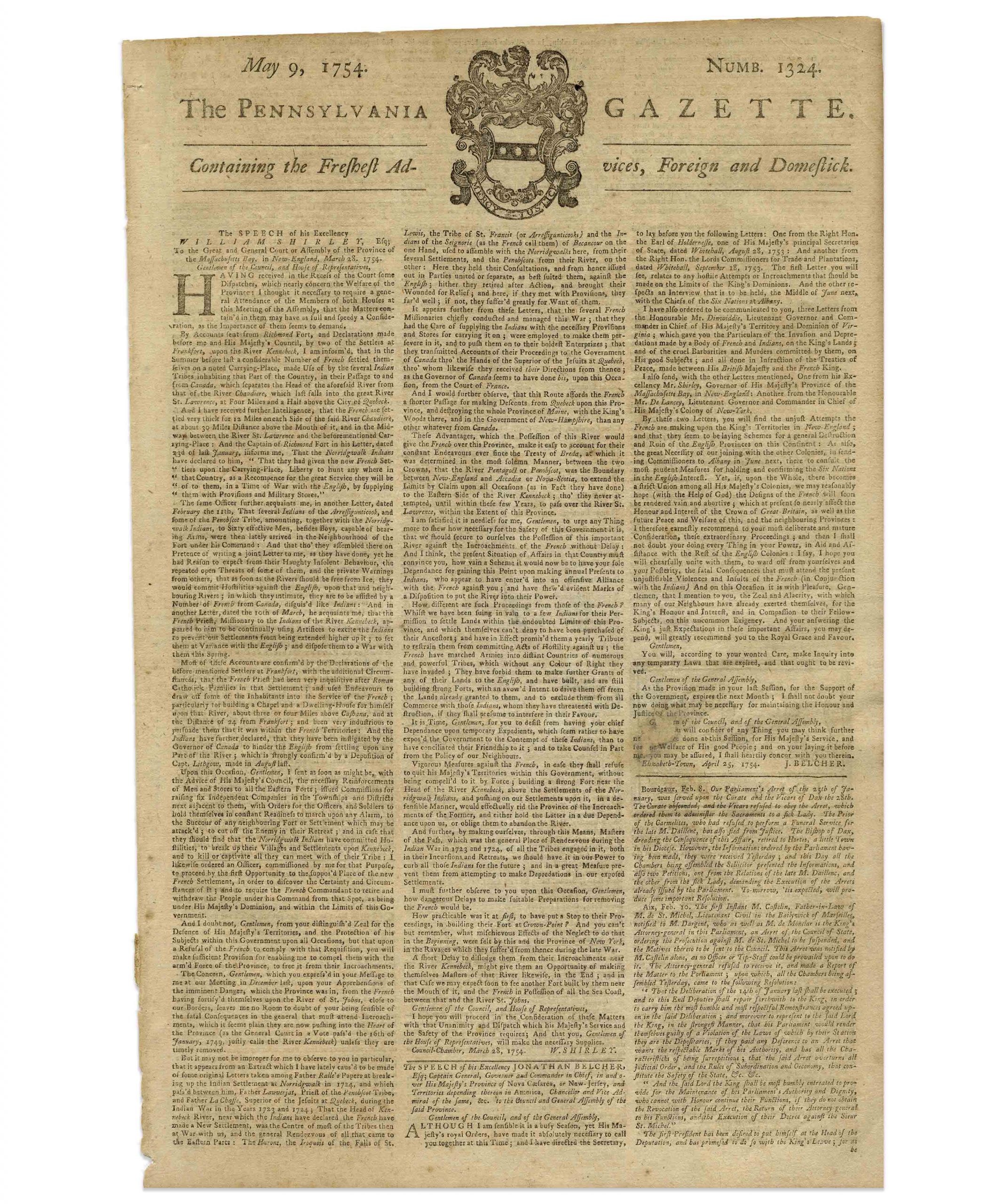
The most influential political cartoon in the history of America, the ”JOIN, or DIE” severed rattlesnake designed by Benjamin Franklin and published in his ”Pennsylvania Gazette” on 9 May 1754. This incredibly scarce newspaper is the very first printing of the ”JOIN, or DIE” cartoon, and the only known copy apart from one other housed in the permanent collection at the Library of Congress.
Frustrated by the colonists’ inability to join forces against westward expansion by the French, Franklin created this cartoon of a rattlesnake, cut into 8 pieces symbolizing the American colonies, to dramatically impart the effective message: join together as one cohesive body, or die. Along with the cartoon, Franklin published an editorial in the newspaper, urging the colonists to work together, reading in part, ”…The Confidence of the French in this Undertaking seems well-grounded on the present disunited State of the British Colonies…while our Enemies have the very great Advantage of being under one Direction, with one Council, and one Purse…”
Little did Franklin know at the time that his symbol of the dis-united rattlesnake would echo over twenty years later to inspire the colonists to unite against the British – Paul Revere added the ”JOIN, or DIE” cartoon to the nameplate of his paper, the ”Massachusetts Spy”, and even later, with the ”Don’t Tread on Me” flag, any individual or group whose personal liberty is threatened. The phrasing has also proved highly enduring, likely influencing John Stark, the Revolutionary War General from New Hampshire whose toast, ”Live free or die: Death is not the worst of evils”, inspired New Hampshire’s motto, and again suggests that personal liberty is one of the highest human values, and a founding tenet of the United States.
Franklin’s choice of a rattlesnake is curious for several reasons: as the timber rattlesnake was found throughout the colonies but not England, Franklin argued in an earlier 1751 editorial that the colonists should ship rattlesnakes to England in exchange for the criminals that England was sending to America. Franklin now, however, seems to fully embrace the rattlesnake as metaphor, and would argue, during the American Revolution, its virtues. Using a pseudonym to conceal his identity, he wrote in 1775, ”…she has no eye-lids-She may therefore be esteemed an emblem of vigilance.-She never begins an attack, nor, when once engaged, ever surrenders…to those who are unacquainted with her, she appears to be a most defenseless animal; and even when those weapons are shown and extended for her defense, they appear weak and contemptible; but their wounds however small, are decisive and fatal:-Conscious of this, she never wounds till she has generously given notice, even to her enemy, and cautioned him against the danger of stepping on her.-Was I wrong, Sir, in thinking this a strong picture of the temper and conduct of America?”
While the British loyalists played upon Franklin’s symbolism of the rattlesnake, arguing that the colonists were deceptive and cunning, Franklin turned the characterization on its head, skilled and interested as he was in the art of propaganda. Ultimately, the symbolism would prove highly enduring and compelling: both the idea of uniting to fight a greater, more powerful enemy, and the power of a sudden, deadly attack by an underestimated opponent.
Four page newspaper (without advertising) measures 9.75” x approximately 15”, with an irregularly trimmed top edge. Expert restoration to head of snake, and light uniform toning, consistent with age. Newspaper has been well-preserved, in very good to near fine condition. One of the most important newspapers in America’s colonial history and a cornerstone of her philosophical underpinnings. Sold for $50,000.
Very scarce Meriwether Lewis document signed ”Meriwether Lewis Capt. / 1st U’S. Regt. Infty.” Single octavo page, dated 12 February 1807 reads in full: ”Received February 12th 1807 of Caleb Swan Paymaster of the Army of the United States, Two hundred dollars, in pursuance of a warrant from General Henry Dearborn Secretary of War, No. 1003, being on account of my pay and subsistence, for which sum I am accountable to the Accountant of the Department of War, having signed duplicates hereof. 200 Drs.” In January 1803, President Thomas Jefferson sought to learn more about the far western territory, and appropriated the money from Congress for the proposed journey, to be led by the experienced explorer Meriwether Lewis. In his memoirs, Jefferson wrote of Lewis: ”Of courage undaunted; possessing a firmness and perseverance of purpose which nothing but impossibilities could divert from its direction; careful as a father of those committed to his charge, yet steady in the maintenance of order and discipline; intimate with the Indian characters, customs, and principles; habituated to the hunting life; guarded by exact observations of the vegetables and animals of his own country against losing time in the description of objects already possessed; honest, disinterested, liberal, of sound understanding, and a fidelity to truth so scrupulous that whatever he should report would be as certain as seen by ourselves…” (”History of the Expedition,” 1814). In the months immediately preceding the expedition, Lewis sought training in the use of astronomical instruments and in the art of map-making. He also chose a companion officer, William Clark of Louisville. While the expedition did not achieve the primary objective of finding the elusive Northwest Passage, it contributed significantly to the understanding of the geography of the Northwest and produced approximately 140 maps, the first accurate maps of the area. In addition, it documented 100 newly discovered species of animals, approximately 170 plants, and it also established friendly relations with three dozen Indian tribes. The knowledge they obtained sparked American interest in the west, and strengthened the nation’s claim to the area. Meriwether Lewis returned to Washington, D.C. from his three year journey in late December of 1806. After returning from the expedition, Lewis received a reward of 1,600 acres of land. In addition, Thomas Jefferson appointed him Governor of the Louisiana Territory. However, Lewis was not confirmed by the Senate until March 1807 and he remained a Captain in the interim. Base pay for Captains at this period was $40 per month so the present receipt would represent five months’ salary. A supremely rare document directly linking Meriwether Lewis to the Lewis & Clark Expedition. Items of Lewis & Clark related to the famed expedition are of the utmost rarity. Docketed on verso. Toning to folds and showthrough, otherwise near fine condition. Sold for $30,768.

Ernest Shackleton & Crew Signed “The Heart of the Antarctic. Being the Story of the British Antarctic Expedition 1907-1909” Limited to Just 300 Copies, This Being All Three Volumes — Scarce
Ernest Shackleton’s signed copy of “The Heart of the Antarctic. Being the Story of the British Antarctic Expedition 1907-1909, 3 volumes (including “The Antarctic Book Winter Quarters 1907-09”), limited to 300 copies (here #273), also with signatures of the entire Shore party. Photogravure frontispiece, numerous plates (including 6 etched plates by George Marston, 16 tipped-in color after George Marston, others mostly photographic), one folding panorama and three folding lithographed maps in pocket at the end of volume three, illustrations and diagrams in the text. In publisher’s vellum, blocked in gilt with design of two penguins and top edges gilt. Occasional light spotting and small tear on cover of volume two. Overall in very good to near fine condition, signed by the Nimrod Shore Party crew. Sold for $12,718.

Beautiful and scarce Pilgrim document from 17th century colonial America. Dated 1670, document confirms the sale of 50 acres of land in Marshfield, Plymouth County, Massachusetts by John Rogers to William Macomber. Document is signed by a veritable who’s-who of Pilgrim notables, including Rogers, Nathaniel Morton, Constant Southworth and James Toale (Towle). In addition to writing the first historical text published in the United States (about the settlement of the Plymouth Colony) Nathaniel Morton was the first to publish a list of signers of the Mayflower Compact and also wrote his account of the first Thanksgiving. He served for most of his life as Secretary of Plymouth Colony, where his careful record-keeping enabled him to compile New England’s Memorial, considered the first comprehensive history of the colony, published at Cambridge in 1669, and widely considered the first book of history published in the United States. In fact, ”The Wall Street Journal” has published an excerpt from Morton’s history of Plymouth Colony as an op-ed the Wednesday before Thanksgiving Day since 1961. Constant Southworth came to Plymouth in 1628 as a teenager, and held several prominent positions during his life, including Treasurer of the Colony. John Rogers was born in 1642 in Plymouth County, the son of a Mayflower passenger. Document measures approximately 15.5” x 12” with some paper loss to lower right. Some expected foxing and toning, small amount of paper loss and archival tape repair to verso. In very good condition considering age, with still bold writing. Sold for $10,000.

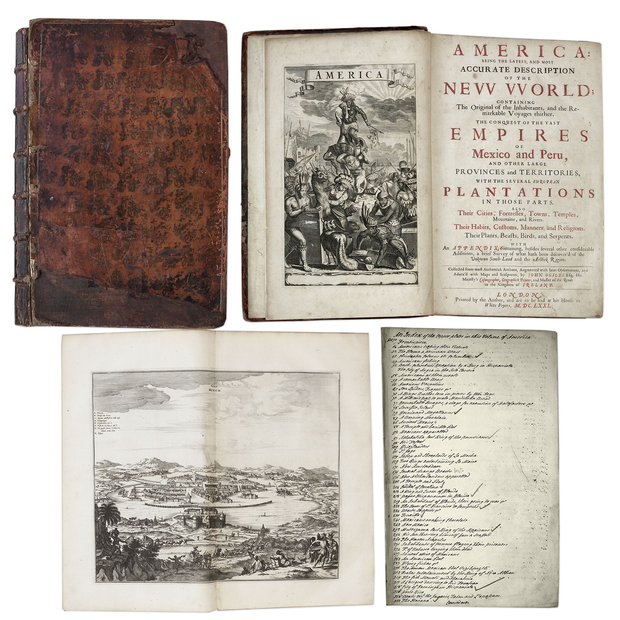
One of the most important books on the history of America (cited by Borba de Moraes, Howes, Sabin and Wing), the 1671 first edition of ”America: Being the Latest and Most Accurate Description of the New World”. Privately printed in London by the author, Arnoldus Montanus, and edited by John Ogilby. In ”America” Montanus goes into great detail of the new continents, with dozens of engravings of Native Americans, species of animals and reptiles, and the landscapes and settlements in the new world, accompanied by text. The book covers speculation regarding the earliest voyages to America, along with later recorded voyages and the settlements of New Netherlands/New York, New England, Hudson’s Bay, Labrador, Canada, Nova Scotia, Maryland, Virginia, (including Captain Smith’s capture and rescue by Pocahontas), Carolinas, Florida and California, plus accounts of Mexico and nearby islands, even including Australia and New Zealand. 674pp. book contains 75 original engravings (64 copper plates within the text and 9 plates throughout), lacking the maps and 28 engravings, which is typical as this edition is almost never found with all plates intact. All text is complete except for missing pages 445-446. Large format book measures 10” x 15”. Bound in original full leather boards, with some loss of leather to covers, cracking along spine and front board detached. Interior text is near fine and very readable. An important and fascinating addition to early knowledge of the American continent. Sold for $9,375.
Revolutionary War Map 1776
Revolutionary War map dated March 1776. “The Theatre of War in North America, With the Roads and a Table of the Distances…” Printed in London for R. Sayer and J. Bennett. Map depicts the area east of the Mississippi River from James Bay to Cape Canaveral, and locates provincial boundaries, towns, forts, roads, Indian villages, New England fishing waters, and the like. An inset is comprised of “Evan’s Polymetric Table of America,” which allows one to calculate the distance between most of the prominent towns. Text below the map reads, “A Compendious Account of the British Colonies in North America,” which devotes a paragraph of description to each of the North American colonies, including Florida, Canada, and the Province of Quebec. Issued separately by Sayer and Bennett, who also published “the American Military Pocket Atlas,” that year for the use of British officers. A notable map of the American Revolution, published the same year as the American Declaration of Independence. 20.75″ x 28.5″; 29.25″ x 37.5″ framed. Excellent condition. Sold for $6,000.

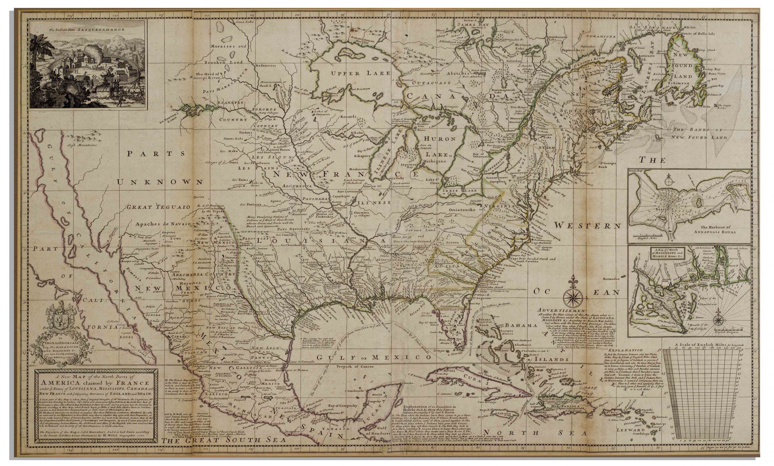
Herman Moll New Map of the North Parts of America
Large map of the Americas, published in 1720 by London cartographer Herman Moll entitled “A New Map of the North Parts of America claimed by France under ye names of Louisiana, Mississipi, Canada and New France with ye adjoyning territories of England and Spain”. Engraved map incorporates the latest surveying of the Americas, such as a French expedition into Texas in 1716. Map is hand-colored at boundaries, featuring a vignette at upper left of “The Indian Fort Sasquesahanok”, and with various “Explanations” of the map printed at bottom, including one of an Indian expedition into Florida, “6 days Rowing”. Insets of the Annapolis Harbor and the mouths of the Mississippi and Mobile Rivers are also included. Map is published in four vertical sections, laid down on archival paper and mounted on board. Map measures 25″ x 40.75″. Minor browning at section lines and a few spots of buckling. An attractive map in very good condition, giving historical insight into the jockeying for land among the major European powers in the early 18th century. Sold for $3,200.
FREE ESTIMATE. To buy, auction, sell or consign your Lewis Evans Geographical Printed by B Franklin 1756 that is for sale, please email your description and photos to [email protected] of Nate D. Sanders Auctions (http://www.NateDSanders.com).
Lewis Evans Geographical Printed by B Franklin 1756