Sell or Auction Your Admiranda Narratio Fida Tamen de Commodis 1590 for up to Over $30,000 or More at Nate D. Sanders Auctions
FREE APPRAISAL. To buy, auction, sell or consign your Admiranda Narratio Fida Tamen de Commodis 1590 that is for sale, please email your description and photos to [email protected] of Nate D. Sanders Auctions (http://www.NateDSanders.com).
Free Appraisal, Auction or Sell Your Admiranda Narratio Fida Tamen de Commodis 1590
Theodor de Bry (also Theodorus de Bry) (1528 – 27 March 1598) was an engraver, goldsmith, editor and publisher, famous for his depictions of early European expeditions to the Americas. The Spanish Inquisition forced de Bry, a Protestant, to flee his native, Spanish-controlled Southern Netherlands. He moved around Europe, starting from his birth on the city of Liège in the Prince-Bishopric of Liège, then to Strasbourg, Antwerp, London and Frankfurt, where he settled. De Bry created a large number of engraved illustrations for his books. Most of his books were based on first-hand observations by explorers, even if De Bry himself, acting as a recorder of information, never visited the Americas. To modern eyes, many of the illustrations seem formal but detailed.
Thomas Harriot (/ˈhæriət/; c. 1560 – 2 July 1621), also spelled Harriott, Hariot or Heriot, was an English astronomer, mathematician, ethnographer and translator to whom the theory of refraction is attributed. Thomas Harriot was also recognized for his contributions in navigational techniques, working closely with John White to create advanced maps for navigation. While Harriot worked extensively on numerous papers on the subjects of astronomy, mathematics and navigation, he remains obscure because he published little of it, namely only The Briefe and True Report of the New Found Land of Virginia (1588). This book includes descriptions of English settlements and financial issues in Virginia at the time. He is sometimes credited with the introduction of the potato to the British Isles. Harriot was the first person to make a drawing of the Moon through a telescope, on 26 July 1609, over four months before Galileo Galilei.
Below is a recent realized price for an Admiranda Narratio Fida Tamen de Commodis 1590 item. We at Nate D. Sanders Auctions can obtain up to this amount or more for you:
Admiranda Narratio Fida Tamen de Commodis 1590. Sold for Over $30,000.

click to enlarge
Nate D. Sanders Auctions has sold the following items:
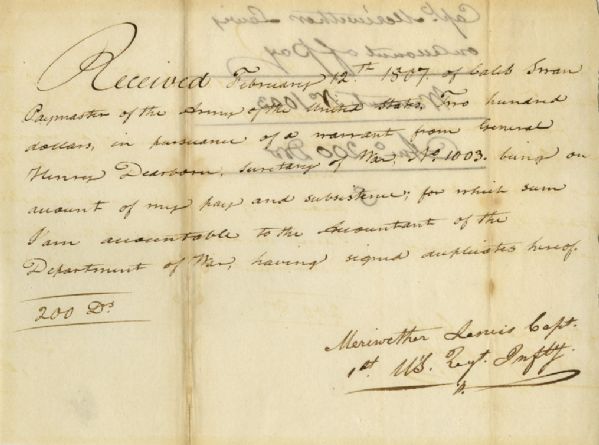
Very scarce Meriwether Lewis document signed ”Meriwether Lewis Capt. / 1st U’S. Regt. Infty.” Single octavo page, dated 12 February 1807 reads in full: ”Received February 12th 1807 of Caleb Swan Paymaster of the Army of the United States, Two hundred dollars, in pursuance of a warrant from General Henry Dearborn Secretary of War, No. 1003, being on account of my pay and subsistence, for which sum I am accountable to the Accountant of the Department of War, having signed duplicates hereof. 200 Drs.” In January 1803, President Thomas Jefferson sought to learn more about the far western territory, and appropriated the money from Congress for the proposed journey, to be led by the experienced explorer Meriwether Lewis. In his memoirs, Jefferson wrote of Lewis:
”Of courage undaunted; possessing a firmness and perseverance of purpose which nothing but impossibilities could divert from its direction; careful as a father of those committed to his charge, yet steady in the maintenance of order and discipline; intimate with the Indian characters, customs, and principles; habituated to the hunting life; guarded by exact observations of the vegetables and animals of his own country against losing time in the description of objects already possessed; honest, disinterested, liberal, of sound understanding, and a fidelity to truth so scrupulous that whatever he should report would be as certain as seen by ourselves…” (”History of the Expedition,” 1814). In the months immediately preceding the expedition, Lewis sought training in the use of astronomical instruments and in the art of map-making. He also chose a companion officer, William Clark of Louisville. While the expedition did not achieve the primary objective of finding the elusive Northwest Passage, it contributed significantly to the understanding of the geography of the Northwest and produced approximately 140 maps, the first accurate maps of the area. In addition, it documented 100 newly discovered species of animals, approximately 170 plants, and it also established friendly relations with three dozen Indian tribes. The knowledge they obtained sparked American interest in the west, and strengthened the nation’s claim to the area. Meriwether Lewis returned to Washington, D.C. from his three year journey in late December of 1806. After returning from the expedition, Lewis received a reward of 1,600 acres of land. In addition, Thomas Jefferson appointed him Governor of the Louisiana Territory. However, Lewis was not confirmed by the Senate until March 1807 and he remained a Captain in the interim. Base pay for Captains at this period was $40 per month so the present receipt would represent five months’ salary. A supremely rare document directly linking Meriwether Lewis to the Lewis & Clark Expedition. Items of Lewis & Clark related to the famed expedition are of the utmost rarity. Docketed on verso. Toning to folds and showthrough, otherwise near fine condition. Sold for $30,768.
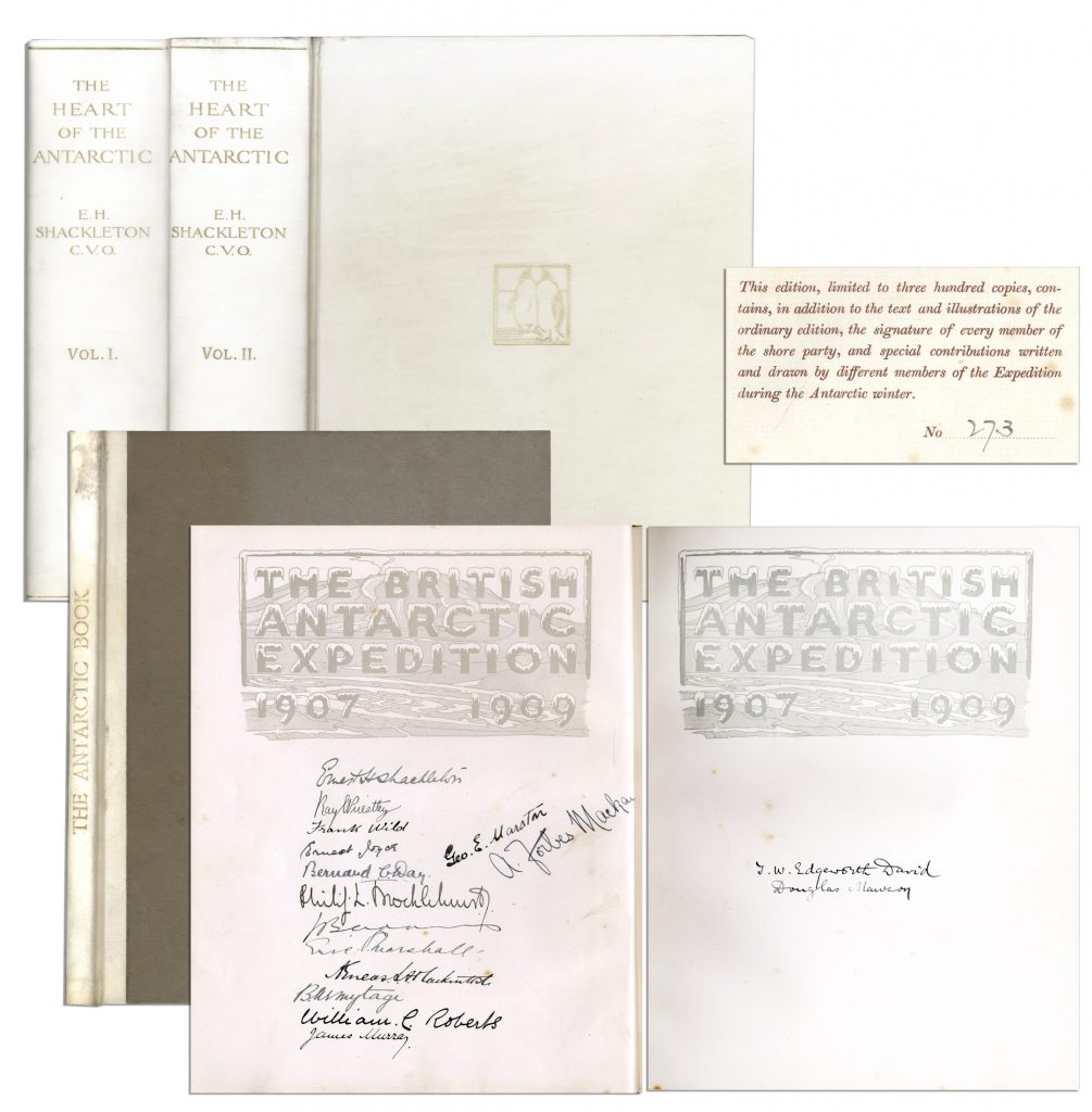
Ernest Shackleton & Crew Signed “The Heart of the Antarctic. Being the Story of the British Antarctic Expedition 1907-1909” Limited to Just 300 Copies, This Being All Three Volumes — Scarce
Ernest Shackleton’s signed copy of “The Heart of the Antarctic. Being the Story of the British Antarctic Expedition 1907-1909, 3 volumes (including “The Antarctic Book Winter Quarters 1907-09”), limited to 300 copies (here #273), also with signatures of the entire Shore party. Photogravure frontispiece, numerous plates (including 6 etched plates by George Marston, 16 tipped-in color after George Marston, others mostly photographic), one folding panorama and three folding lithographed maps in pocket at the end of volume three, illustrations and diagrams in the text. In publisher’s vellum, blocked in gilt with design of two penguins and top edges gilt. Occasional light spotting and small tear on cover of volume two. Overall in very good to near fine condition, signed by the Nimrod Shore Party crew. Sold for $12,718.
Beautiful and scarce Pilgrim document from 17th century colonial America. Dated 1670, document confirms the sale of 50 acres of land in Marshfield, Plymouth County, Massachusetts by John Rogers to William Macomber. Document is signed by a veritable who’s-who of Pilgrim notables, including Rogers, Nathaniel Morton, Constant Southworth and James Toale (Towle). In addition to writing the first historical text published in the United States (about the settlement of the Plymouth Colony) Nathaniel Morton was the first to publish a list of signers of the Mayflower Compact and also wrote his account of the first Thanksgiving. He served for most of his life as Secretary of Plymouth Colony, where his careful record-keeping enabled him to compile New England’s Memorial, considered the first comprehensive history of the colony, published at Cambridge in 1669, and widely considered the first book of history published in the United States. In fact, ”The Wall Street Journal” has published an excerpt from Morton’s history of Plymouth Colony as an op-ed the Wednesday before Thanksgiving Day since 1961. Constant Southworth came to Plymouth in 1628 as a teenager, and held several prominent positions during his life, including Treasurer of the Colony. John Rogers was born in 1642 in Plymouth County, the son of a Mayflower passenger. Document measures approximately 15.5” x 12” with some paper loss to lower right. Some expected foxing and toning, small amount of paper loss and archival tape repair to verso. In very good condition considering age, with still bold writing. Sold for $10,000.

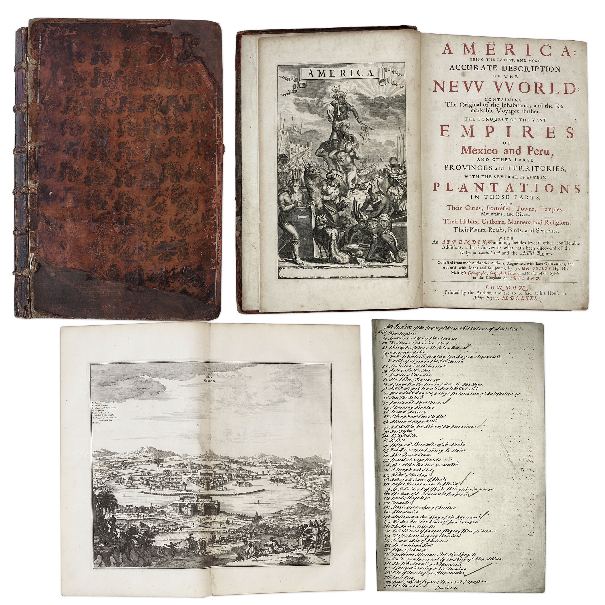
One of the most important books on the history of America (cited by Borba de Moraes, Howes, Sabin and Wing), the 1671 first edition of ”America: Being the Latest and Most Accurate Description of the New World”. Privately printed in London by the author, Arnoldus Montanus, and edited by John Ogilby. In ”America” Montanus goes into great detail of the new continents, with dozens of engravings of Native Americans, species of animals and reptiles, and the landscapes and settlements in the new world, accompanied by text. The book covers speculation regarding the earliest voyages to America, along with later recorded voyages and the settlements of New Netherlands/New York, New England, Hudson’s Bay, Labrador, Canada, Nova Scotia, Maryland, Virginia, (including Captain Smith’s capture and rescue by Pocahontas), Carolinas, Florida and California, plus accounts of Mexico and nearby islands, even including Australia and New Zealand. 674pp. book contains 75 original engravings (64 copper plates within the text and 9 plates throughout), lacking the maps and 28 engravings, which is typical as this edition is almost never found with all plates intact. All text is complete except for missing pages 445-446. Large format book measures 10” x 15”. Bound in original full leather boards, with some loss of leather to covers, cracking along spine and front board detached. Interior text is near fine and very readable. An important and fascinating addition to early knowledge of the American continent. Sold for $9,375.
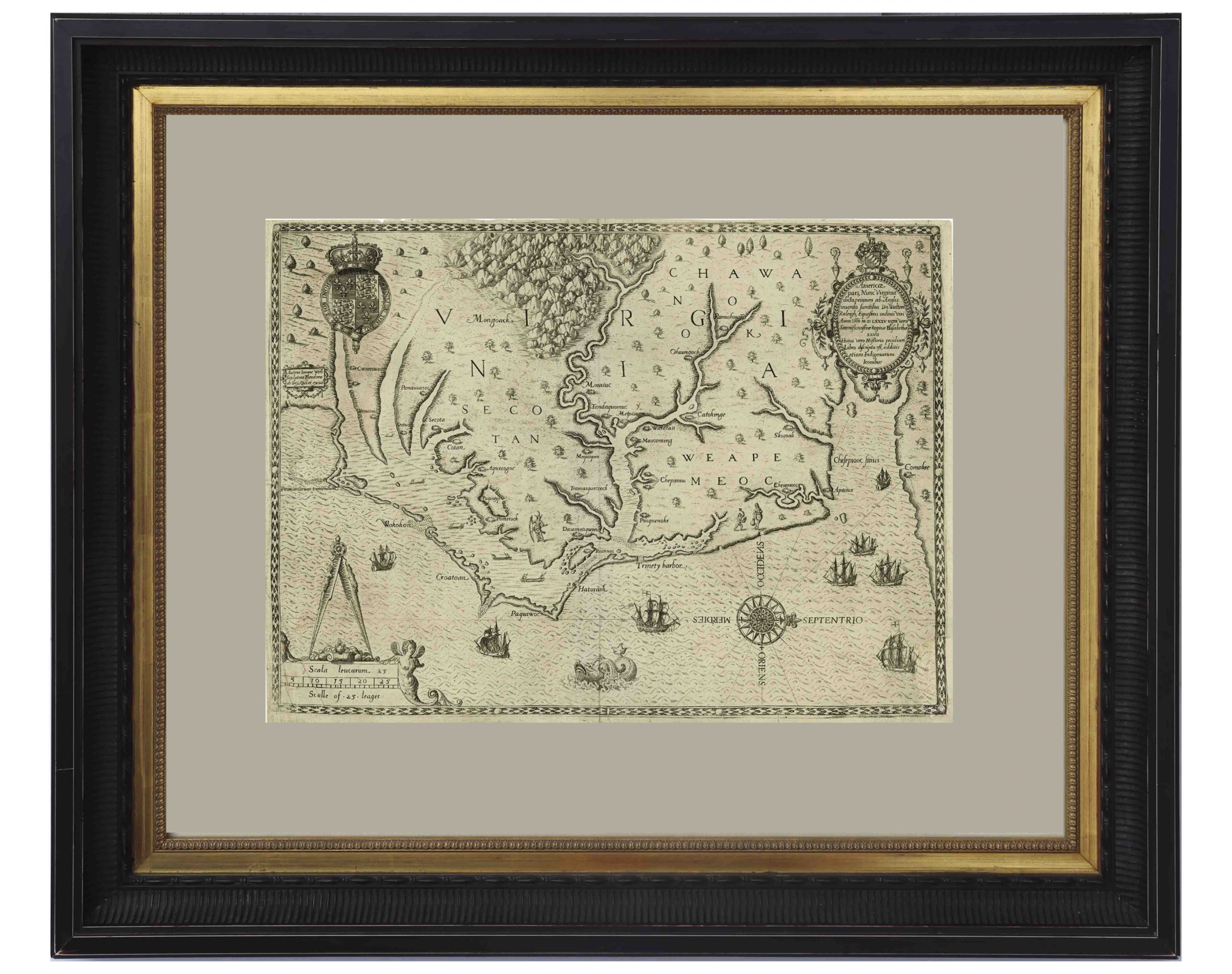
John White’s Map of Virginia From 1590 — The First Printed Map of Virginia and North Carolina
An important 16th century North American map known not only for its level of detail and accuracy, but also for its “firsts”: the first printed map of Virginia and North Carolina, the first to use Virginia in its title, the first to name the Chesapeake Bay, and also the first regional map showing the Roanoke Colony. Frankfurt: Theodor de Bry (engraver) for inclusion in his “Anglorum in Virginiam aduentus”, 1590.
Map is based on the work of cartographer, artist and explorer John White, one of the first settlers and Governor of the Roanoke Colony who, after sailing back to the Colony from England in 1587, had found all the colonists famously missing, their fate a mystery still unsolved. Philip Burden, who wrote the definitive reference book, “The Mapping of North America”, wrote of this map: “One of the most significant cartographical milestones in colonial North American history…the most accurate map drawn in the sixteenth century of any part of that continent.”
This full-sheet engraved map still retains its dark print, with the English Royal Arms at top left, and artistic touches throughout such as ships and sea monsters in the open ocean, and Native American canoeists in the inland waters. Map is the second state, with “C” laid over the “E” in Ehesepiooc. Map measures 16.675″ x 12.25″, nicely matted and framed to a size of 28″ x 23.5″. Expert repair to single vertical fold, and small area of repair to lower right corner, just touching the edge of the ship, where paper loss has been replaced. Overall in very good to near fine condition given age, displaying beautifully. Sold for $6,665.
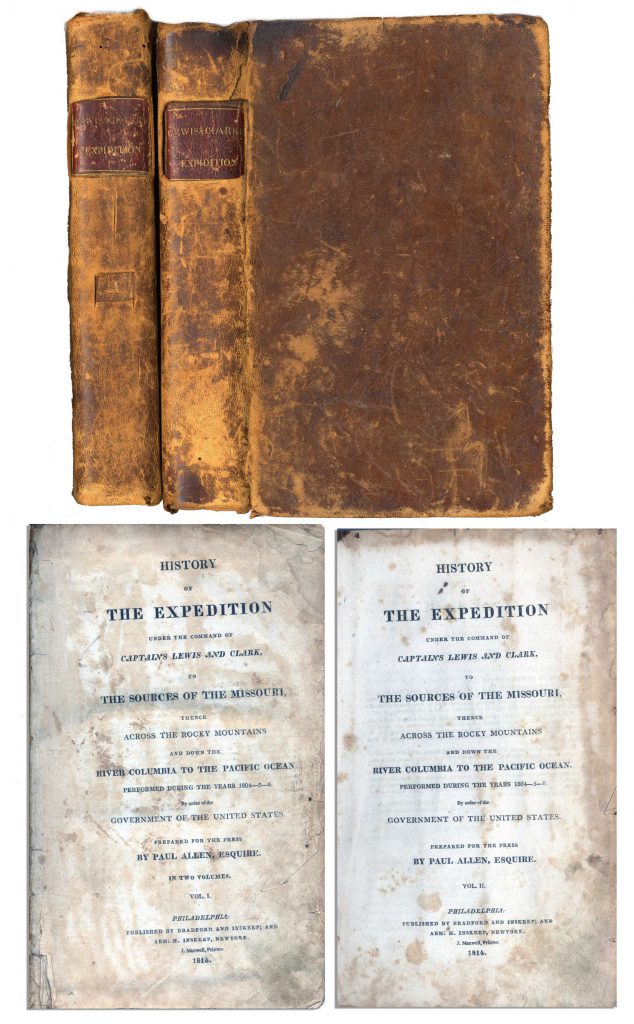
First edition, two-volume set of ”History of the Expedition under the Command of Captains Lewis and Clark to the source of the Missouri thence across the Rocky Mountains and down the river Columbia to the Pacific Ocean performed during the years 1804-05-06 by Meriwether Lewis and William Clark”. Published by Bradford and Inskeep: New York: 1814. Regarded as the definitive account of the first exhaustive, and most important Western exploration of America, which covered some eight thousand miles in slightly more than twenty-eight months. Lewis and Clark brought back the first reliable information about much of the area they traversed, made contact with the Native Americans as a prelude to the expansion of the fur trade, and advanced the geographical knowledge of the continent. This official account of the expedition is as much a landmark in Americana as the trip itself. Books, each measuring 5.5” x 8.75”, are bound in original marble-patterned leather boards and have five engraved, bound-in maps, missing the fold-out map found in some copies. Covers are worn and scuffed and the inside of covers have insect channels. Vol. I, 470pp., is missing the front free endpaper and has a chip out of the title page. Volume II runs 522pp. Light foxing and dampstaining throughout both volumes and some paper loss not affecting text. Overall in very good condition. An attractive set of America’s most important exploration narrative. Sold for $6,544.
Revolutionary War Map 1776
Revolutionary War map dated March 1776. “The Theatre of War in North America, With the Roads and a Table of the Distances…” Printed in London for R. Sayer and J. Bennett. Map depicts the area east of the Mississippi River from James Bay to Cape Canaveral, and locates provincial boundaries, towns, forts, roads, Indian villages, New England fishing waters, and the like. An inset is comprised of “Evan’s Polymetric Table of America,” which allows one to calculate the distance between most of the prominent towns. Text below the map reads, “A Compendious Account of the British Colonies in North America,” which devotes a paragraph of description to each of the North American colonies, including Florida, Canada, and the Province of Quebec. Issued separately by Sayer and Bennett, who also published “the American Military Pocket Atlas,” that year for the use of British officers. A notable map of the American Revolution, published the same year as the American Declaration of Independence. 20.75″ x 28.5″; 29.25″ x 37.5″ framed. Excellent condition. Sold for $6,000.

Lotter New and Correct Map of North America 1784
Large four-sheet engraved map measuring nearly 4′ x 3.5′ showing North America in 1784, with sovereignty of the thirteen colonies belonging to the United States following the Treaty of Paris that concluded the Revolutionary War. Published in Ausburg, Germany by Mathew Albert Lotter and Georg Frederic Lotter, 1784. Map is titled at upper right, “A new and correct map of North America with the West India Islands. Divided according to the last Treaty of Peace, concluded at Paris the 20th of Jan. 1783. wherein are particularly distinguished the Thirteen Provinces wich [sic] compose the United States of North America”. A cartouche underneath shows tradesmen and workers on the banks of Bermuda, and two insets show Baffin and Hudson’s Bay beneath the Arctic, and land bordering the “Sea of California” partially described as “The Passage by Land to California”. Map measures 46.875″ x 41″. Professionally backed to linen and lightly mounted to board. Minute foxing and a few spots of repair. Overall very good to near fine condition given age including superior color contrast. With fascinating detail, map would anchor a room and serve as an excellent topic of ongoing reflection and discussion. Sold for $1,750.

FREE APPRAISAL. To buy, auction, sell or consign your Admiranda Narratio Fida Tamen de Commodis 1590 that is for sale, please email your description and photos to [email protected] of Nate D. Sanders Auctions (http://www.NateDSanders.com).