Sell or Auction Your William Darby Memoir on The Geography of Florida 1821 1st Edition for Over $5,000 or More at Nate D. Sanders Auctions
FREE APPRAISAL. To buy, auction, sell or consign your William Darby Memoir on the Geography of Florida 1821 1st edition that is for sale, please email your description and photos to [email protected] of Nate D. Sanders Auctions (http://www.NateDSanders.com).
Sell Your William Darby Memoir on The Geography of Florida 1821 1st Edition
Below is a recent realized price for a William Darby Memoir on the Geography of Florida 1821 1st edition item. We at Nate D. Sanders Auctions can obtain up to these amounts or more for you:
William Darby Memoir on The Geography of Florida 1821 1st Edition. Sold for over $5,000.
Here are some recent items that our auction house, Nate D. Sanders (http://www.NateDSanders.com) has sold:
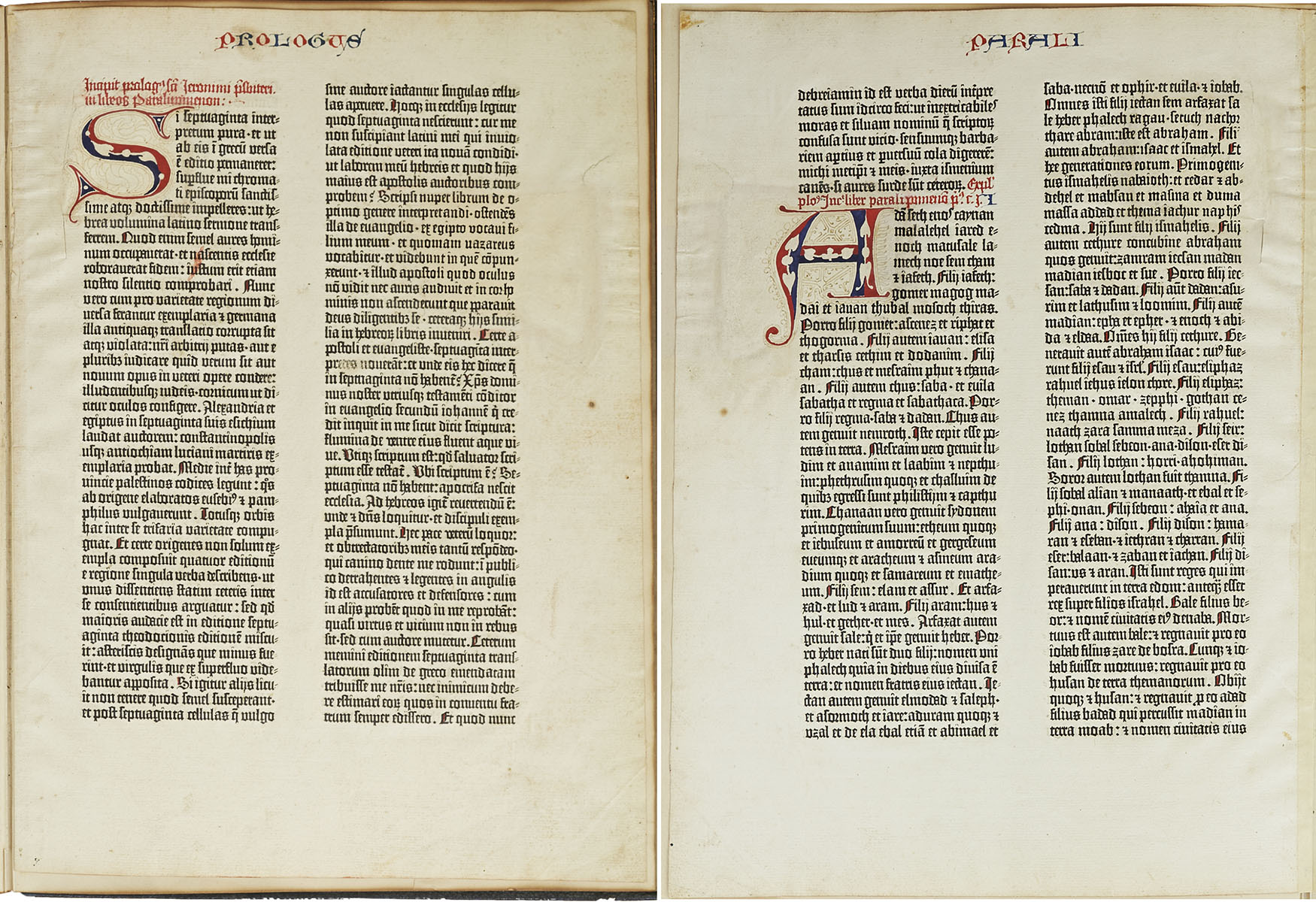
Gutenberg Bible Leaf 193 Chronicles of Old Testament
Scarce leaf from the Gutenberg Bible, one of the earliest major books printed from moveable metal type, the invention that ushered in the Age of Enlightenment by democratizing knowledge through mass production of literature. Printed by Johannes Gutenberg in Mainz, Germany from 1450-1455, less than 50 complete or near-complete copies of the Gutenberg Bible are now extant, with nearly all those housed in public institutions. Singular leaves are also scarce, with the leaf presented here having been acquired by bookseller Gabriel Wells, whose purchase of an incomplete Bible in 1920 gave way to selling the individual leaves alongside an essay by A. Edward Newton entitled “A Noble Fragment”. Leaf is number 193 of the full Latin Bible, with the recto being the Prologue to 1 Chronicles of the Old Testament, and the verso the first part of Chapter 1 of 1 Chronicles. Each page features two columns of 42 lines in dark black Gothic type, accented by red and blue rubrication. Each copy of the Gutenberg Bible differs in its rubrication and illumination, with buyers at the time deciding upon these embellishments after the Bible was printed. The six-line rubricated letters of this leaf were likely added later, restored to match the original style. Leaf measures 11.125″ x 15.375″, bound on edge to portfolio measuring 11.75″ x 16″. Paper quality is still bright with very little foxing or discoloration compared to other examples. A stunning example from the book that changed the course of history. Sold for $136,500.
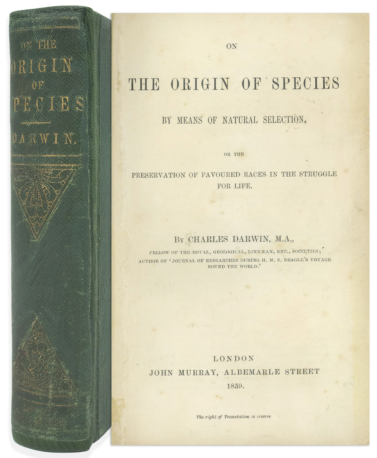
Charles Darwin On the Origin of Species 1st Edition
First edition, first printing of “On the Origin of Species” by Charles Darwin, one of the most important books in the scientific canon. London: John Murray, 1859. In this revolutionary book that upended man’s own view of himself, Darwin posits natural selection as the engine driving species’ evolution, an argument so persuasive that even 19th century religious leaders adjusted their teachings to allow for evolution to work in concert with divine planning. Its importance has only grown in the 150+ years since publication, with Freeman concluding it to be “the most important biological book ever written”. First released on 24 November 1859, its scarcity nearly matches its importance, with the first printing consisting of only 1,250 copies, and the number of extant copies now significantly fewer.
All first printing points are present, including original binding, variant B, title page with copyright information on verso, Table of Contents (pages v-ix) with binder instructions to verso, complete pages 1-502, and folding table present between pages 116-117. Bound in publisher’s full green boards, stamped and lettered in gilt. Overall in very good condition; ads at back of volume have been removed as has half-title page, and endpapers have been replaced. Volume is rebacked using morocco, with original spine laid down. Some shelf wear to boards. Light foxing throughout book, with some chipping, small closed tears with repairs to a few pages, and a few dogeared pages. One small mark on page 109, otherwise no internal writing or marks. Housed in a custom quarter-leather clamshell box. Overall in very good condition, a handsome, presentable copy of this scarce first printing. Sold for $68,250.
First edition of Sir Isaac Newton’s ”The Mathematical Principles of Natural Philosophy” in two volumes. London: Benjamin Motte, 1729. One of the most important works by the leading mind of the 18th century scientific revolution. Bound in contemporary tree calf, sympathetically rebacked, with gilt tooling to spines. Two octavo volumes measure 5.5” x 8.5” each. Volumes contain two folding letterpress tables and 47 folding engraved plates; the two frontispieces and pp. 385-393 and first 7pp. of index are replaced in facsimile, but hardly distinguishable from the original. The ”Laws of Moon’s Motion” usually found in Vol. II are here bound at end of Vol. I, and with errata for both volumes on verso of E4. Small stain to inner part of title in Vol. I, short tear to lower margin of G1, small section missing from lower margin of M3 and with lower corner cut away of A8 and C4 of ”Laws of Moon’s Motion” (no loss of text). Some marginal dampstaining and occasional soiling and spotting, overall in very good, clean condition with most edges untrimmed. Sold for $22,500.

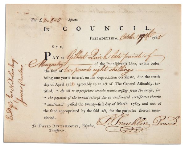
Benjamin Franklin 1785 Document Signed as President of Pennsylvania — Excellent, Bold Signature
Benjamin Franklin signs an interest certificate, dated 19 October 1785, one day after being elected President of Pennsylvania. Until May of that year he had served the new American nation as ambassador to France. Now, in a position similar to a modern day governor, Franklin authorizes Pennsylvania Treasurer David Rittenhouse to pay ”to Gilbert Quirk late private of Musquetry of the Pennsylvania Line, or his order, the sum of two pounds eight shillings being one year’s interest on his depreciation certificate, due the tenth day of April 1782 agreeably to an act of The General Assembly, intitled, ‘An act to appropriate certain monies arising from the excise, for the payment of the annual interest due on unalienated certificates therein mentioned,’ passed the twenty-first day of March 1783, and out of the fund appropriated by the said act, for the purposes therein mentioned.” He signs boldly, ”B. Franklin Presid.” with a paraph accentuating his name. The certificate, issued in Philadelphia, is endorsed on the verso: ”Received the within contents in full / For George Bickham / Sam Fulton”. Minor toning and foxing to 7.75” x 6.25” document, with tape repair to verso. Overall near fine condition. Sold for $15,436.
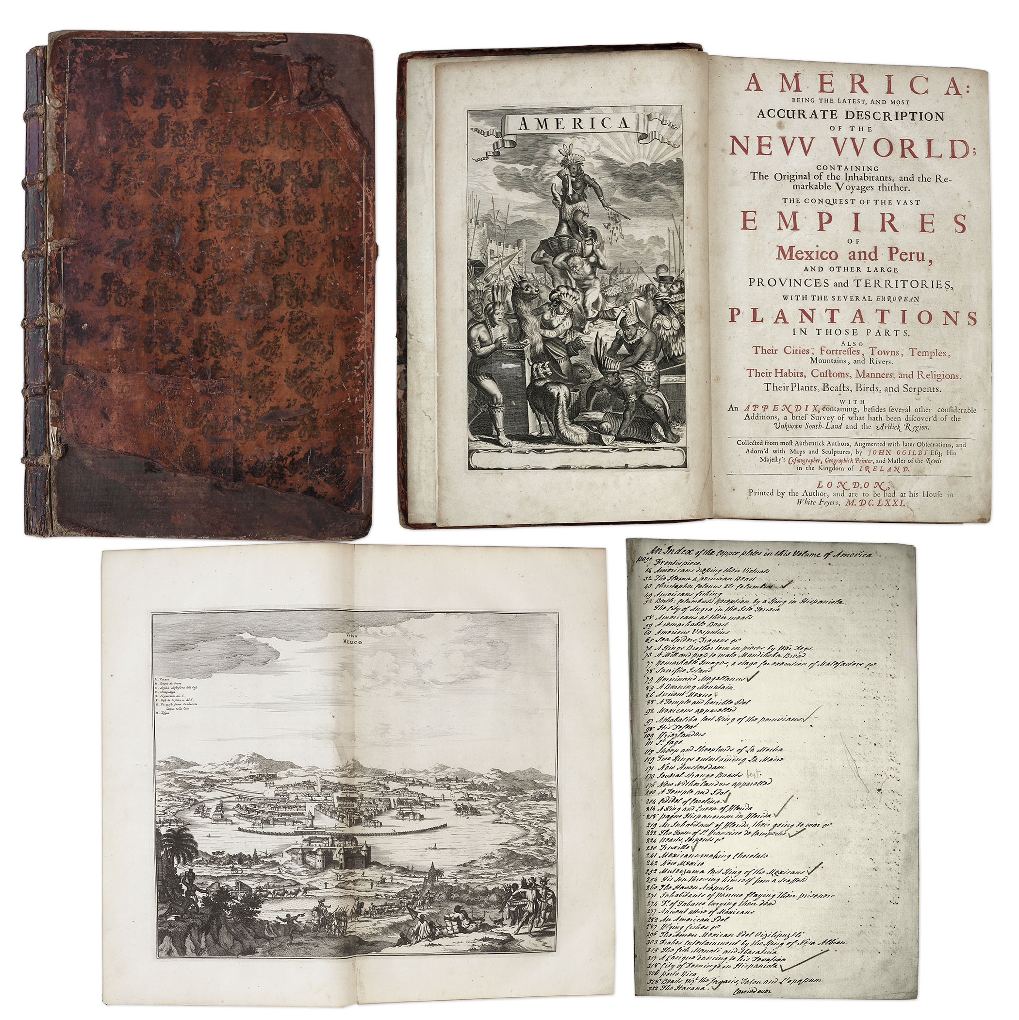
Important 17th Century First Edition of ”America: Being the Latest and Most Accurate Description of the New World” — Includes 75 Engravings of American Geography, Animals & Native People
One of the most important books on the history of America (cited by Borba de Moraes, Howes, Sabin and Wing), the 1671 first edition of ”America: Being the Latest and Most Accurate Description of the New World”. Privately printed in London by the author, Arnoldus Montanus, and edited by John Ogilby. In ”America” Montanus goes into great detail of the new continents, with dozens of engravings of Native Americans, species of animals and reptiles, and the landscapes and settlements in the new world, accompanied by text. The book covers speculation regarding the earliest voyages to America, along with later recorded voyages and the settlements of New Netherlands/New York, New England, Hudson’s Bay, Labrador, Canada, Nova Scotia, Maryland, Virginia, (including Captain Smith’s capture and rescue by Pocahontas), Carolinas, Florida and California, plus accounts of Mexico and nearby islands, even including Australia and New Zealand. 674pp. book contains 75 original engravings (64 copper plates within the text and 9 plates throughout), lacking the maps and 28 engravings, which is typical as this edition is almost never found with all plates intact. All text is complete except for missing pages 445-446. Large format book measures 10” x 15”. Bound in original full leather boards, with some loss of leather to covers, cracking along spine and front board detached. Interior text is near fine and very readable. An important and fascinating addition to early knowledge of the American continent. Sold for $9,375.
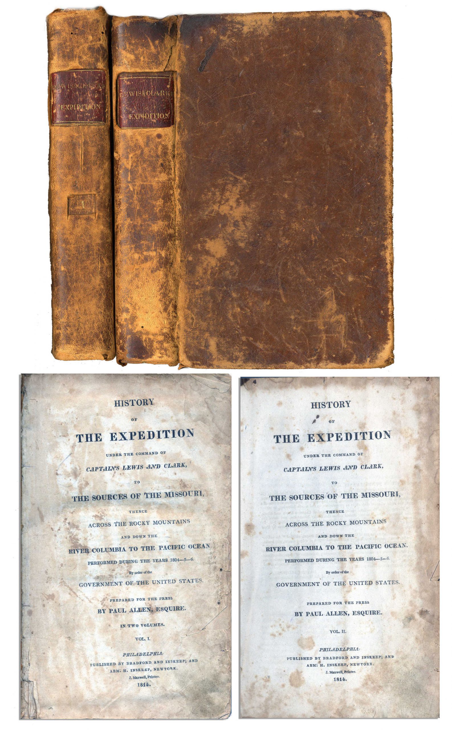
First edition, two-volume set of ”History of the Expedition under the Command of Captains Lewis and Clark to the source of the Missouri thence across the Rocky Mountains and down the river Columbia to the Pacific Ocean performed during the years 1804-05-06 by Meriwether Lewis and William Clark”. Published by Bradford and Inskeep: New York: 1814. Regarded as the definitive account of the first exhaustive, and most important Western exploration of America, which covered some eight thousand miles in slightly more than twenty-eight months. Lewis and Clark brought back the first reliable information about much of the area they traversed, made contact with the Native Americans as a prelude to the expansion of the fur trade, and advanced the geographical knowledge of the continent. This official account of the expedition is as much a landmark in Americana as the trip itself. Books, each measuring 5.5” x 8.75”, are bound in original marble-patterned leather boards and have five engraved, bound-in maps, missing the fold-out map found in some copies. Covers are worn and scuffed and the inside of covers have insect channels. Vol. I, 470pp., is missing the front free endpaper and has a chip out of the title page. Volume II runs 522pp. Light foxing and dampstaining throughout both volumes and some paper loss not affecting text. Overall in very good condition. An attractive set of America’s most important exploration narrative. Sold for $6,544.
Revolutionary War Map 1776
Revolutionary War map dated March 1776. “The Theatre of War in North America, With the Roads and a Table of the Distances…” Printed in London for R. Sayer and J. Bennett. Map depicts the area east of the Mississippi River from James Bay to Cape Canaveral, and locates provincial boundaries, towns, forts, roads, Indian villages, New England fishing waters, and the like. An inset is comprised of “Evan’s Polymetric Table of America,” which allows one to calculate the distance between most of the prominent towns. Text below the map reads, “A Compendious Account of the British Colonies in North America,” which devotes a paragraph of description to each of the North American colonies, including Florida, Canada, and the Province of Quebec. Issued separately by Sayer and Bennett, who also published “the American Military Pocket Atlas,” that year for the use of British officers. A notable map of the American Revolution, published the same year as the American Declaration of Independence. 20.75″ x 28.5″; 29.25″ x 37.5″ framed. Excellent condition. Sold for $6,000.

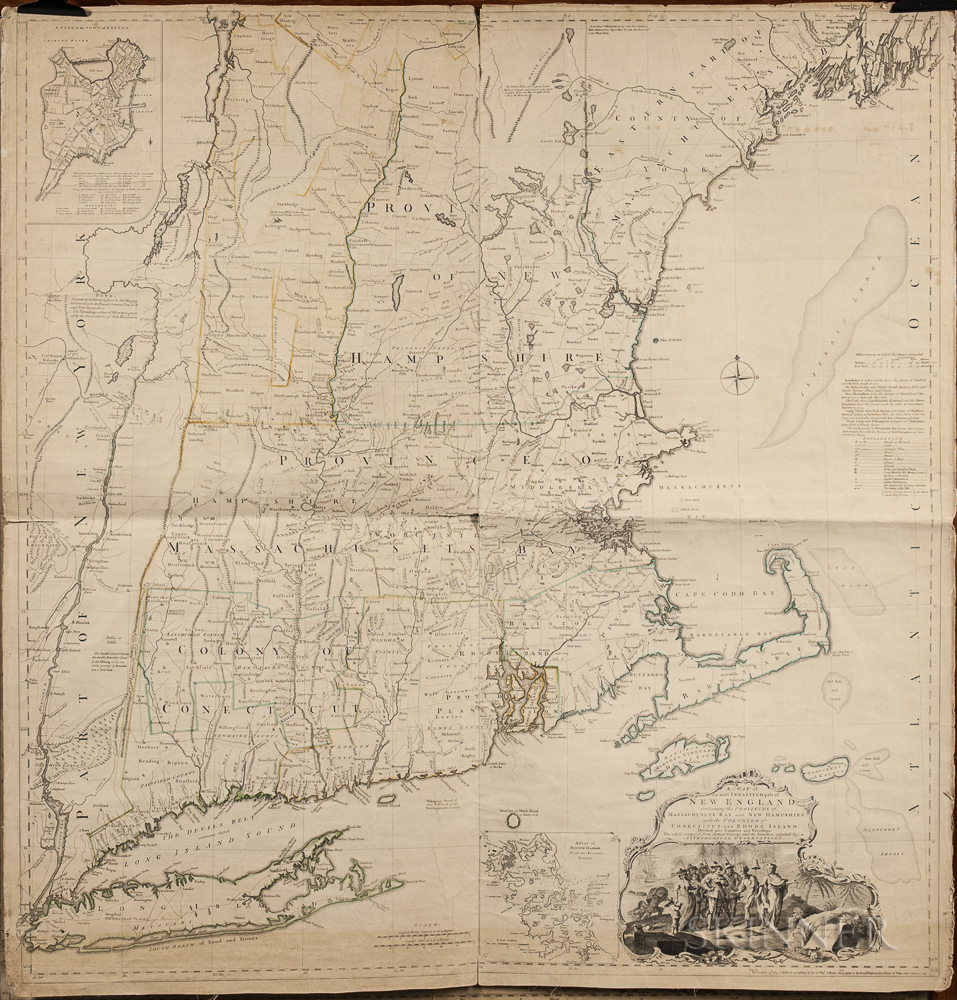
1774 Map of New England measuring over 40” square, the earliest large scale map of the New England colonies and used in the American Revolution. Drawn by Braddock Mead, and originally published in 1755, this copy was included in Thomas Jefferys’ ”American Atlas”, with hand-outlines. London: Printed and sold by R. Sayer and J. Bennett, 1776 (map dated 1774). Entitled in full, ”A Map of the Most Inhabited Part of New England Containing the Provinces of Massachusetts Bay and New Hampshire, with the Colonies of Connecticut and Rhode Island, Divided into Counties and Townships: The whole composed from Actual Surveys and its Situation adjusted by Astronomical Observations.” Measures 40” x 41.25”. Folded in fourths, as printed by copper-plate engraving on laid paper, mounted to linen. Light toning, chipping along margins and separation starting along folds. Overall in very good condition, a bright copy ideal for framing. Sold for $1,875.
Lotter New and Correct Map of North America 1784
Large four-sheet engraved map measuring nearly 4′ x 3.5′ showing North America in 1784, with sovereignty of the thirteen colonies belonging to the United States following the Treaty of Paris that concluded the Revolutionary War. Published in Ausburg, Germany by Mathew Albert Lotter and Georg Frederic Lotter, 1784. Map is titled at upper right, “A new and correct map of North America with the West India Islands. Divided according to the last Treaty of Peace, concluded at Paris the 20th of Jan. 1783. wherein are particularly distinguished the Thirteen Provinces wich [sic] compose the United States of North America”. A cartouche underneath shows tradesmen and workers on the banks of Bermuda, and two insets show Baffin and Hudson’s Bay beneath the Arctic, and land bordering the “Sea of California” partially described as “The Passage by Land to California”. Map measures 46.875″ x 41″. Professionally backed to linen and lightly mounted to board. Minute foxing and a few spots of repair. Overall very good to near fine condition given age including superior color contrast. With fascinating detail, map would anchor a room and serve as an excellent topic of ongoing reflection and discussion. Sold for $1,750.

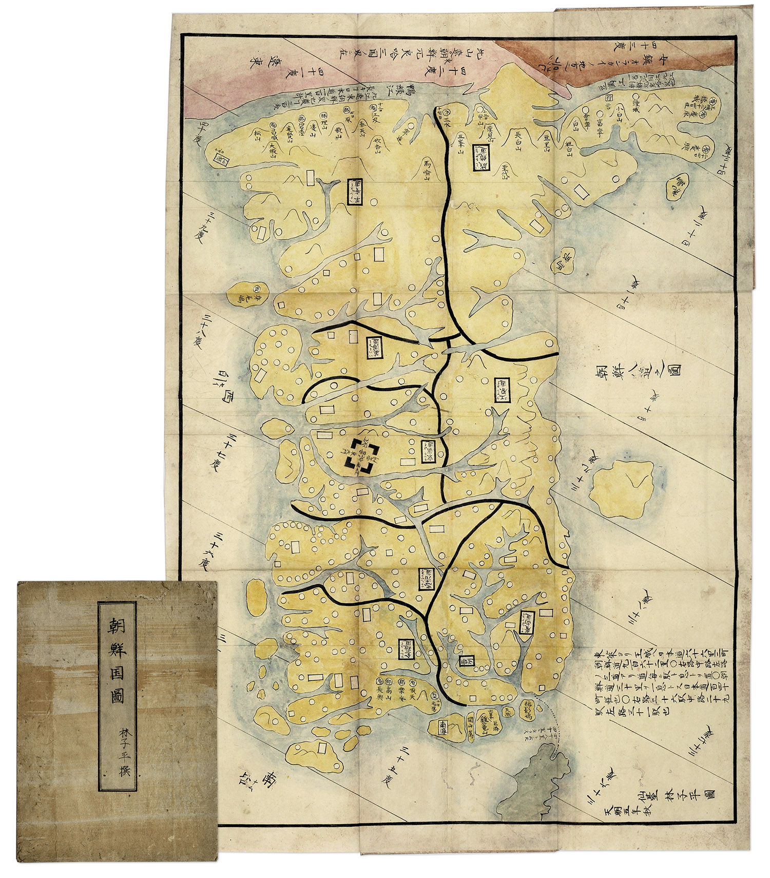
Hand-painted map of Korea by Hayashi Shihei, from Japan, circa 1785. Fold-out map shows the kingdoms outside Japan’s boundaries, but with the Kingdom of Joseon (Korea) being an important trading partner, the map was considered dangerous, and consequently banned by the Shogun in 1792. Has original cover boards and title slip. Measures 20” x 29” when folded out, and 7” x 9.5” when closed. Lightly toned and soiled, overall very good condition. Sold for $1,563.
Consign your William Darby Memoir on the Geography of Florida 1821 1st edition at Nate D. Sanders Auctions. Send a description of your ite and images of your item to us at [email protected].