Sell Your Parergon Sive Veteris Geographiae Aliquot Tabulae for up to $20,000 or More at Nate D. Sanders Auctions
FREE ESTIMATE. To buy, auction, sell or consign your Parergon sive Veteris Geographiae Aliquot Tabulae that is for sale, please email your description and photos to [email protected] of Nate D. Sanders Auctions (http://www.NateDSanders.com).
Sell Your Parergon sive Veteris Geographiae Aliquot Tabulae
Below is a recent realized price for a Parergon sive Veteris Geographiae Aliquot Tabulae item. We at Nate D. Sanders Auctions can obtain up to this amount or more for you:
Parergon sive Veteris Geographiae Aliquot Tabulae. Sold for Approximately $20,000.
Here are some items that our auction house, Nate D. Sanders (http://www.NateDSanders.com), has sold:
First edition of Sir Isaac Newton’s ”The Mathematical Principles of Natural Philosophy” in two volumes. London: Benjamin Motte, 1729. One of the most important works by the leading mind of the 18th century scientific revolution. Bound in contemporary tree calf, sympathetically rebacked, with gilt tooling to spines. Two octavo volumes measure 5.5” x 8.5” each. Volumes contain two folding letterpress tables and 47 folding engraved plates; the two frontispieces and pp. 385-393 and first 7pp. of index are replaced in facsimile, but hardly distinguishable from the original. The ”Laws of Moon’s Motion” usually found in Vol. II are here bound at end of Vol. I, and with errata for both volumes on verso of E4. Small stain to inner part of title in Vol. I, short tear to lower margin of G1, small section missing from lower margin of M3 and with lower corner cut away of A8 and C4 of ”Laws of Moon’s Motion” (no loss of text). Some marginal dampstaining and occasional soiling and spotting, overall in very good, clean condition with most edges untrimmed. Sold for $22,500.

Consign your Parergon sive Veteris Geographiae Aliquot Tabulae at Nate D. Sanders Auctions. Send a description of and images of your Parergon sive Veteris Geographiae Aliquot Tabulae to us at [email protected].
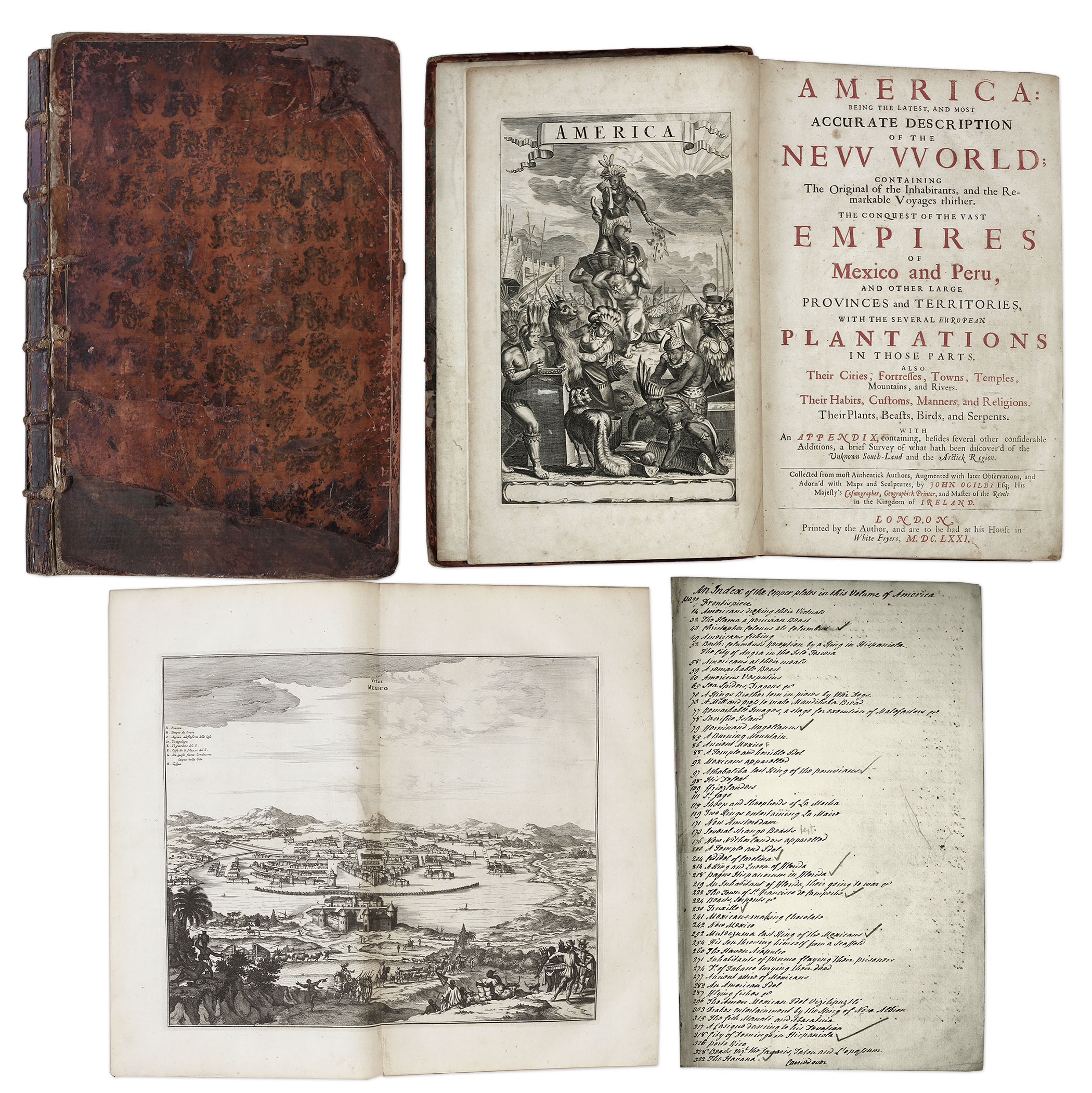
One of the most important books on the history of America (cited by Borba de Moraes, Howes, Sabin and Wing), the 1671 first edition of ”America: Being the Latest and Most Accurate Description of the New World”. Privately printed in London by the author, Arnoldus Montanus, and edited by John Ogilby. In ”America” Montanus goes into great detail of the new continents, with dozens of engravings of Native Americans, species of animals and reptiles, and the landscapes and settlements in the new world, accompanied by text. The book covers speculation regarding the earliest voyages to America, along with later recorded voyages and the settlements of New Netherlands/New York, New England, Hudson’s Bay, Labrador, Canada, Nova Scotia, Maryland, Virginia, (including Captain Smith’s capture and rescue by Pocahontas), Carolinas, Florida and California, plus accounts of Mexico and nearby islands, even including Australia and New Zealand. 674pp. book contains 75 original engravings (64 copper plates within the text and 9 plates throughout), lacking the maps and 28 engravings, which is typical as this edition is almost never found with all plates intact. All text is complete except for missing pages 445-446. Large format book measures 10” x 15”. Bound in original full leather boards, with some loss of leather to covers, cracking along spine and front board detached. Interior text is near fine and very readable. An important and fascinating addition to early knowledge of the American continent. Sold for $9,375.
Revolutionary War Map 1776
Revolutionary War map dated March 1776. “The Theatre of War in North America, With the Roads and a Table of the Distances…” Printed in London for R. Sayer and J. Bennett. Map depicts the area east of the Mississippi River from James Bay to Cape Canaveral, and locates provincial boundaries, towns, forts, roads, Indian villages, New England fishing waters, and the like. An inset is comprised of “Evan’s Polymetric Table of America,” which allows one to calculate the distance between most of the prominent towns. Text below the map reads, “A Compendious Account of the British Colonies in North America,” which devotes a paragraph of description to each of the North American colonies, including Florida, Canada, and the Province of Quebec. Issued separately by Sayer and Bennett, who also published “the American Military Pocket Atlas,” that year for the use of British officers. A notable map of the American Revolution, published the same year as the American Declaration of Independence. 20.75″ x 28.5″; 29.25″ x 37.5″ framed. Excellent condition. Sold for $6,000.

FREE ESTIMATE. To buy, auction, sell or consign your Parergon sive Veteris Geographiae Aliquot Tabulae that is for sale, please email your description and photos to [email protected] of Nate D. Sanders Auctions (http://www.NateDSanders.com). Top dollar obtained for your Parergon sive Veteris Geographiae Aliquot Tabulae.