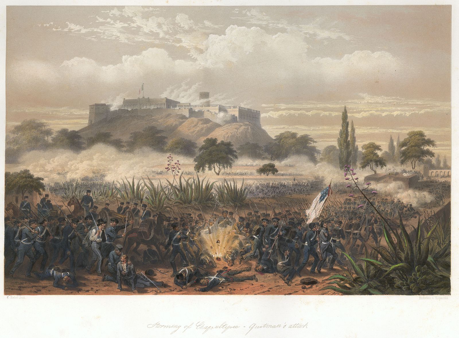
Sell or Auction Your George Wilkins Kendall United States Mexico 1851 for up to Over $20,000 or More at Nate D. Sanders Auctions
FREE APPRAISAL. To buy, auction, sell or consign your George Wilkins Kendall The War Between United States and Mexico 1851 that is for sale, please email your description and photos to [email protected] of Nate D. Sanders Auctions (http://www.NateDSanders.com).
Free Appraisal, Auction or Sell Your George Wilkins Kendall The War Between United States and Mexico 1851
Below is a recent realized price for a George Wilkins Kendall The War Between United States and Mexico (1851). We at Nate D. Sanders Auctions can obtain up to this amount or more for you:
George Wilkins Kendall The War Between United States and Mexico 1851. Sold for Over $20,000.
The following are some related items we have sold:
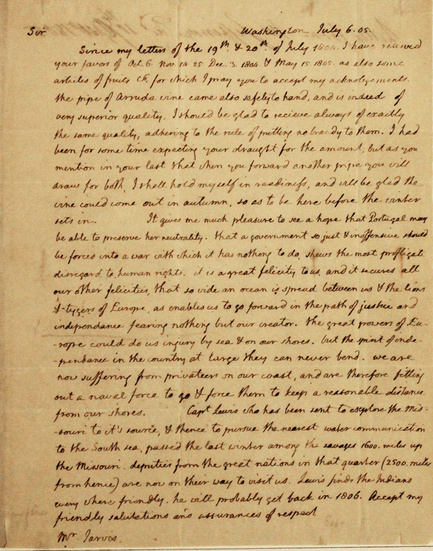
Thomas Jefferson Handwritten Report as President Regarding the Lewis & Clark Expedition
Exceptional, museum-worthy report, handwritten by Thomas Jefferson as President, regarding the Lewis and Clark Expedition. Letter is addressed to William Jarvis of the U.S. consul in Lisbon, Portugal, dated 6 July 1805, describing the historic expedition that Jefferson authorized during his Presidency. In its entirety: “Sir / Since my letters of the 19th & 20th of July 1804 I have received your favors of Oct. 6 Nov. 14-25 Dec. 3 1806 & May 15 1805. As also some articles of fruits & for which I may you accept my acknowledgments. The pipe of Arruda vine came also safely to hand, and is indeed of very superior quality. I should be glad to receive always of exactly the same quality, adhering to the rule of putting no brandy to them. I had been for some time expecting your draught [draft] for the amount; but as you mention in your last that when you forward another pipe you will draw for both, I shall hold myself in readiness, and will be glad the vine would come out in autumn, so as to be here before the winter sets in. It gives me much pleasure to see a hope that Portugal may be able to preserve her neutrality. That a government so just & inoffensive should be forced into a war with which it has nothing to do shows the most profligate disregard to human rights. It is a great felicity to us and it secures all our other felicities, that so wide an ocean is spread between us & the lions & tygers of Europe, as enables us to go forward in the path of justice and independence fearing nothing but our creator.
The great powers of Europe could do us injury by sea & on our shores. But the spirit of independence in the country at large they can never bend. We are now suffering from privateers on our coast, and are therefore fitting out a naval force to go & force them to keep a reasonable distance from our shores. Capt. Lewis who has been sent to explore the Missouri to its source & thence to pursue the nearest water communication to the South sea, passed the last winter among the savages 1600 miles up the Missouri. Deputies from the great nations in that quarter (2500 miles from hence) are now on their way to visit us. Lewis finds the Indians every where friendly. He will probably set back in 1806. Receipt my friendly salutations and assurances of respect.” Document measures 8″ x 10″ on two pages, with integral fly-leaf addressed to Jarvis in the hand of Jefferson’s secretary. Toning and folds throughout, with minor tape residue at top and a tiny chip at lower right corner. Near fine condition with bold, legible handwriting. An important piece of handwritten history by the President who commissioned America’s greatest exploration adventure. ADDITIONAL INFORMATION: A near exact copy of this letter resides in the Library of Congress’ Thomas Jefferson Papers. One of the two letters was produced by Jefferson’s polygraph machine (used from 1804 until his death), which provided an immediate copy of his handwritten letters. Though impossible to determine which copy was produced by the pen that Jefferson held, Jefferson typically kept the machine-produced letter as a copy for himself. Since this letter was mailed to William Jarvis (unlike the letter in the LOC), it’s probable that this letter was the one handwritten by Jefferson. It sold for $226,871.
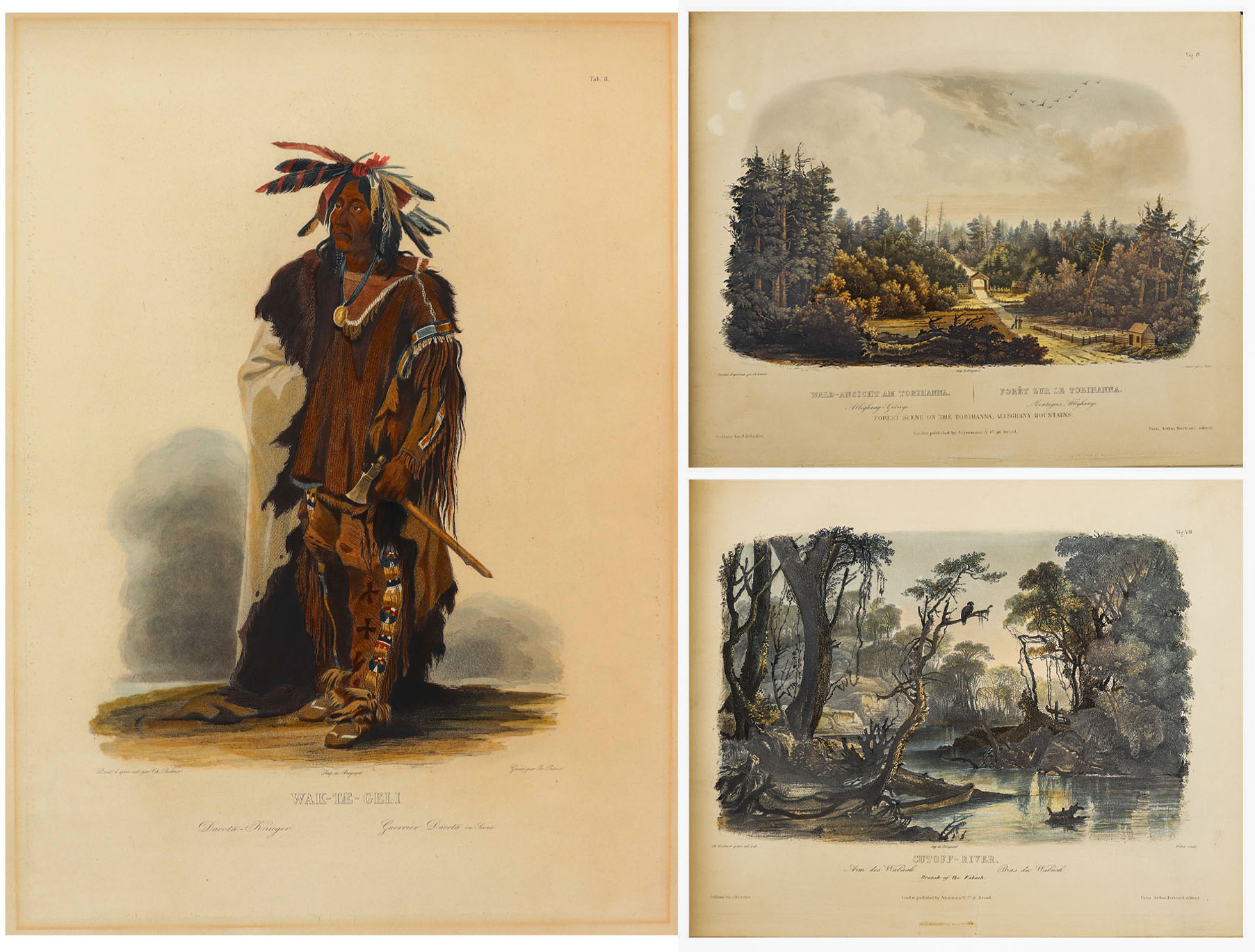
81 Beautiful Hand-Colored Aquatints by Karl Bodmer Depicting the American Frontier in the 1830s — Contained in the Illustrated Travelogue “Prince of Wied’s Travels in the Interior of North America”
Stunningly beautiful collection of 81 hand-colored aquatints by the Swiss artist Karl Bodmer, a complete collection from the illustrated travelogue, “Prince of Wied’s Travels in the Interior of North America”. Bodmer, who journeyed with the German Prince Maximilian of Wied-Neuwied from 1833-34 along the Missouri River, produced what is considered the best depictions of the indigenous peoples and landscapes during the frontier era, an America then still unspoiled by western migration. Of the Native American tribes of the Great Plains that they encountered, Bodmer’s depictions of the Blackfeet and Mandan tribes are especially important as the populations of these tribes were greatly affected by the smallpox epidemic of 1837, thus making Bodmer’s work the last visual testament to their culture.
Prince Max, as he was called, chose Bodmer to accompany him on the expedition along the Missouri River to visually depict the scenes that the Prince would write about. The result is this collection: three volumes of text by the Prince and two volumes of aquatints by Bodmer, in the first Paris edition published by Chez Arthus Bertrand, 1840-43 (“Voyage dans l’interieur de l’Amerique du Nord”). Text volumes in French also include 37 wood-engraved illustrations, only lacking the map in completeness. The two complete volumes of illustrations include the large folio volume with 48 oversized hand-colored aquatints measuring approximately 24.5″ x 18″, and the quarto volume with 33 hand-colored aquatints measuring approximately 12.5″ x 10.25″. The complete set of 81 aquatints is magnificent in their display, a time capsule with their hand-coloring evoking the sense of awe and discovery of the expedition. All volumes are bound in half black morocco and blue paper-covered boards with gilt accenting, and with black morocco labels to illustrated volumes. Minor handling wear to volumes, with a few small repaired tears to plates, some plates supplied with variance to margins, minute toning and foxing, a few plates beginning to separate from binding. Overall a very good plus set with excellent display quality. Sold for $175,000.


Scarce collection of 63 photographs from Carleton Watkins’ groundbreaking publication, ”Yosemite Valley: Photographic Views of the Falls and Valley of Yosemite in Mariposa County, California”. San Francisco, 1863. One of the most complete collections, lot comprises a total of 63 photographs, with two of the title page and map, and 61 of the Yosemite Valley, each measuring 11.625” x 7.5”. Scarce as such.
Lured out to California for the Gold Rush, Watkins soon turned his pursuits to photography, a calling for which he was naturally gifted. In 1861, he traveled to Yosemite outfitted with both mammoth-plate and stereoscopic cameras to make the first photographic narrative of the majestic valley, with these photographs the result. They were so impactful, after having been shared amongst Congressmen and Abraham Lincoln, that the Yosemite Grant Act was passed in 1864, a precursor to the creation of the U.S. National Park System in 1872.
Interestingly, no complete accounting of Watkins’ Yosemite photos from 1863 is documented, but next to a collection of 65 photographs, this grouping is the most complete at 63 photographs. Only a handful of other collections even claim more than 50 photographs. The views are exquisite, capturing the rock formations, foliage and natural water sources of the Valley as they appeared in 1861, yet unspoiled by overcrowding. Watkins’ ability to capture the depth of the images – with distant mountains hovering over meadows and streams, is particularly beautiful, aided by the use of his two camera systems.
Photographs retain superb contrast and tonality, all disbound in a period brown morocco gilt slipcase, tooled in gilt on the cover, ”Watkins’ Yosemite Gallery.” Overall in very good to near fine condition. Sold for $112,500.

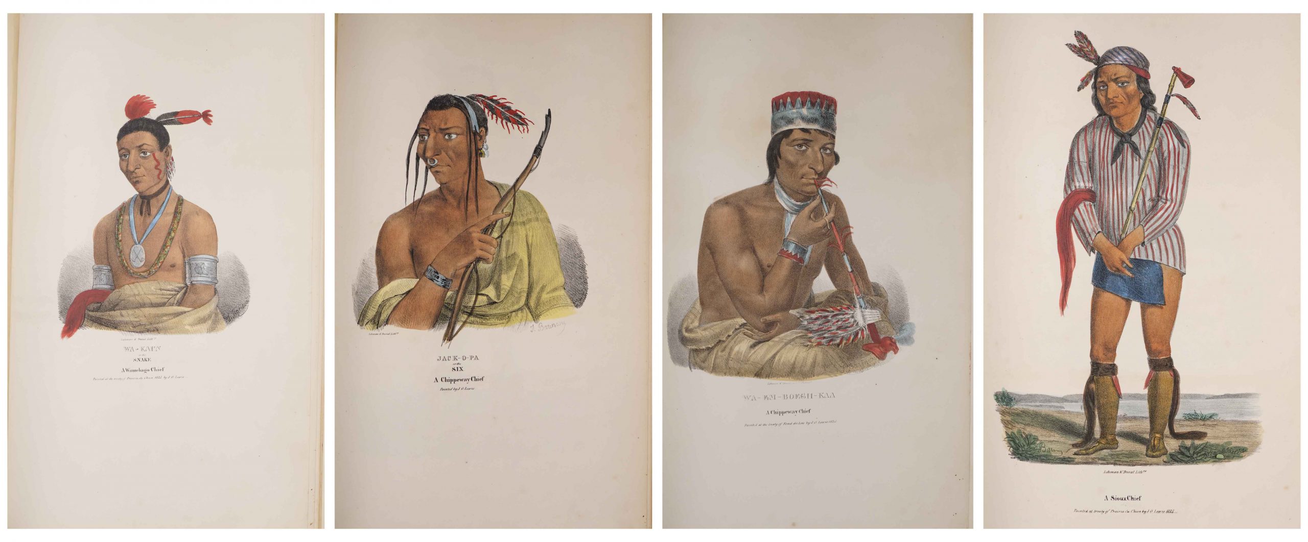
Complete Set of 80 Hand-Colored Lithographs of “The Aboriginal Port Folio” by James Otto Lewis From 1835-1838 — Extremely Scarce Complete Set
Very scarce complete set of the “Aboriginal Port Folio”, containing 80 hand-colored lithographs by Native American visual chronicler James Otto Lewis, whose travels to various treaty ceremonies during the early 19th century produced lasting portraits of Native American leaders and customs. Lewis was the first to create such artwork, preceding McKenney & Hall by several years. Philadelphia: George Lehman and Peter S. Duvall, 1835-1838.
After painting portraits of members from the Sioux, Potawatomi, Winnebago, Fox, Shawnee, Miami, and Iowa tribes, Lewis brought his paintings to Philadelphia for lithography, releasing them by subscription in 10 installments of 8 lithographs apiece. Each installment grew more scarce as subscriptions trailed off with the impending publication of the more comprehensive (and more formally posed) “History of the Indian Tribes of North America” by McKenney & Hall, whose portrait artist Charles Bird King even copied some of Lewis’ paintings. As a result, the full collection of 80 lithographs of “The Aboriginal Port Folio” is so scarce that only five to ten copies are known to exist. To make matters worse, Lewis’ original paintings were destroyed in the Smithsonian fire in 1865.
This set is in very good to near fine condition, with only minor scattered foxing affecting some sheets. In addition to the 80 pictorial lithographs, set also includes the lithograph title page and three leaves of advertisements, making it a truly complete set. Lithographs each measure 11.5″ x 18.125″, housed in three-quarter red morocco clamshell case with custom lettering to spine. One of the few visual remembrances of this important collection preserved for history. Sold for $84,000.

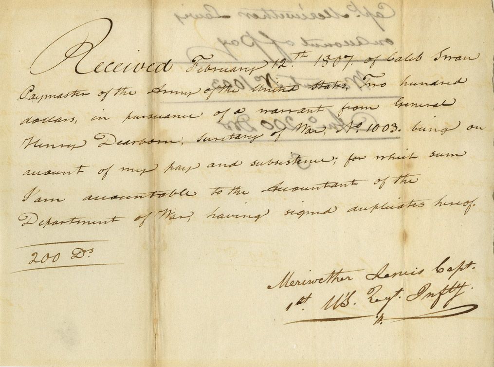
Meriwether Lewis 1807 Document Signed Related to the Famed Lewis & Clark Expedition — Lewis Receives 5 Months Pay From the Expedition Upon Returning to D.C.
Very scarce Meriwether Lewis document signed ”Meriwether Lewis Capt. / 1st U’S. Regt. Infty.” Single octavo page, dated 12 February 1807 reads in full: ”Received February 12th 1807 of Caleb Swan Paymaster of the Army of the United States, Two hundred dollars, in pursuance of a warrant from General Henry Dearborn Secretary of War, No. 1003, being on account of my pay and subsistence, for which sum I am accountable to the Accountant of the Department of War, having signed duplicates hereof. 200 Drs.” In January 1803, President Thomas Jefferson sought to learn more about the far western territory, and appropriated the money from Congress for the proposed journey, to be led by the experienced explorer Meriwether Lewis. In his memoirs, Jefferson wrote of Lewis: ”Of courage undaunted; possessing a firmness and perseverance of purpose which nothing but impossibilities could divert from its direction; careful as a father of those committed to his charge, yet steady in the maintenance of order and discipline; intimate with the Indian characters, customs, and principles; habituated to the hunting life; guarded by exact observations of the vegetables and animals of his own country against losing time in the description of objects already possessed; honest, disinterested, liberal, of sound understanding, and a fidelity to truth so scrupulous that whatever he should report would be as certain as seen by ourselves…” (”History of the Expedition,” 1814). In the months immediately preceding the expedition, Lewis sought training in the use of astronomical instruments and in the art of map-making. He also chose a companion officer, William Clark of Louisville. While the expedition did not achieve the primary objective of finding the elusive Northwest Passage, it contributed significantly to the understanding of the geography of the Northwest and produced approximately 140 maps, the first accurate maps of the area. In addition, it documented 100 newly discovered species of animals, approximately 170 plants, and it also established friendly relations with three dozen Indian tribes. The knowledge they obtained sparked American interest in the west, and strengthened the nation’s claim to the area. Meriwether Lewis returned to Washington, D.C. from his three year journey in late December of 1806. After returning from the expedition, Lewis received a reward of 1,600 acres of land. In addition, Thomas Jefferson appointed him Governor of the Louisiana Territory. However, Lewis was not confirmed by the Senate until March 1807 and he remained a Captain in the interim. Base pay for Captains at this period was $40 per month so the present receipt would represent five months’ salary. A supremely rare document directly linking Meriwether Lewis to the Lewis & Clark Expedition. Items of Lewis & Clark related to the famed expedition are of the utmost rarity. Docketed on verso. Toning to folds and showthrough, otherwise near fine condition. Sold for $30,768.
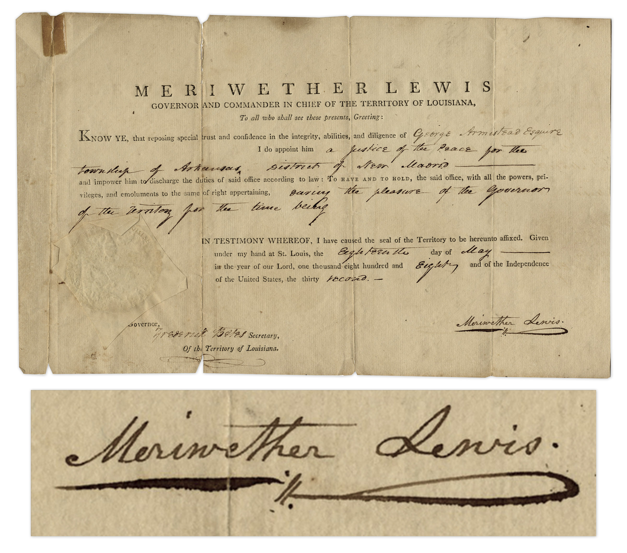
Meriwether Lewis Signed Appointment as Governor of Louisiana From 1808 — Very Scarce Signature, Dated 2 Years After the Lewis & Clark Expedition
As Governor and Commander in Chief of Louisiana, Meriwether Lewis signs his full name in black ink to a document, appointing George Armistead to the position of ”Justice of the Peace for the township of Arkansas, District of New Madrid” on 18 May 1808. Armistead would later become the Commander of American forces during the bombardment of Fort McHenry in the War of 1812. Lewis’ signature is very scarce as he died of a gunshot wound in 1809, with few documents signed by him as Governor of Louisiana during his 2-year tenure. Document is also one of the few after his expedition from 1804-1806 with William Clark, which charted the newly acquired Louisiana Territory for the United States, a highly dangerous mission but successful mission. Document retains its paper-covered seal and is co-signed by Secretary Frederick Bates, who later became Governor of Missouri. A great Lewis and Clark autograph. Measures 12.5” x 7.75”. Document has been archivally repaired at left panel, small tears at edges of folds, tape to top of left panel, overall very good condition. Sold for $24,513.
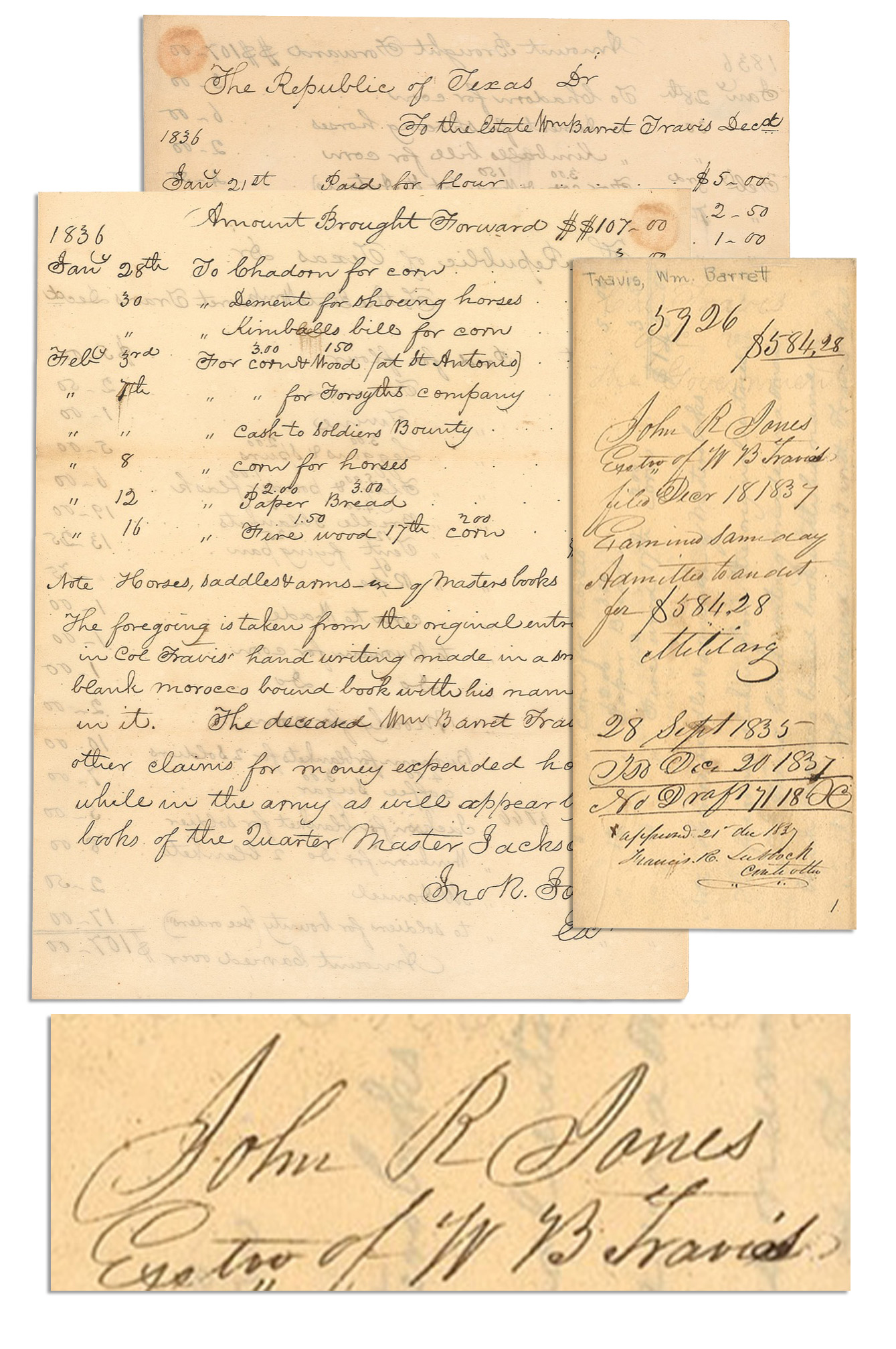
Receipt with itemized expenses incurred by Lt. Col. William Barret Travis for provisions he bought to arm and feed his Alamo soldiers. Receipt is signed by General John R. Jones, executor of Travis’ estate, listing 27 items for a total of $143 that Travis bought from January through March 1836, while under assault from the Mexican Army. It was in February 1836 that Travis wrote to his fellow Texans: ”I am besieged, by a thousand or more of the Mexicans under Santa Anna…The enemy is receiving reinforcements daily…I shall never surrender or retreat.” Addressed to the Republic of Texas, document reads: ”…the Estate Wm Barret Travis…1836 Jany 21st Paid for flour $5.00 / Tin ware 2.50 / Twine 1.00 / Leggins 3.00 & Spurs 2.00 / Flag 5.00 & Powder Flask 1.00…” continuing, ”…The foregoing is taken from the original entries in Col. Travis’ handwriting made in a small black morocco bound book with his name in it. The deceased Wm. Barret Travis has other claims for money expended horses &c while in the army as will appear by the books of the Quarter Master Jackson…” Jones notes the document was, ”…filed Dec. 18, 1837.” An endorsement by Francis Lubbock reads, ”Approved 21st Dec 1837, Francis R. Lubbock, Controller.” 2pp. document on a single sheet, measures 7.75” x 9.75”. Toning, circular stain to upper left corner and light show-through from writing on opposite side, else near fine condition. An incredible document honoring the heroism and self-sacrifice of the Alamo commander. Sold for $20,133.
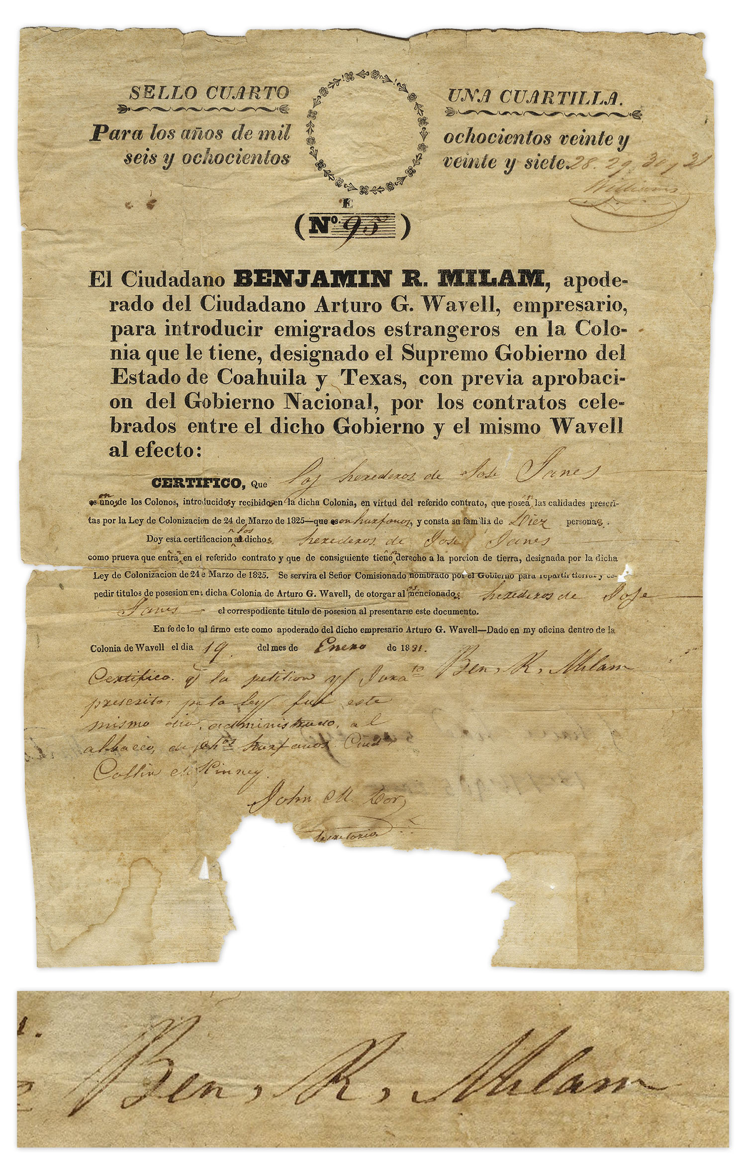
Likely the only surviving manuscript of its kind, document signed by Benjamin Milam, granting citizenship into Milam’s Red River Colony. Dated 19 January 1831, Milam signs this document nearly five years before he would be killed in the Siege of Bexar during the Texas Revolution, as he called to his fellow compatriots: ”Who will go with old Ben Milam into San Antonio?”
Founded by Milam and Arturo G. Wavell in 1826, the Red River Colony was an effort by the men to settle land in present-day northeast Texas along the Red River under the Colonization Law of March 24, 1825. The Mexican law was passed to encourage Texas settlement by offering 4,000 acres of land for farming and ranching with the caveats that the colonists abide by Mexican law, worship as Catholics, and demonstrate good moral conduct. Milam and Wavell applied for a land grant from the vice governor of Coahuila y Texas, who approved the request in 1826, giving the entrepreneurs six years to form the Colony. Partially-printed document ”No. 95” lists Milam and Wavell’s names in print, translated in part, ”…For the years one thousand eight hundred twenty-six and eight hundred twenty-seven [handwritten numbers of 28, 29, 30, 31 added]…The Citizen Benjamin R. Milam, agent for the Citizen Arturo G. Wavell, businessman, introduce foreign emigrants into the Colony…I certify that he and heirs of Jose Janes[?] are one of the settlers, introduced into the said colony, by virtue of said contract, possessing the qualities prescribed by the Colonization Law of March 24, 1825 – which are and consist of his family of Ten people. I hereby certify the said heirs of Jose Janes as proof that he enters into said contract and that he is therefore entitled to the portion of land designated by said Colonization Act of March 24, 1825…in said Colony of Arturo G. Wavell…I sign this as proxy of the said businessman Arturo G. Wavell – Given in my office inside the Colony of Wavell on the 19th, of the month of January, 1831…” Signed ”Ben. R. Milam”.
Single page Benjamin Milam autograph document measures 8.25” x 11.25”. Paper loss at bottom of document approximately 3” x 1.25, light wear and toning. Mounting remnants and archival tape repair to verso of Benjamin Milam autograph document. Overall the Benjamin Milam autograph document is in good to very good condition. One of less than a handful of documents signed by Milam known to exist, and the only known document granting citizenship in his Red River Colony. Sold for $12,000.
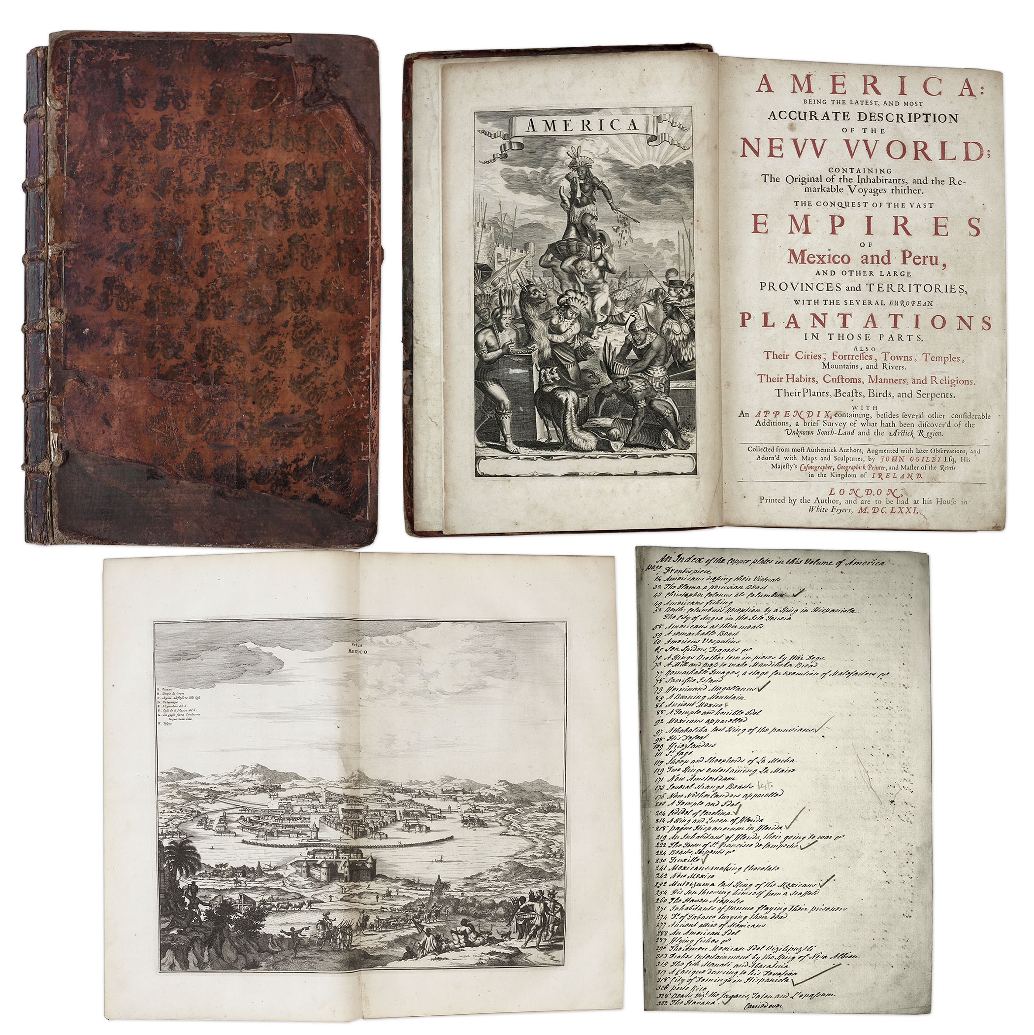
One of the most important books on the history of America (cited by Borba de Moraes, Howes, Sabin and Wing), the 1671 first edition of ”America: Being the Latest and Most Accurate Description of the New World”. Privately printed in London by the author, Arnoldus Montanus, and edited by John Ogilby. In ”America” Montanus goes into great detail of the new continents, with dozens of engravings of Native Americans, species of animals and reptiles, and the landscapes and settlements in the new world, accompanied by text. The book covers speculation regarding the earliest voyages to America, along with later recorded voyages and the settlements of New Netherlands/New York, New England, Hudson’s Bay, Labrador, Canada, Nova Scotia, Maryland, Virginia, (including Captain Smith’s capture and rescue by Pocahontas), Carolinas, Florida and California, plus accounts of Mexico and nearby islands, even including Australia and New Zealand. 674pp. book contains 75 original engravings (64 copper plates within the text and 9 plates throughout), lacking the maps and 28 engravings, which is typical as this edition is almost never found with all plates intact. All text is complete except for missing pages 445-446. Large format book measures 10” x 15”. Bound in original full leather boards, with some loss of leather to covers, cracking along spine and front board detached. Interior text is near fine and very readable. An important and fascinating addition to early knowledge of the American continent. Sold for $9,375.
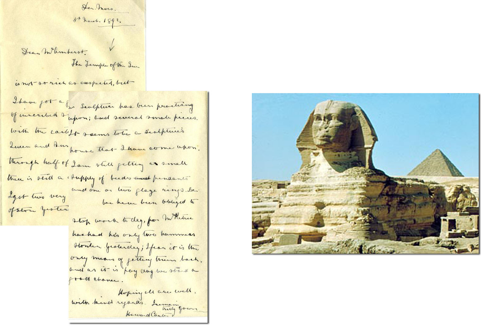
Howard Carter ALS 1892
Autograph letter signed from English archaeologist and Egyptologist, noted as a primary discoverer of the tomb of Tutankhamun, Howard Carter. Datelined “Deri Moes / 5th March 1892,” Carter writes to his mentor, Lord Amherst, during his early excavations at the Temple of the Sun. Letter reads in full, “The Temple of the Sun is not so rich as expected, but I have a good many blocks of inscribed stone from it, with the cartouges [sic] often King and queen and Sun. I have only got through half of it as yet so that there is still a chance of good luck. I got two very interesting blocks of stone yesterday, on which a sculpture has been practicing upon; had several small pieces. It seems to be a sculpture’s house that I have come upon. I am still getting a small supply of beds [sic] pendants and one or two glaze rings &c: We have been obliged to stop work today, for Mr. Petrie has had his only two hammers stolen yesterday; I fear it is the only means of getting them back, and as it is pay day we stand a good chance. Hoping all are well, with kind regards. I remain, Truly yours / Howard Carter.” On 16 February 1923, at 4pm Carter opened the burial chamber and first saw the sarcophagus of Tutankhamun. It was the sensation of the 20th Century. Tutankhamun mania swept the world and Carter was immortalized. This lot gives a fascinating insight into Carter’s early travails. Near fine condition. Accompanied by COA from PSA/DNA. Sold for $9,000.
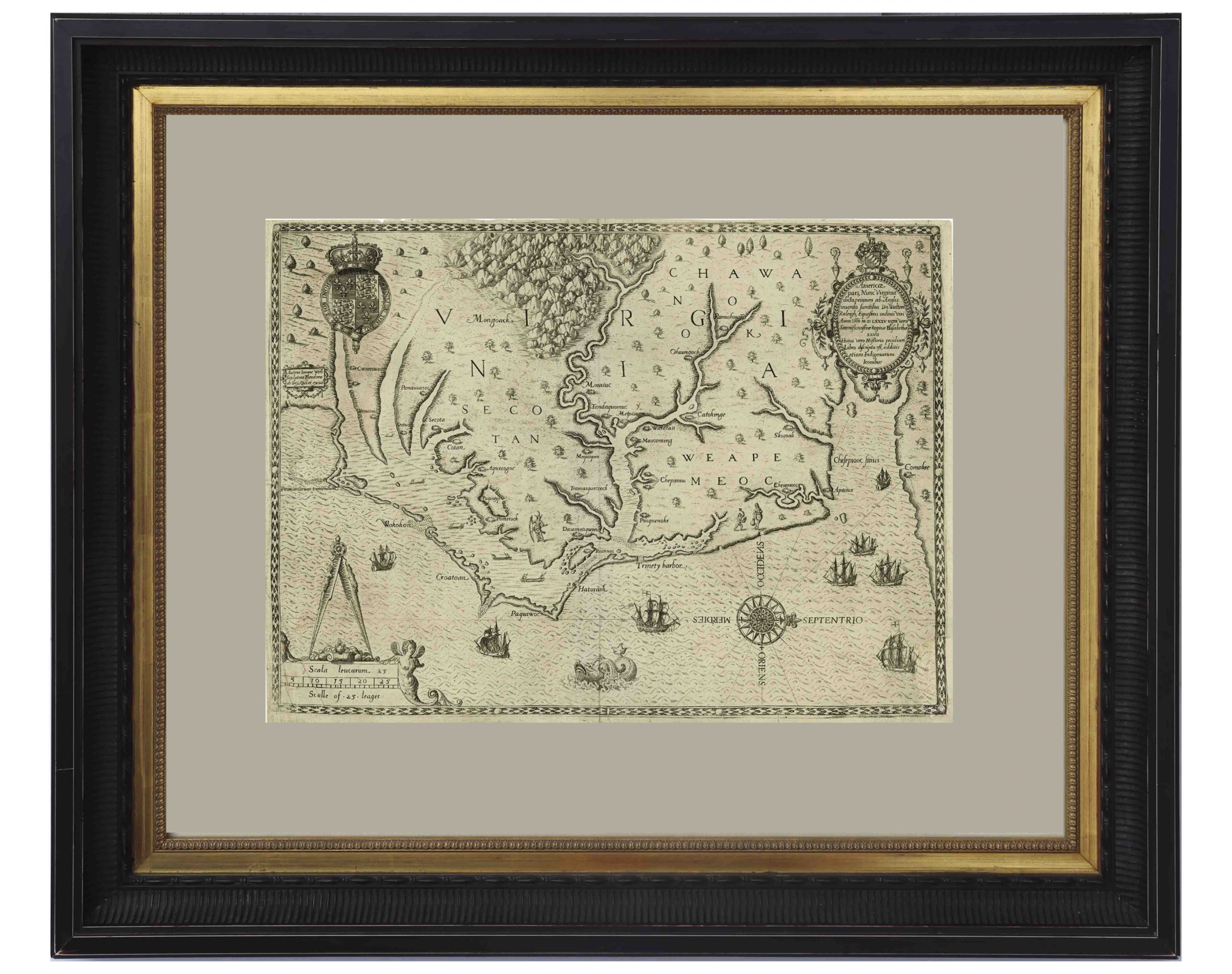
John White’s Map of Virginia From 1590 — The First Printed Map of Virginia and North Carolina
An important 16th century North American map known not only for its level of detail and accuracy, but also for its “firsts”: the first printed map of Virginia and North Carolina, the first to use Virginia in its title, the first to name the Chesapeake Bay, and also the first regional map showing the Roanoke Colony. Frankfurt: Theodor de Bry (engraver) for inclusion in his “Anglorum in Virginiam aduentus”, 1590.
Map is based on the work of cartographer, artist and explorer John White, one of the first settlers and Governor of the Roanoke Colony who, after sailing back to the Colony from England in 1587, had found all the colonists famously missing, their fate a mystery still unsolved. Philip Burden, who wrote the definitive reference book, “The Mapping of North America”, wrote of this map: “One of the most significant cartographical milestones in colonial North American history…the most accurate map drawn in the sixteenth century of any part of that continent.”
This full-sheet engraved map still retains its dark print, with the English Royal Arms at top left, and artistic touches throughout such as ships and sea monsters in the open ocean, and Native American canoeists in the inland waters. Map is the second state, with “C” laid over the “E” in Ehesepiooc. Map measures 16.675″ x 12.25″, nicely matted and framed to a size of 28″ x 23.5″. Expert repair to single vertical fold, and small area of repair to lower right corner, just touching the edge of the ship, where paper loss has been replaced. Overall in very good to near fine condition given age, displaying beautifully. Sold for $6,665.
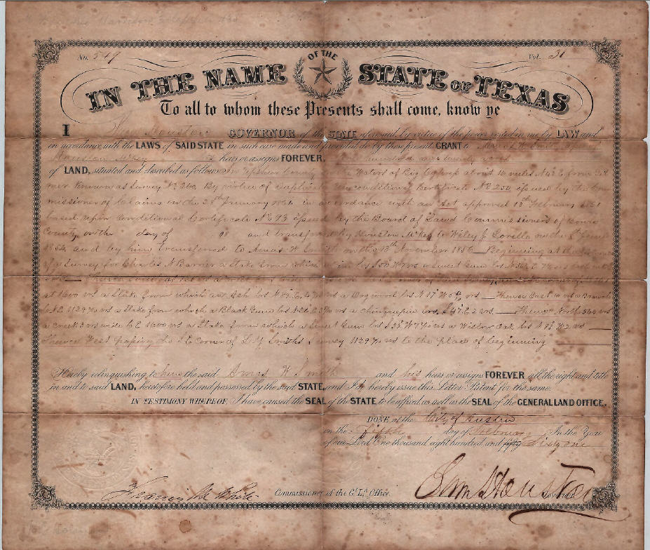
Sam Houston Signed Texas Land Grant
Exceptionally large signature of Sam Houston on Texas land grant, signed as the Governor of Texas. Upshur County land grant is dated 5 February 1861 and measures 12.5″ x 14.75″ with Houston’s signature at bottom right measuring 1″ x 4″. State of Texas blindstamped seal on bottom left. Document folded into eighths, with toning along foldlines. Foxing present along edges. Three small holes along center foldlines and registration docket writing to verso. Document overall in good condition with bold large signature an exceptional plus. Sold for $4,936.
FREE APPRAISAL. To buy, auction, sell or consign your George Wilkins Kendall The War Between United States and Mexico 1851 that is for sale, please email your description and photos to [email protected] of Nate D. Sanders Auctions (http://www.NateDSanders.com).
We offer the following services for your George Wilkins Kendall The War Between United States and Mexico 1851:
- Appraise George Wilkins Kendall The War Between United States and Mexico 1851.
- Auction George Wilkins Kendall The War Between United States and Mexico 1851.
- Consign George Wilkins Kendall The War Between United States and Mexico 1851.
- Estimate George Wilkins Kendall The War Between United States and Mexico 1851.
- Sell George Wilkins Kendall The War Between United States and Mexico 1851.