Sell or Auction Your Art of Drawing Colouring Fielding Lucas 1815 for up to Over $20,000 or More at Nate D. Sanders Auctions
FREE VALUATION. To buy, auction, sell or consign your Art of Drawing Colouring Fielding Lucas 1815 that is for sale, please email your description and photos to [email protected] of Nate D. Sanders Auctions (http://www.NateDSanders.com).
Free Appraisal, Auction or Sell Your Art of Drawing Colouring Fielding Lucas 1815
Fielding Lucas Jr. (September 3, 1781 – March 12, 1854) was an American cartographer, an artist, and a publisher of prominence during the early 19th century. He is known as the earliest successful commercial map publisher in the city of Baltimore. The first of his atlases was published in 1815–17, in which the maps are closely associated with the 1822 edition of Philadelphia atlas by Carey & Lea.
Below is a recent realized price for an Art of Drawing Colouring Fielding Lucas 1815 item. We at Nate D. Sanders Auctions can obtain up to this amount or more for you:
Art of Drawing Colouring Fielding Lucas 1815. Sold for over $20,000.

The following is some similar items we have sold:
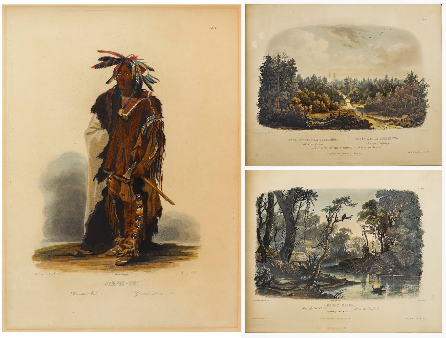
Karl Bodmer Prince of Wied’s Travels in the Interior
Stunningly beautiful collection of 81 hand-colored aquatints by the Swiss artist Karl Bodmer, a complete collection from the illustrated travelogue, “Prince of Wied’s Travels in the Interior of North America”. Bodmer, who journeyed with the German Prince Maximilian of Wied-Neuwied from 1833-34 along the Missouri River, produced what is considered the best depictions of the indigenous peoples and landscapes during the frontier era, an America then still unspoiled by western migration. Of the Native American tribes of the Great Plains that they encountered, Bodmer’s depictions of the Blackfeet and Mandan tribes are especially important as the populations of these tribes were greatly affected by the smallpox epidemic of 1837, thus making Bodmer’s work the last visual testament to their culture.
Prince Max, as he was called, chose Bodmer to accompany him on the expedition along the Missouri River to visually depict the scenes that the Prince would write about. The result is this collection: three volumes of text by the Prince and two volumes of aquatints by Bodmer, in the first Paris edition published by Chez Arthus Bertrand, 1840-43 (“Voyage dans l’interieur de l’Amerique du Nord”). Text volumes in French also include 37 wood-engraved illustrations, only lacking the map in completeness. The two complete volumes of illustrations include the large folio volume with 48 oversized hand-colored aquatints measuring approximately 24.5″ x 18″, and the quarto volume with 33 hand-colored aquatints measuring approximately 12.5″ x 10.25″. The complete set of 81 aquatints is magnificent in their display, a time capsule with their hand-coloring evoking the sense of awe and discovery of the expedition. All volumes are bound in half black morocco and blue paper-covered boards with gilt accenting, and with black morocco labels to illustrated volumes. Minor handling wear to volumes, with a few small repaired tears to plates, some plates supplied with variance to margins, minute toning and foxing, a few plates beginning to separate from binding. Overall a very good plus set with excellent display quality. Sold for $175,000.


Revolutionary War Map 1776
Revolutionary War map dated March 1776. “The Theatre of War in North America, With the Roads and a Table of the Distances…” Printed in London for R. Sayer and J. Bennett. Map depicts the area east of the Mississippi River from James Bay to Cape Canaveral, and locates provincial boundaries, towns, forts, roads, Indian villages, New England fishing waters, and the like. An inset is comprised of “Evan’s Polymetric Table of America,” which allows one to calculate the distance between most of the prominent towns. Text below the map reads, “A Compendious Account of the British Colonies in North America,” which devotes a paragraph of description to each of the North American colonies, including Florida, Canada, and the Province of Quebec. Issued separately by Sayer and Bennett, who also published “the American Military Pocket Atlas,” that year for the use of British officers. A notable map of the American Revolution, published the same year as the American Declaration of Independence. 20.75″ x 28.5″; 29.25″ x 37.5″ framed. Excellent condition. Sold for $6,000.

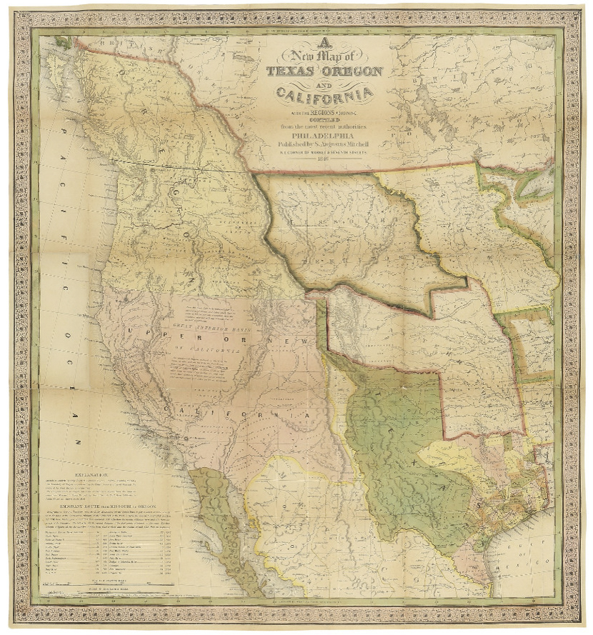
Map of Texas, Oregon and California From 1846
“A New Map of Texas Oregon and California with the Regions Adjoining. Compiled from the most recent authorities.” By cartographer Samuel Augustus Mitchell, published in 1846 as a pocket map, and considered the definitive map for settlers in the nation’s westward expansion during the Gold Rush. Philadelphia: Published by S. Augustus Mitchell, 1846. With contemporary hand-coloring, folding map by engraver H.N. Burroughs was Mitchell’s most important map, considered the defacto standard and thereby affecting subsequent maps of the area. It was the first to include recent explorations in the Great Basin, with boundary lines of Rio Grande to the south, and Oregon to the north at 54 degrees 40 minutes, above which are “British Possessions”. An inset to lower left entitled “Emigrant Route from Missouri to Oregon”, provides the distance between western cities and landmarks, undoubtedly aiding weary travelers. With decorative scrollwork along the margins, map measures 21″ x 22.5″ unfolded, nicely matted and framed to a size of 34.5″ x 41.5″. Some expert repair at fold separations and mild fading, overall in very good condition. Sold for $4,800.
Lotter New and Correct Map of North America 1784
Large four-sheet engraved map measuring nearly 4′ x 3.5′ showing North America in 1784, with sovereignty of the thirteen colonies belonging to the United States following the Treaty of Paris that concluded the Revolutionary War. Published in Ausburg, Germany by Mathew Albert Lotter and Georg Frederic Lotter, 1784. Map is titled at upper right, “A new and correct map of North America with the West India Islands. Divided according to the last Treaty of Peace, concluded at Paris the 20th of Jan. 1783. wherein are particularly distinguished the Thirteen Provinces wich [sic] compose the United States of North America”. A cartouche underneath shows tradesmen and workers on the banks of Bermuda, and two insets show Baffin and Hudson’s Bay beneath the Arctic, and land bordering the “Sea of California” partially described as “The Passage by Land to California”. Map measures 46.875″ x 41″. Professionally backed to linen and lightly mounted to board. Minute foxing and a few spots of repair. Overall very good to near fine condition given age including superior color contrast. With fascinating detail, map would anchor a room and serve as an excellent topic of ongoing reflection and discussion. Sold for $1,750.

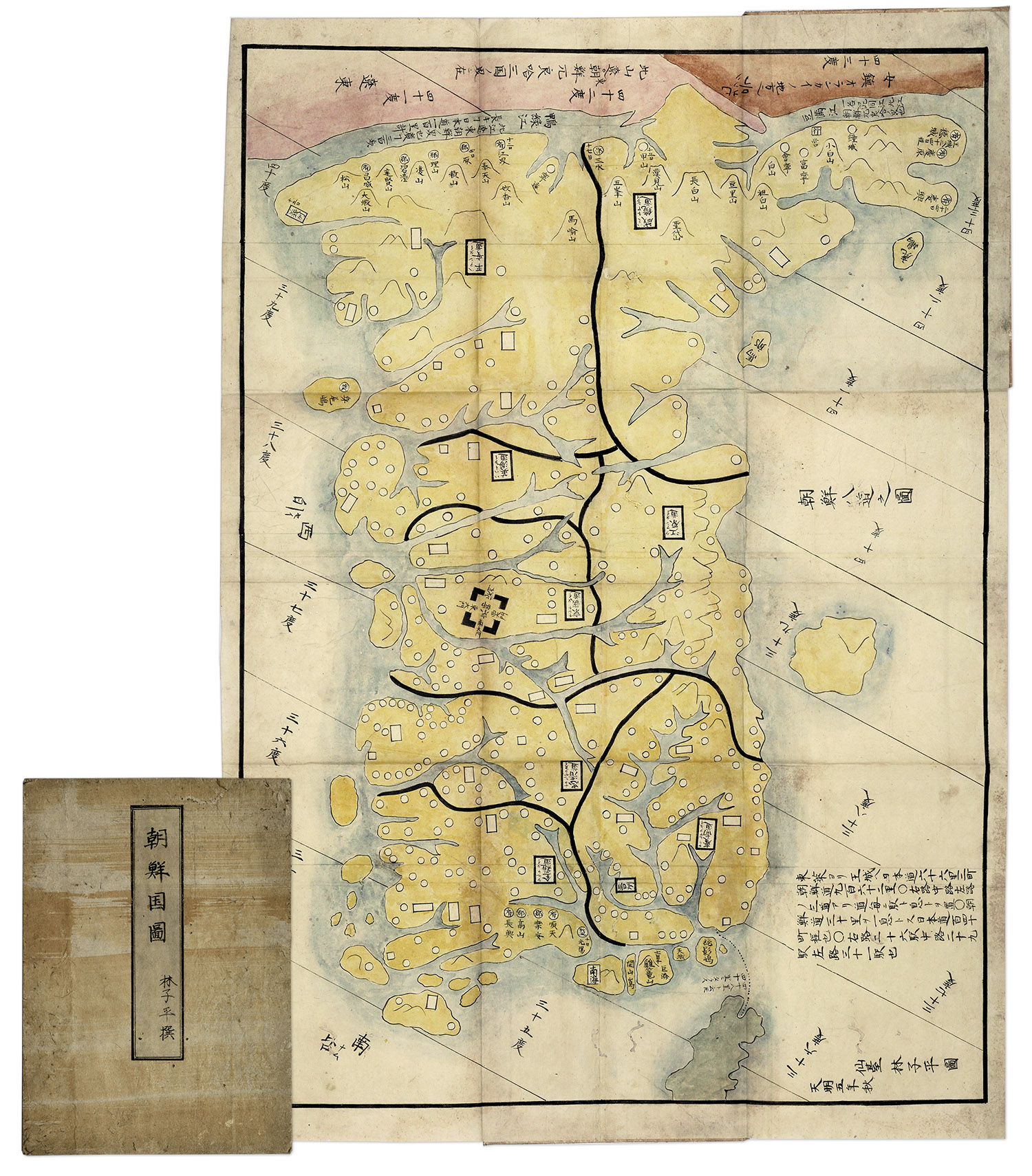
Hand-painted map of Korea by Hayashi Shihei, from Japan, circa 1785. Fold-out map shows the kingdoms outside Japan’s boundaries, but with the Kingdom of Joseon (Korea) being an important trading partner, the map was considered dangerous, and consequently banned by the Shogun in 1792. Has original cover boards and title slip. Measures 20” x 29” when folded out, and 7” x 9.5” when closed. Lightly toned and soiled, overall very good condition. Sold for $1,563.
FREE VALUATION. To buy, auction, sell or consign your Art of Drawing Colouring Fielding Lucas 1815 that is for sale, please email your description and photos to [email protected] of Nate D. Sanders Auctions (http://www.NateDSanders.com).
Art of Drawing Colouring Fielding Lucas 1815